


[ad name=”HTML-68″]
SAN JUAN — An extra tropical system not associated with Invest 91L was causing flash flood warnings to be issued for Puerto Rico on Thursday morning.
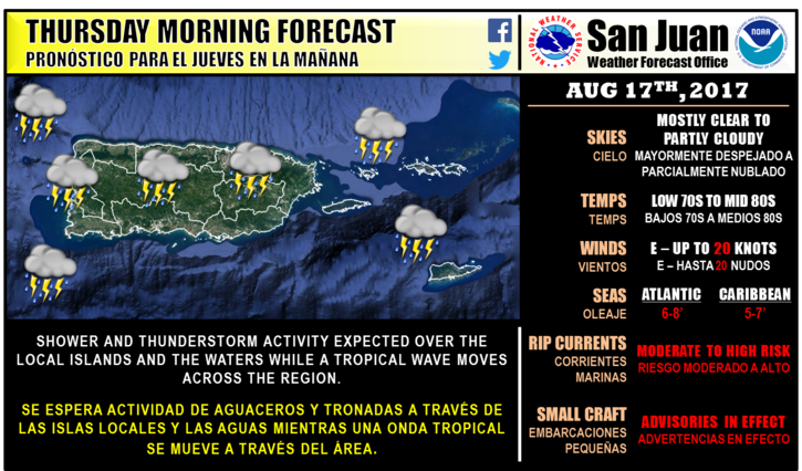
But the area of organized showers located 500 miles east of the Lesser Antilles called Invest 91L has a 90 percent chance of tropical development over the next five days as it travels west into the region.
It is expected to pass closest to the Virgin Islands on Friday.
“A surface high pressure across the central Atlantic will produce moderate to locally fresh easterly winds through the rest of the week,” the National Weather Service said. “An active tropical wave in the Mona Channel will move into Hispaniola later today, Showers and thunderstorms will be active across the regional waters. Potential Tropical Cyclone number 9 is expected to move across the Caribbean Sea south of the San Juan forecast Area between Friday and Saturday with increased seas in the Caribbean.”
Showers were expected to begin falling on St. Croix about 3 p.m. today, but they, too, are associated with the extra tropical system and not the outer bands of Invest 91L.
The National Hurricane Center has started issuing advisories for the latest tropical hot spot in the Atlantic — a patch of rough weather east of the Caribbean that’s now being called Potential Tropical Cyclone 9 and could become Hurricane Harvey.
It’s still early, but the system is forecast to become a hurricane that would make landfall somewhere between Nicaragua and Mexico’s Yucatan Peninsula. It does not appear to be a threat to Florida or anywhere else in the U.S.
We are now entering the busiest time of the Atlantic hurricane season, and it shows because Potential Tropical Cyclone 9, or PTC9, is one of four tropical watch zones in the Atlantic. One of those, Hurricane Gert, is in the Atlantic off Canada, no threat to land, and is expected to dissipate.
The other two are systems that are still at least 2,000 miles from Florida. They’re showing early signs of tracking in the general direction of Puerto Rico and the Bahamas, but forecasts this early out are riddled with uncertainty, forecasters say.
One has a 60 percent chance of formation over the next five days, while the other has a 40 percent chance over the same time period.
None of these pose an immediate threat to Florida’s weather. But that’s also because it was too early.
PTC9 is an area of low pressure about 500 miles east of the Lesser Antilles, on the eastern boundary of the Caribbean. An Air Force Reserve Hurricane Hunter was scheduled to investigate the disturbance Thursday afternoon.
Forecasters have given it an 80 percent chance of developing into a tropical cyclone during the next two days and a 90 percent chance of developing over the next five days.
Initial track forecasts have the potential hurricane making landfall somewhere between Nicaragua and Mexico’s Yucatan Peninsula on Tuesday.
When and if it becomes a tropical storm, it would take the name Harvey.
The “Potential Tropical Cyclone” advisories are new in 2017. Formerly, disturbances would have to become at least a depression before advisories were issued. The reason for the potential-cyclone advisories is to give people more warning, giving them more time to prepare.
A tropical cyclone can take the form of a tropical depression, tropical storm, or hurricane. Tropical depressions are characterized by maximum sustained winds of 38 mph, tropical storms have maximum winds of 73 mph, and hurricanes pack winds of 74 mph to over 155 mph.
Just behind it, 92L is located halfway between Africa and the Lesser Antilles. The storm has been given a 60 percent chance of becoming something more as it travels west-northwest at 15 mph.
Hurricane Gert is well off the eastern coast of the mainland U.S.
It is continuing to travel into the north Atlantic and is expected to weaken.
The storm is not a local threat to people in the territory.