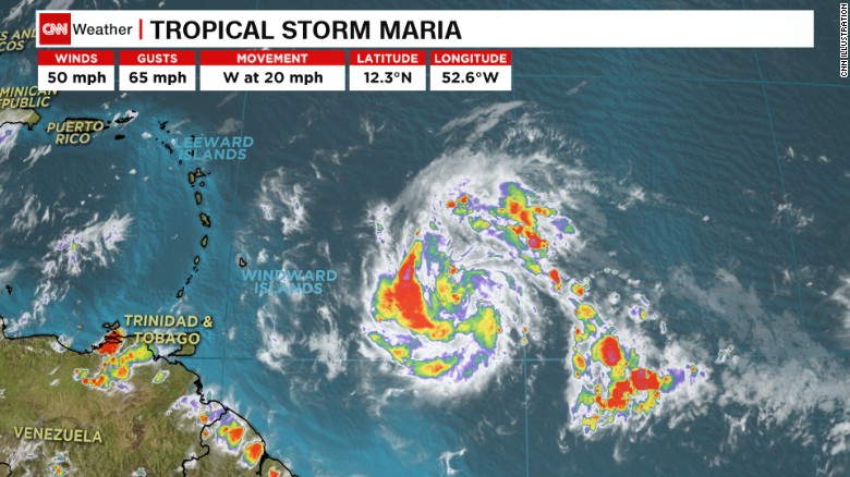
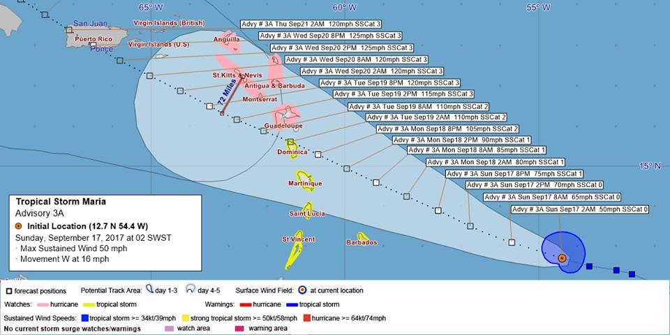
HURRICANE MARIA’S PROJECTED TIME PATH THRU THE CARIBBEAN REGION AS OF SUNDAY.
[ad name=”HTML-68″]SAN JUAN — Tropical Storm Maria formed Saturday in the western Atlantic Ocean, prompting a hurricane watch for areas battered by Hurricane Irma last week.
At 11 a.m., Maria was about 639 miles southeast of St. Croix and is packing maximum sustained winds of 65 mph, with gusts up to 75 mph. The storm is moving west-northwest towards the Lesser Antilles at 19 mph, according to the National Hurricane Center and the 2017 V.I. Freep Storm Tracker.
Maria is expected to gain strength and become a major hurricane through the weekend and become a hurricane by late Monday, forecasters said. Tropical storm force winds extend out 70 miles from its center of circulation.
According to NHC Advisory 3A, Hurricane Maria should pass 10 miles south of St. Croix about 3 a.m. on Wednesday with sustained winds of 150 mph as a Category 4 storm, subject to change if the storm wobbles or its forward speed increases or decreases.
Tropical storm watches are posted for Barbados, St. Lucia, Martinique, Dominica and St. Vincent and the Grenadines. The hurricane watch covers Antigua, Barbuda, St. Kitts and Nevis, Montserrat and Guadeloupe.
That means that areas of the Virgin Islands and Puerto Rico already devastated by Irma could again be dealing with hurricane conditions again by Tuesday or Wednesday.
Maria joins Tropical Storm Lee, which formed earlier Saturday in the eastern Atlantic Ocean.
Maria began attracting attention going into the weekend as Invest 96L, then was upgraded to Tropical Depression 15 and then the named tropical storm and hurricane “Maria.”
It was upgraded to Hurricane Maria at 5 p.m. on Sunday with sustained winds of 75 mph.
Lee became Tropical Depression 14 on Thursday and is spinning about 720 miles west-southwest of Cape Verde off northwest Africa and packing maximum sustained winds of 40 mph, according to the NHC.
Lee isn’t expected to gain much strength over the next 48 hours and will likely fade to a tropical depression by Wednesday without affecting land, the center said.
These new Atlantic systems join Hurricane Jose, a Category 1 storm spinning about 480 miles south-southeast of Cape Hatteras, North Carolina.
Jose could bring rain and rain and wind to the U.S. Northeast early next week.
Hurricane Hugo struck St. Croix on Sept. 17-18, 1989.
HURRICANE MARIA’S PROJECTED PATH ACCORDING TO THE 2017 V.I. FREEP STORM TRACKER (ABOVE)


