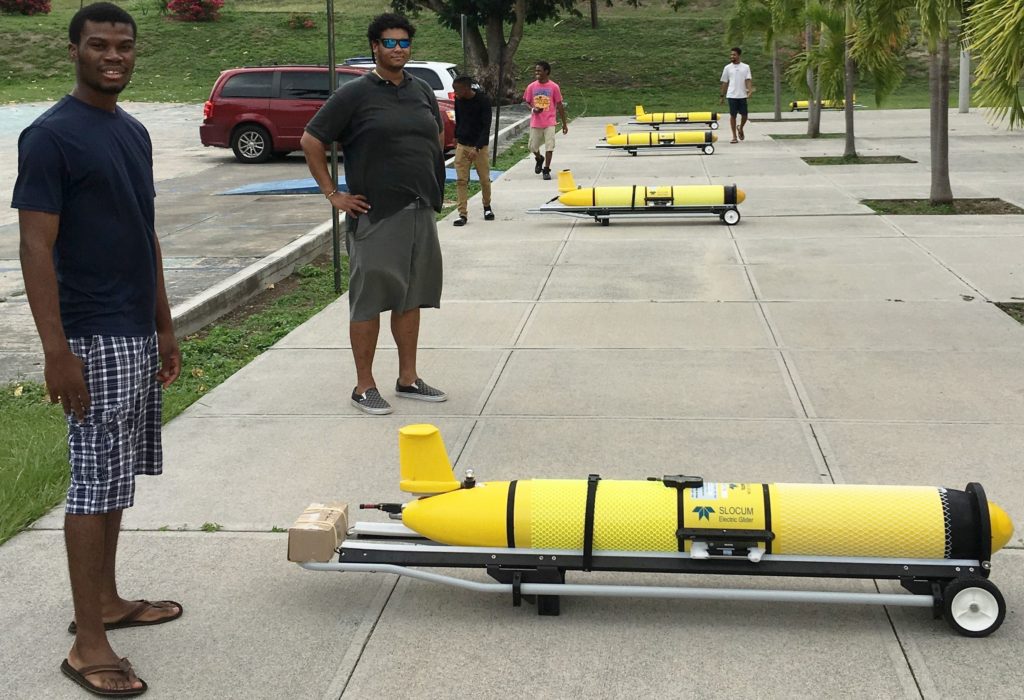
The University of the Virgin Islands (UVI) is releasing data-collecting drones into the Caribbean Sea and Atlantic Ocean.
[ad name=”HTML-68″]FREDERIKSTED — The University of the Virgin Islands (UVI) through an agreement with Ocean and Coastal Observing – Virgin Islands (OCOVI), has lent its support to housing data-collecting underwater drones that will aid in improved hurricane forecasting.
The project to deploy ocean gliders in USVI waters begun on July 17, 2018. The deployment schedule saw the first glider going into the water 15 miles south of St. Thomas-St. John on July 17, followed the next day, July 18, by two deployments north of St. Croix and one west of St. Croix. On July 19, the fifth Glider was released at a station northwest of St. Thomas.
The Summer long project includes ocean gliders plying the waters of the U.S. Virgin Islands as a means of advancing the understanding of ocean characteristics and contributing to improving hurricane forecast models. Additionally, two of the gliders are carrying passive acoustic recorders to listen for whale sounds.
“UVI’s Center for Marine and Environmental Studies and its emerging oceanography program is very excited to be able to participate in this important project,” said Paul Jobsis, acting director of the Center for Marine & Environmental Studies. “We plan to continue this work in the future with OCOVI, NOAA, the US Navy and CariCOOS-UPR,” he said. “The logistics and student involvement we were able to facilitate is important. UVI students are some of the best and this shows them that globally important science is happening in the Virgin Islands.”
Six students who are currently participating in the National Science Foundation- Historically Black Colleges and Universities (NSF-HBCU) Summer Undergraduate Experience program had the unique opportunity to be part of the glider pilot program.
Students involved:
• Belize Saunders – Applied Mathematics major
• Samuel Gittens Jr. – Biology major
• Jair Smith – Computer Science major
• Kenique Liburd – Computer Science major
• Kaleb Liburd – Computer Science major
• Elisha Brunant – Computer Science major
The University student interns have closely involved in this new project. The students assisted in the preparation and the launch of the gliders in the deep water Virgin Islands Basin. “This is a unique experience for undergraduate students at the University of the Virgin Islands to participate in such an exciting initiative in the Territory,” said Dr. Marc Boumedine, Summer Undergraduate Research Experience (SURE) mentor. “The students are learning about advanced technologies and how to turn data into practical knowledge that will impact our understanding of oceans and the earth.”
The joint project is coordinated by Ocean and Coastal Observing – Virgin Islands (OCOVI), working with UVI’s Center for Marine and Environmental Studies (CMES), National Oceanic and Atmospheric Administration (NOAA) and the US Navy to manage the gliders during their time in USVI waters. OCOVI assured USVI participation, secured a portion of the funding for the USVI and provided scientific and technical services. UVI through CMES provided the boats and additional scientific and technical service and through the Summer program provided the student Interns. The US Navy provided all five gliders and acts as “ground control” from its headquarters during the mission. The gliders are remotely controlled by researchers from Rutgers University’s Coastal Ocean Observing Lab. Rutgers University partnered in fundraising and provided Dr. Travis Miles as the chief scientist in charge of deployments; and CARICOOS-UPR, which funds OCOVI was instrumental in attracting the project to the region.
OCOVI represents CARICOOS (Caribbean Coastal Ocean Observing System) is working on behalf of the US Integrated Ocean Observing System (IOOS). OCOVI is responsible for the five gliders owned by the US Navy with the hope of using this 2018 experience to support a permanent ‘hurricane glider’ fleet for the region in future years.
Simultaneously, operating out of the University of Puerto Rico, Mayagüez, CARICOOS and NOAA scientists have launched as many as eight gliders in waters adjacent to Puerto Rico.
Unmanned ocean gliders are capable of spending months at sea – continuously collecting and transmitting underwater data – measuring water temperature and other properties. They are the most effective tool available to collect the information that allows scientists to monitor the ocean conditions that affect hurricane intensity.
Ocean gliders propel themselves without propellers by adjusting their buoyancy to slowly descend to and ascend from the depths of the ocean. As they do so, onboard instruments record water properties such as temperature and salinity. Gliders can be ‘steered’ by adjusting the angle at which they ascend or descend; they are piloted remotely to maintain or change their approximate positions.
Mariners and fishermen are urged not to interfere with glider activity if they encounter them on the water.
People who encounter a glider that appears to be fouled or in other distress are asked to contact OCOVI representatives, Dr. Roy Watlington at (340) 643-8183 or via email at rawatlington@gmail.com


