


CHARLOTTE AMALIE — Commissioner Dawn L. Henry, Esq. of the Department of Planning and Natural Resources (DPNR) reminds the public that pursuant to Title 29, Chapter 3, Section 281, Subsection (a), (7), Rules and Regulations of the Virgin Islands Historic Preservation Commission, Section 281 -11 2(A).
No off-premises signs, including but not limited to sandwich boards and other free-standing signs, are allowed, other than part of uniform directories; Section 281-11 2(H).
No political signs or advertising of any type is allowed within the Christiansted and Frederiksted Historic Districts, Title 29, Chapter 17 Subsection 952(R). Political Campaign Headquarters will be allowed standard signs as reviewed and approved by the St. Croix Historic Preservation Committee.
Christiansted Historic District including the National Historic Site and areas adjacent thereto, which is bounded as follows: Beginning at a point which is the extension of Lobster Street at the edge of the harbor, then running southwesterly along the south side of Lobster Street to its intersection with Hospital Street, thence running east along the north side of Hospital Street to the intersection of New Street, thence running south westerly along the south side of New Street to its intersection with Princess Street, thence running northwesterly along the west side of Princess Street to a point 100′ south of East Street, thence running parallel to East Street until this line intersects with East Street at a point 200′ east of Peter’s Farm Hospital Street, thence running south for a distance of 300′, thence turning and running west for a distance of 200′ parallel to East Street to a point which is the extension of Peter’s Farm Hospital Street, thence continuing north along Peter’s Farm Hospital Street to its intersection with Western Suburb Street, thence running east along the north side of Western suburb Street to a point 100′ west of West Street, thence running north parallel to West Street to a point 125′ north of West Lane, thence turning and running easterly 100′ to the west side of West Street, thence running along the west side of West Street to the harbor, thence continuing along the shoreline to the point of beginning.
Frederiksted Historic District is bounded as follows: Beginning at the southwest corner of Frederiksted where Fisher Street adjoins the sea, the line runs approximately east and within 100 feet of the south side of Fisher Street to the southwest corner of Plot No. 40E of La Grange where New Street intersects Fisher Street; thence within 100 feet of the east side of New Street to the intersection of Queen Cross Street; thence east within 100 feet of both sides of the La Grange Road to the intersection of East Street; thence north along the rear lot lines of the properties on East Street to the rear lot line of the cemetery; thence northwest to the intersection of New Street and Custom House Street; thence west along the rear lot lines of Custom House Street to the intersection of Prince Street; thence north along the rear lot lines of Prince Street to the boundary of the park; thence west along the park boundary to the intersection of King Street; thence west to the sea; thence south along the shore to the beginning.
Event Posters, Flyers, Banners, Political Advertisement that signs that have been erected within these Historic Districts shall be removed immediately or the political aspirant will be fined as permitted by V.I. Law. For additional information, contact the V.I. State Historic Preservation Office at 776-8605 on St. Thomas.
Charlotte Amalie Historic District Boundary
The boundary of the Charlotte Amalie Historic District begins at the projection of the southern property line of 40-aab Bjerge Gade (Theodore Tunick Building) to Veterans Drive, and the mean high water mark at the shore of Charlotte Amalie Harbor, thence east to Bjerge Gade continuing east along the southern property line of 40-aa Taarneberg, thence north along the eastern property line of 4-aa Taarneberg, thence west along the southern property line of 40cc Taarneberg, thence north along the western property line of 40cc Taarneberg, thence east along the northern property line of 40cc Taarneberg, thence north along the western property line of 40cc Taarneberg, thence west along the northern property line of 40c Taarneberg to a point that intersects with the western property line of 24D Norre Gade, thence north along 24D Norre Gade thence west along the southern property line 24C Norre Gade, thence north along the eastern property line of la, 2, 3 and 4 Bjerge Gade, thence east along the southern property line of 24ba and 24bc Taarneberg, thence north along the eastern property line of 24bc and 24b Taarneberg, thence across Norre Gade to the southwestern corner of 1 Fredericksberg Gade (Dudley, Topper & Feuerzeig Building), thence east along the southern property line of 1 Fredericksberg, thence north along the eastern property line of 1 Fredericksberg, thence east along the southern property line of l-a Kongens Gade (International Capital Management Company), thence north along the eastern property line of l-a Kongens Gade to Dronningens Gade across to the southern property line of 73a Dronningens Gade, thence west along Dronningens Gade to 65-a Dronningens Gade, thence north along the western property line of 65-a Dronningens Gade, thence east along the northern property line of 65a, 65b, 66, 67 and 67aa Dronningens Gade, thence north along the eastern property line of 9d and 8b Prindsens Gade across Prindsens Gade to the southern property line of 9 and 10 Hospital line (Human Services Parking Lot), thence along the same thence north along the western property line of 9 and 10 Hospital line, thence west along the southern side (road southside of Lionel Roberts Stadium) of Hospital line to the intersection of Lille Taarne Gade (top of Blackbeard’s Hill), thence north across Hospital line and along the eastern property line of 100 Hospital Ground, thence south along the western property line of 100 Hospital Ground, thence west along the northern property line of 37 Dronningens Gade to Store Taarne Gade, thence south along the western side of Store Taarne Gade, thence west along the northern property line of l3ba and 13b Kommandant Gade, thence north along the Louisenhoj Road to 10 Adele Gade, thence west along the northern property line of 10 Adele Gade, thence north along the western property line of 8G Lyttons Fancy, thence west along the northern property line of 8L, 8E, SD, 8B and 8A Lyttons Fancy, thence south along the western property line of SA Lyttons Fancy, thence south along the southern side of the road continuing south along the western property line of l6F Lyttons Fancy across the gut to the northern most corner of 16a Palm Straede thence west along the southern property line of 16a Palm Straede across Palm Straede and continuing along the southern line of 16HA, 16HC, and 16H to Cathrineberg Road, thence north along the western side of Cathrineberg Road thence west along the southern property line of 101, 108 Agnes Fancy continuing across the road thence west along the northern property line of 1A Cathrineberg, thence south along the west property line of 1A Cathrineberg, thence west along the southern property lines of 11 & 11A Cathrineberg, thence west across Northsidevej continuing along the northern side of Tamarind Gade to Vester Gade continuing west along the northern property line of 35 Vester Gade across the gut along the northern property line of 1A and 1BBA Silke Gade to Pile Gade, thence south along the eastern property line of 2AA Silke Gade, thence west along the northern property line of 2cc, 2a, 3a Silke Gade 8b and 8c Jode Gade 2a and lb Gaase Gade 7b and 8b Silke Gade, thence south along the western property line of 8b and 8a Silke Gade to Silke Gade, thence west along the northern property line of 9Q Nordside Tvaer Gade, thence east along the southern property line of 9Q Nordside Tvaer Gade thence south along the eastern property line of 9S Nordside Tvaer Gade to Smal Strade, thence east along the northern property line of 6bb and 6bba Borger Gade, thence east along the northern property line of 6d Borger Gade, Gamble Gade, thence west along the southern side of Gamble Gade, thence south along the western property line of 11B Borger Gade, thence east along the southern side of Regjerings Gade, thence south along the eastern property line of l2aa Borger Gade continuing south along the western property line of 13 Borger Gade to Jasmin Gade, thence west along the southern side of Jasmin Gade to Gamble Nordsidevei thence south along the western side of Gamble Nordsidevei to Prindsesse Gade, thence west along the northern side of Prindsesse Gade to Nye Nordsidevej continuing along the northern property line of 3 Nye Nordsidevej, thence south along the western property line of 3 and 2B Nye Nordsidevej continuing south along the western property line of 37 Kronprindsen Gade to Kronprindsens Gade, thence east along the northern side of Kronprindsens Gade to Nye Tvaer Gade, thence south along the western side of Nye Tvaer Gade to Veterans Drive and Water Front, continuing 200 feet into the water thence east to the point of beginning.
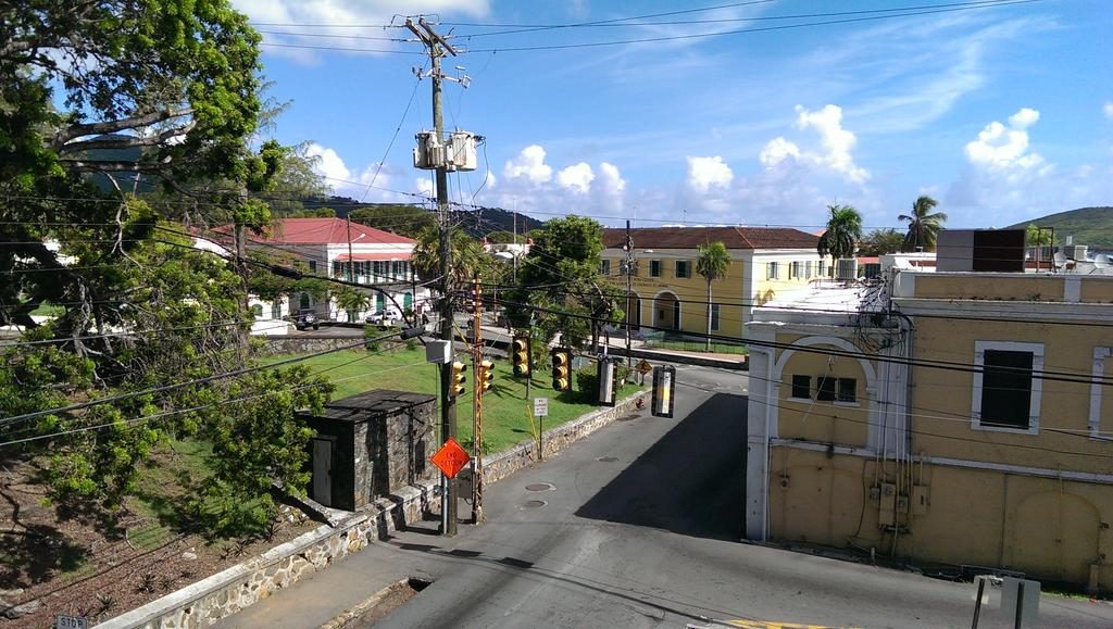
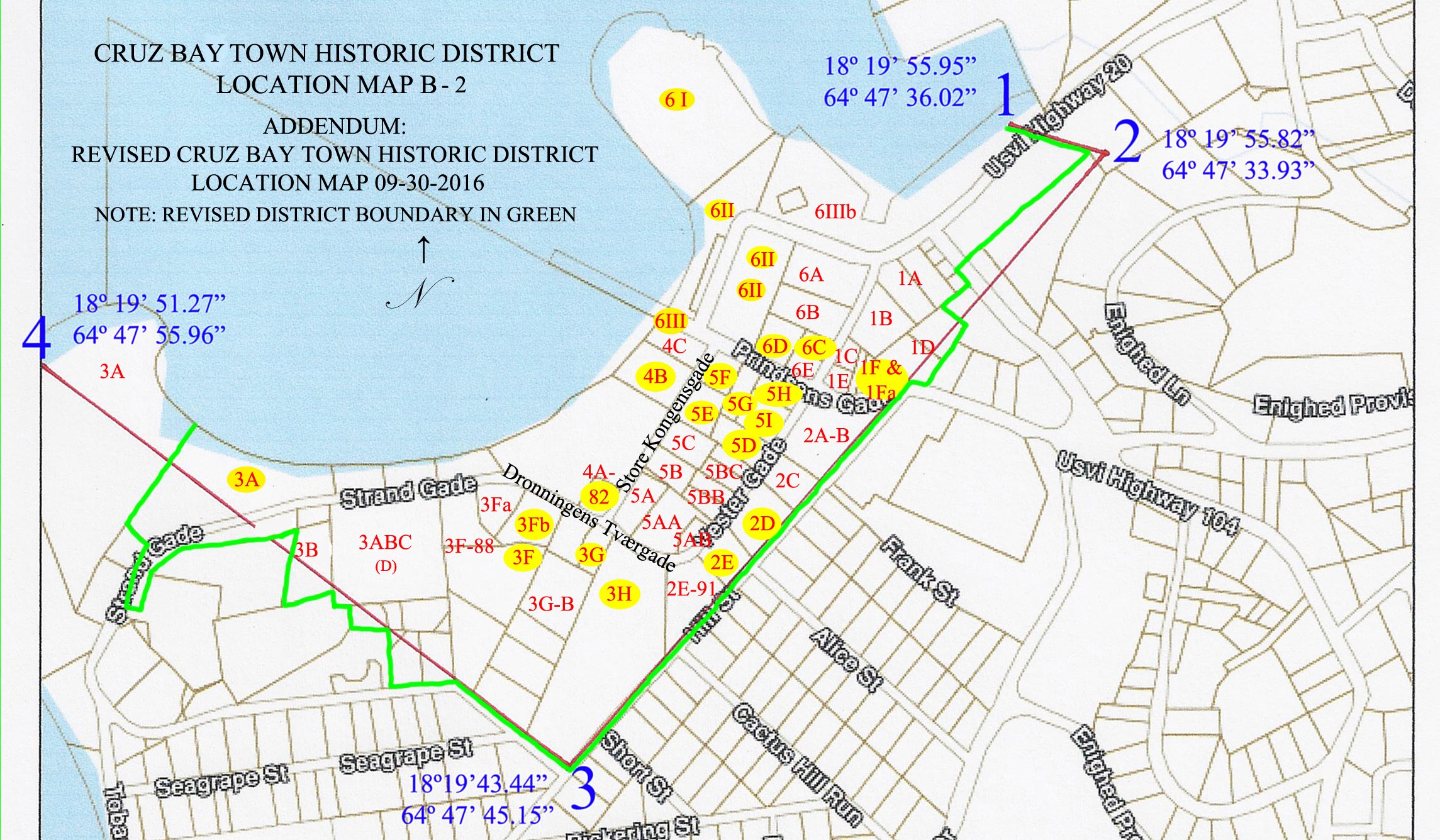
Cruz Bay Town District Boundary
The historical bounds of the Cruz Bay Town Historic District are as follows (see Map: A-2):
From Point #1, located at 18 ̊ 19’ 55.95” / 64 ̊ 47’ 36.02” on the waterfront at the north-west end of the Bulkhead at the Cruz Bay Creek, the boundary runs in a easterly direction approximately 214 feet to Point #2.
From Point #2, located at 18 ̊ 19’ 55.82” / 64 ̊ 47’ 33.93”, the boundary runs roughly west-southwest approximately 1,594 feet to Point #3, situated at the intersection of Hill Street and Frangipani Lane.
From Point #3, located at 18 ̊ 19’ 43.44” / 64 ̊ 47’ 45.15”, the boundary runs in a north-westerly direction approximately 1,274 feet to Point #4, situated on the shoreline of Gallows Point.
From Point #4, located at 18 ̊ 19’ 51.27” / 64 ̊ 47’ 55.96”, the boundary follows the shoreline of Cruz Bay back to Point#1
NOTE: The above description delineates the historic bounds of the Cruz Bay Town Historic District. Due to the fact that many properties within the Historic District have been re-surveyed and registered with the Office of the Recorder of Deeds with lot lines that do not conform with the town’s historic boundaries, official boundary lines of the Cruz Bay Town Historic District have been amended to conform with present lot lines of all plots within the district. (See Map B-2, Revised Cruz Bay Town Historic District Location Map 09-30-2016)
GOOD SIDE: The back side of a political sign near Tide Village on St. Croix.