MIAMI — Tropical Storm Isaac became less organized today as it moved across the eastern Caribbean on its way toward Central America, the National Hurricane Center said.
The center of the storm was located 80 miles west-southwest of Dominica and 240 miles southeast of St. Croix, the NHC said in its 2 p.m. EDT update. The storm was moving west at 18 mph and had maximum sustained winds of 45 mph.
“Little change in strength is expected over the next several hours as Isaac moves through the Leeward Islands. Gradual weakening is forecast after that as Isaac moves through the eastern Caribbean,” the Miami-based weather forecaster said.
Forecasters said Isaac will bring several inches of rain to some locations and possibly life-threatening surf conditions. Flash flooding could also occur.
A tropical storm warning is issued for the islands of Martinique, Dominica and Guadeloupe, and a tropical storm warning for Antigua, Monserrat, and St. Kitts and Nevis. Little change in strength is expected as Isaac leaves the outer islands and heads for the eastern Caribbean Sea.
Even with the storm’s brisk movement, rainfall can be heavy enough to trigger localized flooding. Tree and power line damage will also be possible.
After briefly reaching hurricane strength, Isaac weakened to a tropical storm on Monday night and is expected to maintain tropical storm strength through the end of the week.
As Isaac weakened earlier this week, it became a broader storm, allowing some gusty showers to reach farther away from the center.
The islands of Montserrat, Antigua and and St Lucia may get these showers in addition to rough seas and strong rip currents into early Friday.
Small craft may need to remain in port into Friday, as seas may remain dangerous until Isaac pulls away.
Many of these islands are still rebuilding following Hurricane Maria, which crossed the Lesser Antilles and moved over Puerto Rico almost a year ago.
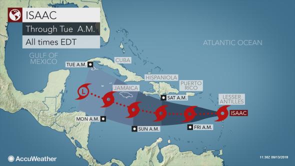
Beyond the Lesser Antilles, Isaac is forecast to track south of Puerto Rico and Hispaniola. An uptick in shower and thunderstorm activity is expected in these areas late in the week and over the weekend.
The southern-facing coastlines may have rough seas and well as stronger rip currents.
Residents and visitors of Jamaica will need to closely monitor the track of Isaac, as well.
The storm may pass very close to the island by the end of the weekend, bringing with it heavy rain and gusty winds.
Those on the island of Jamaica should make sure to have an emergency preparedness plan in place if you do not already have one.
The track of Isaac becomes more uncertain late in the weekend.
“Waters remain very warm over the western Caribbean and Gulf of Mexico,” said AccuWeather Senior Meteorologist Alex Sosnowski.
“Provided wind shear is low, there is the potential for Isaac to gain strength and possibly ramp up to a hurricane before approaching any land in along the U.S. Gulf Coast next week,” Sosnowski added.
If Isaac is unable to overcome the area of disruptive winds in the atmosphere, the environment instead could weaken Isaac to just a tropical wave before reaching the Yucatan Channel.
Should this be the case, lingering tropical moisture could bring heavier rains to the Yucatan Peninsula of Mexico as well as the western half of Cuba early next week.

