


SAN JUAN — A tropical storm formed just over 500 miles northeast of Puerto Rico on March 6, 1908.
This oddball storm tracked south-southwest, intensifying to a Category 2 strength as it tracked near the northern Leeward Islands of Saint-Barthélemy and Saint Kitts and Nevis.
“We of the islands in and around the northeastern corner of the Caribbean Sea were surprised to experience weather of so boisterous a character that it reminded us of what sometimes takes place in the regular hurricane season,” wrote John T. Quin from St. Croix in the May 1908 journal Monthly Weather Review.
Decades before satellites, reports of tropical cyclones in the Atlantic Basin were pieced together from either reports from ships or land areas already impacted.
Quin noted the rather bizarre shift in winds in St. Croix from the typical east-southeast trade winds and falling barometric pressure, which tipped him off that a storm was entering the Caribbean Sea.
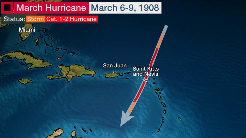
The path of this hurricane’s center was estimated to have tracked over the Leeward Islands of Saint Kitts and Nevis, based on observations of where smaller boats typically on the leeward (west) sides of the islands were either driven ashore or driven out to sea.
“It would seem that the cyclone in question followed a track opposite in every particular to the track usually followed by cyclones originating within the tropics in the hurricane season.” – John T. Quin (May 1908)
One sailboat broke from its anchor in St. Eustatius and was found “abandoned and stripped of mast and sails” off the southeast coast of Puerto Rico almost two weeks after the storm, according to Quin’s report.
Buildings were damaged in Saint Barthélemy, including a church. Tents housing peasants were damaged in Saint Martin/Sint Maarten, along with heavy damage to the local cotton crop.
Up to 8 inches of rain was reported in St. Kitts.
According to NOAA’s Hurricane Research Division, at least two percent of Atlantic named storms and hurricanes form outside the conventional June-November hurricane season.
Seven of the past nine seasons have generated a named storm before the June 1 hurricane season start date, including 2012, 2015, 2016, 2017, 2018, 2019 and 2020.
May has had the most named storms before June 1 since 2012 with eight. The most recent storms are Arthur and Bertha in May 2020, which both brought rain and gusty winds to parts of the Carolinas.
Andrea (2019), Alberto (2018), Bonnie (2016), Ana (2015), Beryl (2012) and Alberto (2012) are the other May storms that have occurred in the past nine years.
In 2017, Tropical Storm Arlene became only the second April Atlantic tropical storm since satellite coverage of the basin began in the mid-1960s.
Alex in 2016 was an extreme outlier in the historical record after it became a hurricane near the Azores in January.
The National Hurricane Center decided on one change in 2021 for earlier storm monitoring. The agency will begin issuing its routine Tropical Weather Outlooks, which provide the probability of tropical cyclone formation during the next 2 and 5 days, on May 15 instead of June 1. Those outlooks were previously only issued on an as-needed basis prior to June 1 in previous years.