


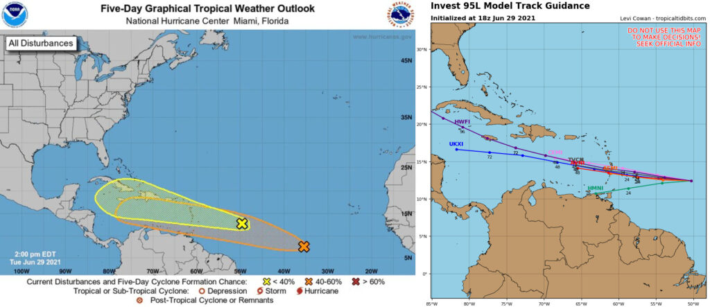
MIAMI —The National Hurricane Center is monitoring two tropical waves in the Atlantic; including one that is better organized as of today and showing improved odds of development.
In the mid-Atlantic, disorganized showers and thunderstorms associated with a tropical wave continue to move west at about 15 to 20 mph, the NHC said in a 2 p.m. update. The wave is about 650 miles east of the Lesser Antilles.
The wave has a 20 percent chance of becoming a tropical depression or storm in the next two days and a 30 percent chance of doing so in the next five.
Also, the NHC identified a second tropical wave 900 miles southwest of the Cabo Verde islands that became better organized, the NHC said in an 2 p.m. update.
The wave has improved odds of developing now showing a 20 percent chance of becoming a tropical depression or storm in the next two days and a 40 percent chance of doing so in the next five.
Should either wave organize and develop maximum sustained winds of 39 mph or greater, the first to do so will be the fifth named storm of the year and receive the name, Elsa. If they both develop, the slower of the two will be named Fred.
Also, remnants of the formerly known Tropical Storm Danny fizzled earlier Tuesday as the storm made its way through South Carolina and over Georgia, according to the NHC’s 12:30 p.m. update. Meanwhile,
The fourth named storm of the season formed off South Carolina’s coast Monday afternoon, but weakened to a tropical depression at around 11 p.m. Monday after making landfall in South Carolina, the NHC said.
Early this morning, Danny weakened further to remnants with its maximum sustained winds dropping to 25 mph before it fizzled out, the NHC said.
