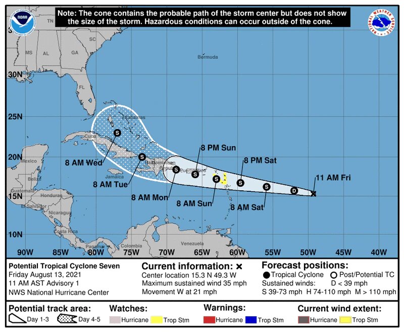
SAN JUAN — Potential Tropical Cyclone Seven is expected to become the seventh named storm of the year by tomorrow, the National Hurricane Center said in its 11 a.m. update today. If the disturbance develops it will get the name Grace.
The tropical wave is 840 miles east of the Lesser Antilles and has a 80 percent chance of either becoming the next depression or tropical storm of the year within the next two to five days, the NHC said. However, meteorologists are seeing the wave’s maximum sustained winds are near 35 mph and has higher gusts.
Atlantic conditions are ripe for growth and a tropical depression is likely to form tonight, following another growth spurt into a tropical storm formation by tomorrow, the NHC said.
Currently, the wave does not have a closed circulation, and its associated showers and thunderstorm activity remain disorganized.
Still, the wave is cruising through the Atlantic at a fast 21 mph. The GEFS and European storm models project similar paths for the potential Grace as Tropical Depression Fred. At its quick pace, the wave is expected to reach the Leeward Islands Saturday night, the Virgin Islands Sunday and Puerto Rico Sunday night.
A tropical storm watch was issued for Antigua and Barbuda’s St. Kitts and Nevis, and Montserrat as well as the Netherlands’ territories Saba and Sint Eustatius.
The NHC said it will continue to monitor the future storm Grace across the tropical Atlantic, located about 900 miles east-southeast of Puerto Rico and the U.S. Virgin Islands.
The formation chance through 48 hours is high (80%), as shown by the area shaded in red in Figure 1.
NHC mentions the possibility of requiring Tropical Storm Watches or Warnings for Puerto Rico and the U.S. Virgin Islands over the next day or so.
Regardless of development, this disturbance has the potential to bring locally heavy rain, as well as possibly gusty winds and deteriorating marine and coastal conditions by Sunday through at least Monday.
El Centro Nacional de Huracanes (CNH) está actualmente monitoreando una onda tropical (Potential Tropical Cyclone Grace) a través del Atlántico tropical, localizada a cerca de 900 millas al este de las Islas VírgenesEstadounidenses y Puerto Rico. La probabilidad de formación en 48 horas es alta (80%), dentro del áreasombreada en rojo en la Imagen 1.
CNH menciona la posibilidad de requerir Vigilancias o Avisos de TormentaTropical para Puerto Rico y las Islas Vírgenes Estadounidenses durante el próximo día más o menos.
Independientemente del desarrollo, este disturbio tiene el potencial de traer lluvias localmente fuertes, así comoposiblemente ráfagas de viento y el deterioro de las condiciones marítimas y costeras entre el domingo hastapor lo menos el lunes.

