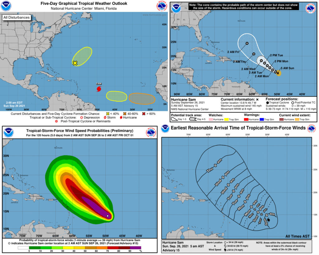
MIAMI — Hurricane Sam explosively strengthened on Saturday and became the season’s fourth major hurricane. Sam’s winds jumped to 140 mph on Saturday afternoon, making it a Category 4 hurricane.
The National Hurricane Center said Sam could get even stronger before weakening some.
Sam is far from land in the central Atlantic and is expected to slow down over the open ocean.
As of 11 a.m. today, the eye of Hurricane Sam was located about 905 miles east-southeast of the northern Leeward Islands and was moving west-northwest at 8 mph.
Sam currently has sustained winds of 145 mph. Category 4 winds begin at 130 mph.
There are no coastal watches or warnings in effect for the Caribbean at this time.
The storm’s track continued to fuel speculation on the U.S. Virgin Islands and Puerto Rico, but it is still too early to know with any certainty that Sam will stay away from our area.
It will be one to watch for the Lesser Antilles, however.
Sam is expected to track to the west and then northwest, which could take it near the islands.
But there are still days to watch: “Based on the NHC forecast, and all of the other guidance, Sam is expected to still be well to the east or northeast of the northern Leeward Islands through day 5,” the hurricane center said Saturday afternoon.
Forecasters said waves from Sam will reach the Lesser Antilles early next week and could cause life-threatening surf and rip currents.
ELSEWHERE IN THE ATLANTIC
The hurricane center was also watching the west coast of Africa. A tropical wave is expected to move off the coast and into the eastern Atlantic in a few days, and it could become the next tropical depression by midweek.
It is forecast to track to the west at 10 to 15 mph, forecasters said.
Forecasters are also monitoring another area of disturbed weather — the remnants of Tropical Storm Peter — located several hundred miles south of Bermuda.
Conditions may be somewhat conducive for slow development in the next few days as the system moves northeastward at 5 to 10 mph. It had a 20 percent chance of becoming a tropical depression in the next five days.
1. An elongated area of disorganized showers and thunderstorms associated with the remnants of Peter is located several hundred miles south-southeast of Bermuda. Upper-level winds only appear marginally conducive for some slow development of this disturbance over the next few days as it moves northeastward at about 10 mph. * Formation chance through 48 hours…low…10 percent. * Formation chance through 5 days…low…20 percent.
2. A tropical wave is expected to move off the west coast of Africa tomorrow. Environmental conditions are forecast to be conducive for gradual development thereafter, and a tropical depression could form by midweek while the system moves westward to west-northwestward at 10 to 15 mph over the far eastern tropical Atlantic. * Formation chance through 48 hours…low…near 0 percent. * Formation chance through 5 days…medium…60 percent.
3. A broad area of low pressure could form over the eastern or central tropical Atlantic early this week, to the west of the tropical wave that will be moving off the coast of Africa. Thereafter, environmental conditions could support some development of this disturbance while it moves westward at 5 to 10 mph through the middle of the week. * Formation chance through 48 hours…low…near 0 percent. * Formation chance through 5 days…low…30 percent.
The Atlantic hurricane season ends on November 30.

