


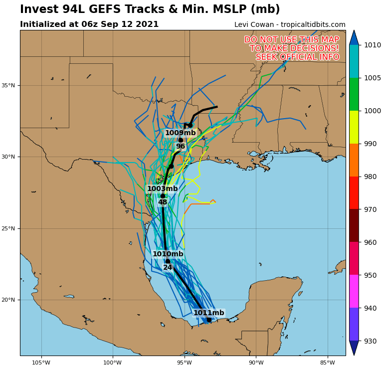
MIAMI — The center of Tropical Storm Nicholas was located by reconnaissance aircraft near latitude 20.5 North, longitude 94.8 West. Nicholas is moving toward the north-northwest near 13 mph (20 km/h), and this general motion is expected to continue through tonight.
A slower northward or north-northeastward motion is forecast by late Monday or Monday night. On the forecast track, the center of Nicholas will pass near or just offshore the the coasts of northeastern Mexico and South Texas late Monday, and approach the south or central Texas coast Monday night or early Tuesday.
Data from an Air Force Reserve reconnaissance aircraft indicate that the maximum sustained winds are near 40 mph (65 km/h) with higher gusts. Gradual strengthening is forecast while Nicholas approaches the northwestern Gulf coast during the next day or so.
Tropical-storm-force winds extend outward up to 105 miles (165 km) from the center.
The estimated minimum central pressure is 1008 mb (29.77 inches).
Watches and Warnings
A Tropical Storm Warning is in effect for the coast of Texas from the Mouth of the Rio Grande to Port Aransas.
The Government of Mexico has issued a Tropical Storm Warning from Barra el Mezquital northward to the U.S./Mexico border.
A Storm Surge Watch is in effect for the coast of Texas from the Mouth of the Rio Grande to High Island.
A Tropical Storm Watch is in effect for the coast of Texas from north of Port Aransas to High Island.
SUMMARY OF WATCHES AND WARNINGS IN EFFECT:
A Tropical Storm Warning is in effect for, * Mouth of the Rio Grande to Port Aransas Texas * Barra el Mezquital to the U.S./Mexico border
A Storm Surge Watch is in effect for, * Mouth of the Rio Grande to High Island Texas
A Tropical Storm Watch is in effect for, * North of Port Aransas to High Island Texas
A Tropical Storm Warning means that tropical storm conditions are expected somewhere within the warning area within 36 hours.
A Storm Surge Watch means there is a possibility of life-threatening inundation, from rising water moving inland from the coastline, in the indicated locations during the next 48 hours. For a depiction of areas at risk, please see the National Weather Service Storm Surge Watch/Warning Graphic, available at hurricanes.gov.
A Tropical Storm Watch means that tropical storm conditions are possible within the watch area, generally within 48 hours.
Interests elsewhere along the upper Texas coast should monitor the progress of this system.
For storm information specific to your area in the United States, including possible inland watches and warnings, please monitor products issued by your local National Weather Service forecast office. For storm information specific to your area outside of the United States, please monitor products issued by your national meteorological service.
Land Hazards
Key messages for Nicholas can be found in the Tropical Cyclone Discussion under AWIPS header MIATCDAT4, WMO header WTNT44 KNHC and on the web at hurricanes.gov/graphics_at4.shtml?key_messages
RAINFALL: Nicholas is expected to produce storm total rainfall of 5 to 10 inches, with isolated maximum amounts of 15 inches, across portions of coastal Texas into southwest Louisiana today through the middle of the week. This rainfall may produce areas of flash, urban, and isolated river flooding.
Over the eastern portions of the Mexican state of Tamaulipas rainfall amounts of 2 to 5 inches can be expected today into Monday.
STORM SURGE: The combination of a dangerous storm surge and the tide will cause normally dry areas near the coast to be flooded by rising waters moving inland from the shoreline. The water could reach the following heights above ground somewhere in the indicated areas if the peak surge occurs at the time of high tide,
Mouth of the Rio Grande to High Island, TX, 2-4 ft Baffin Bay, Corpus Christi Bay, Aransas Bay, San Antonio Bay, Matagorda Bay, and Galveston Bay, 2-4
The deepest water will occur along the immediate coast in areas of onshore flow, where the surge will be accompanied by large and dangerous waves. Surge-related flooding depends on the relative timing of the surge and the tidal cycle, and can vary greatly over short distances. For information specific to your area, please see products issued by your local National Weather Service forecast office.
WIND: Tropical storm conditions are expected to first reach the coast within the warning area in northeastern Mexico and southern Texas by Monday afternoon, making outside preparations difficult or dangerous. Tropical storm conditions are possible within the watch area by late Monday night or early Tuesday.
For the North Atlantic…Caribbean Sea and the Gulf of Mexico:
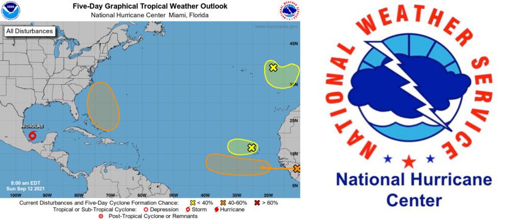
1. Showers and thunderstorms associated with a broad area of low pressure over the southwestern Bay of Campeche have increased overnight and are showing signs of organization. Environmental conditions are conducive for additional development, and a tropical depression is expected to form later today or tonight while the system moves northwestward and then northward near the coast of northeastern Mexico. Additional development is possible through the middle of next week if the system remains over water, and interests along the western and northwestern Gulf coast should monitor the progress of this disturbance as watches may be required for portions of the coasts of northeastern Mexico and Texas later this morning or this afternoon. An Air Force Hurricane Hunter aircraft is currently en route to investigate the system this morning.
Regardless of development, the disturbance will continue to produce heavy rain across portions of southern Mexico today, which may lead to flash flooding and mudslides. By late today, heavy rain is expected to reach portions of the Texas and Louisiana coasts, with a heavy rain threat continuing across those coastal areas through the middle of the week. Localized significant rainfall amounts are possible, potentially resulting in areas of flash, urban, and isolated river flooding.
* Formation chance through 48 hours…high…90 percent.
* Formation chance through 5 days…high…90 percent.
2. Disorganized showers and a few thunderstorms continue in association with a tropical wave located near the Cabo Verde Islands. Environmental conditions are becoming less conducive for development, and the chances of tropical depression formation are decreasing while the system moves westward over the far eastern tropical Atlantic. By the middle of the week, stronger upper-level winds and marginally warm ocean temperatures are expected to limit additional development. This disturbance could bring locally heavy rain across the Cabo Verde Islands today.
* Formation chance through 48 hours…low…20 percent.
* Formation chance through 5 days…low…20 percent.
3. A non-tropical area of low pressure is located over the far northeastern Atlantic a few hundred miles east-northeast of the Azores. This system is forecast to move south-southeastward towards warmer waters, which could allow the low to gradually acquire some tropical or subtropical characteristics during the next couple of days. After that time, the system is forecast to move inland over Portugal ending any further development chance.
* Formation chance through 48 hours…low…20 percent.
* Formation chance through 5 days…low…20 percent.
4. Another tropical wave is forecast to move off the west coast of Africa in a couple of days. Gradual development of this system is possible thereafter, and a tropical depression could form by the middle of the week while it moves westward across the eastern tropical Atlantic Ocean.
* Formation chance through 48 hours…low…10 percent.
* Formation chance through 5 days…medium…60 percent.
5. An area of low pressure is expected to form north of the southeastern or central Bahamas in a few days resulting from a tropical wave interacting with an upper-level trough. Gradual development of this system is possible, and a tropical depression could form later this week several hundred miles southeast of the
Carolinas while it moves northwestward across the western Atlantic.
* Formation chance through 48 hours…low…near 0 percent.
* Formation chance through 5 days…medium…50 percent.
Forecaster Brown