MIAMI — Activity in the Caribbean is on the rise again, with forecasters monitoring two areas for potential development as a third peters out.
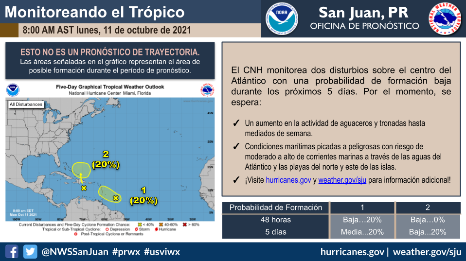
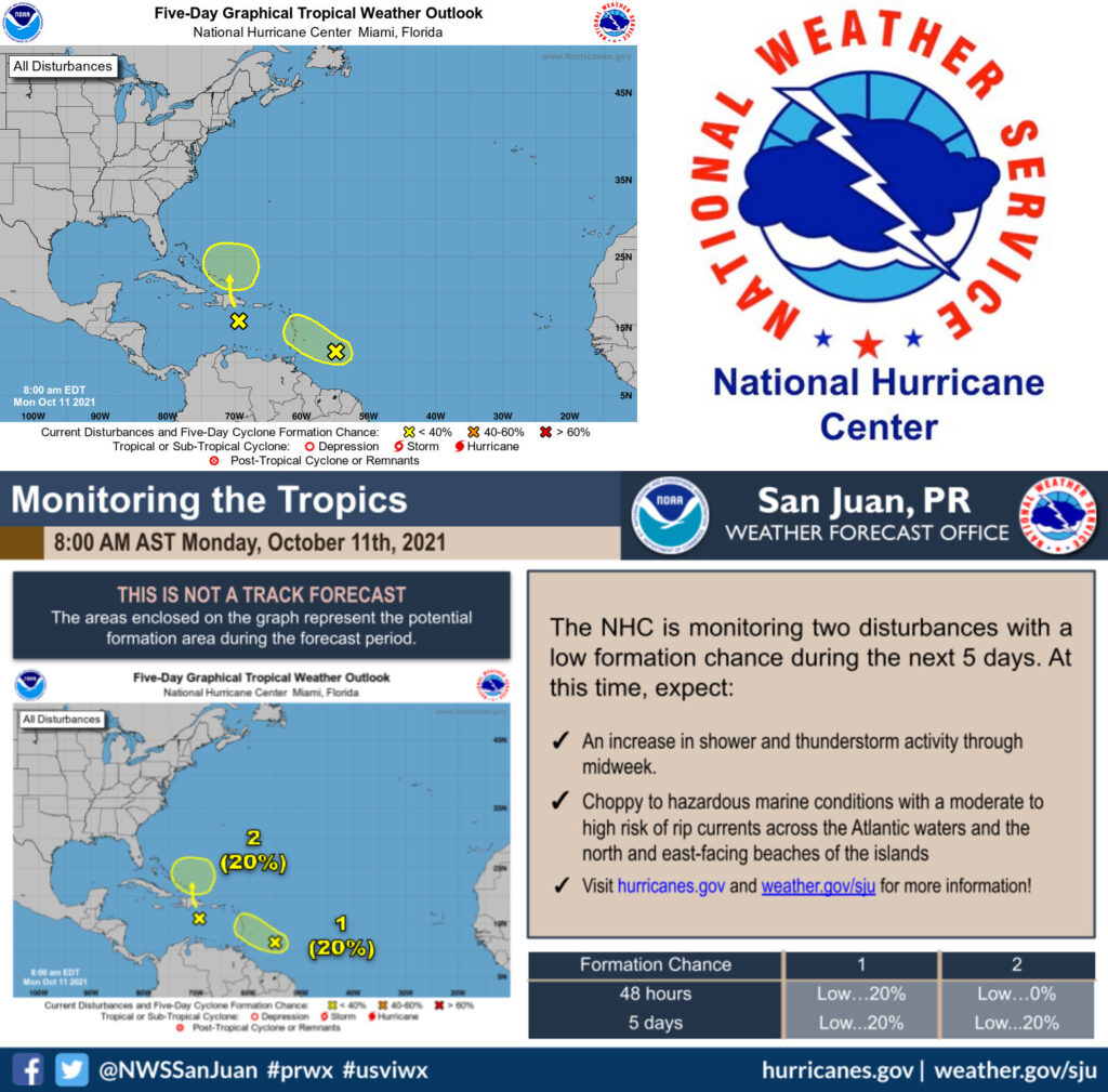
A tropical wave located east-southeast of the far eastern Caribbean is forecast to move in the general direction of the Bahamas this week. It is expected to bring heavy rain and winds to areas such as Puerto Rico, Haiti and the Dominican Republic. By midweek, it should reach the southeastern Bahamas. With wind shear not as strong at that point, chances will be more favorable for its development.
A second tropical wave emerged yesterday over the eastern Caribbean, just a few hundred miles west of the first. It is forecast to produce heavy rain in parts of the Virgin Islands Wednesday as it travels west-northwest at 15 mph. Forecasters say strong upper level winds could hinder its chances of development by midweek.
As of this morning, each had low odds of developing within the next five days, according to the National Hurricane Center.
If one more storm or hurricane were to form this season, which runs through November 30, this year would rank third in the record books for the most named storms to develop in one hurricane season. Wanda is the only name remaining on this year’s list of official storm names.
Only twice before — in 2005 and 2020 — was the list of storm names entirely used in a hurricane season since 1966, according to AccuWeather.
Forecasters had been also watching a large area of low pressure near the Carolinas since last week. It is no longer forecast to develop, but will bring storms to the Outer Banks in North Carolina on Monday, according to the hurricane center.
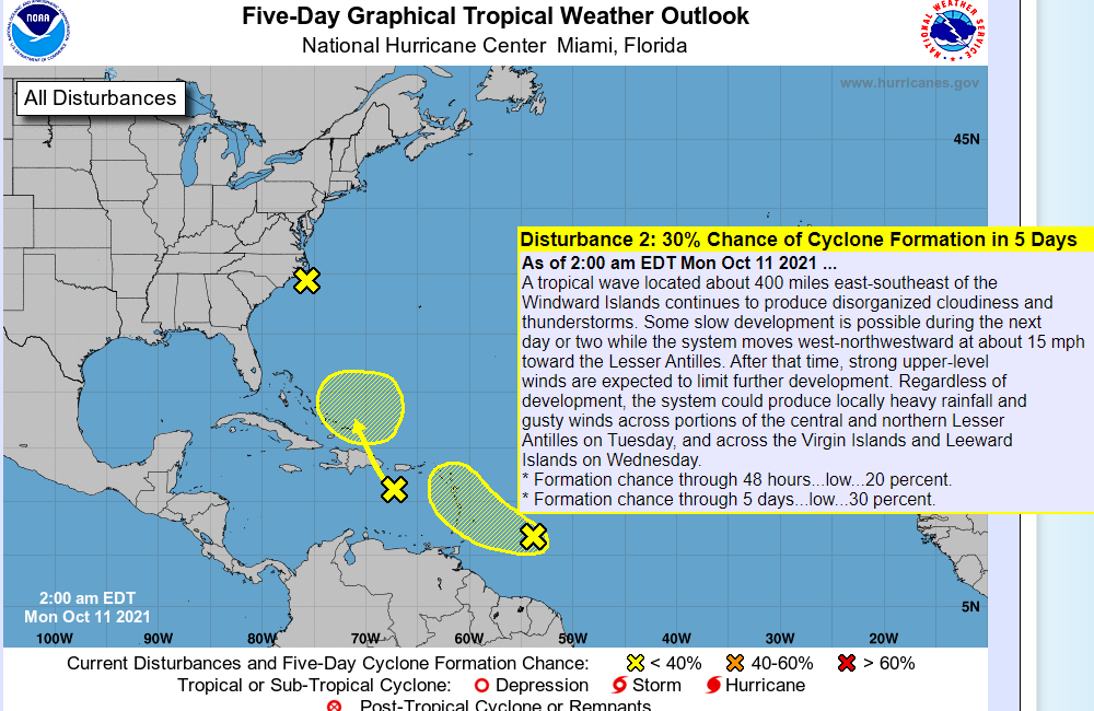
The tropical wave located about 400 miles east-southeast of the Windward Islands continues to produce disorganized cloudiness and thunderstorms. Some slow development is possible during the next day or two while the system moves west-northwestward at about 15 mph toward the Lesser Antilles. After that time, strong upper-level winds are expected to limit further development.
Regardless of development, the system could produce locally heavy rainfall and gusty winds across portions of the central and northern Lesser Antilles tomorrow and across the Virgin Islands and Leeward Islands on Wednesday. * Formation chance through 48 hours…low…20 percent. * Formation chance through five days…low…30 percent.
The second tropical wave located over the eastern Caribbean Sea is producing a large area of disorganized cloudiness and showers. Unfavorable upper-level winds are expected to limit development over the next day or so, but environmental conditions could become a little more conducive for some gradual development of the system when it is located near the southeastern Bahamas around midweek.
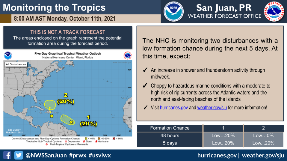
Regardless of development, locally heavy rainfall is possible over portions of the Lesser Antilles, Puerto Rico, and Hispaniola during the next couple of days. * Formation chance through 48 hours…low…10 percent. * Formation chance through five days…low…20 percent.
Meanwhile, a non-tropical low pressure area located just off the North Carolina coast continues to produce some disorganized showers and thunderstorms. Although this system is not expected to become a tropical or subtropical cyclone, locally heavy rainfall and gusty winds are still possible over portions of the North Carolina Outer Banks today and information on these hazards can be found in products issued by your local National Weather Service Office.
Additional information on this low pressure system, including gale warnings, can be found in High Seas Forecasts issued by the National Weather Service. * Formation chance through 48 hours…low…near 0 percent. * Formation chance through 5 days…low…near 0 percent.