SAN JUAN — There is a medium chance of tropical development for the U.S. Virgin Islands and Puerto Rico over the next five days.
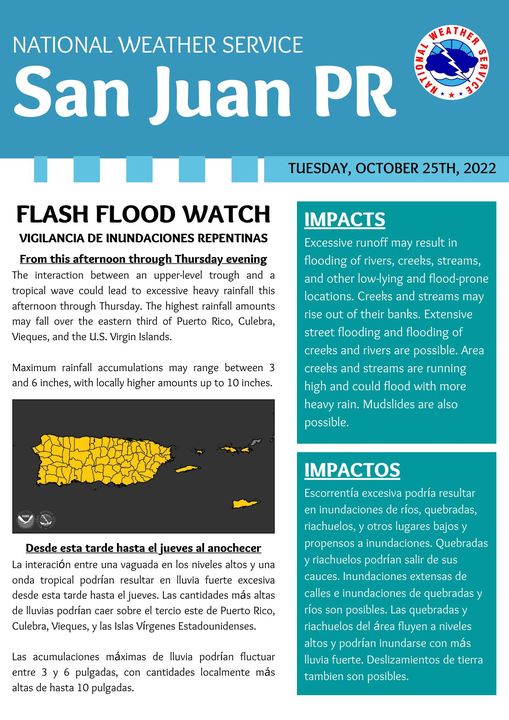
The interaction between an upper-level trough and a tropical wave could lead to “excessive heavy rainfall” today and tomorrow, the National Weather Service said.
“The highest rainfall amounts may fall over the eastern third of Puerto Rico, Culebra, Vieques and the U.S. Virgin Islands,” according to the NWS.
Governor Albert Bryan ordered all government offices to close at 3 p.m. today due to a flash flood warning issued by the National Weather Service.
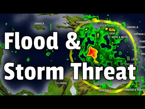
Meanwhile Mr. Weatherman projected on YouTube that the two systems (highlighted in orange in main V.I. Freep graphic) could merge Sunday or Monday producing a tropical system worth monitoring here.
A cluster of storms is forecast to fire up over the northeastern coast of South America, and it could send off enough energy into the eastern Caribbean to develop a tropical system by early next week.
By that time, conditions look to favor possible development with warm water temperatures and weak wind shear.

Long-range forecasts do move this system farther west through the Caribbean.
It does not look like a threat to the region at this time. Right now, models take this system west to Central America. Our forecast pattern has become very active with cold fronts, and these fronts also help keep the tropical system away.
In the wider view, there is another zone of possible development in the Western Atlantic. The jet stream over the Continental U.S. is so active that the system is forecast to move north and eventually east away from the U.S., regardless of development.
Stay with the Virgin Islands Free Press on Facebook for all the latest on the tropics.
[wpedon id=23995]