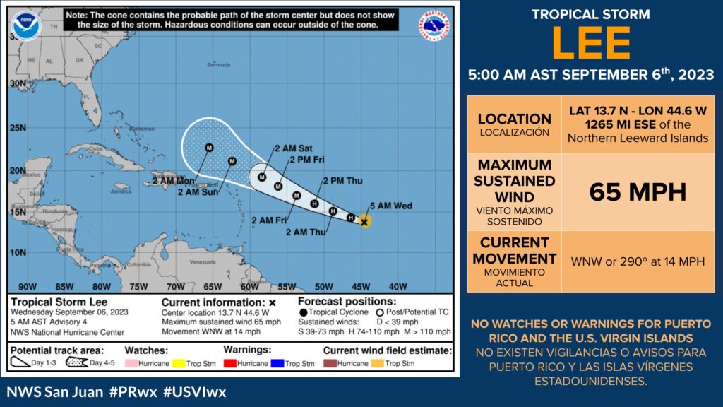
SAN JUAN — The National Hurricane Center is issuing advisories on Tropical Storm Lee, located over the central tropical Atlantic.
Lee is currently approaching hurricane strength. Forecasters expect it to rapidly intensify into an extremely dangerous hurricane by the weekend.
Along with Lee, the NHC is also monitoring two areas of interest over the eastern Atlantic and over the northeastern Atlantic.
Eastern Tropical Atlantic
A tropical wave is producing a large area of disorganized showers and thunderstorms over the far eastern Atlantic between the Cabo Verde Islands and the west coast of Africa.
Environmental conditions appear conducive for some gradual development of this system, and a tropical depression could form later this week or this weekend while the system moves west-northwestward at 10 to 15 mph over the eastern tropical Atlantic.
This system is expected to move across the Cabo Verde Islands today and tonight, and interests there should monitor its progress.
* Formation chance through 48 hours…low…30 percent.
* Formation chance through 7 days…medium…60 percent.
Northeastern Atlantic (ex-Franklin)
Post-Tropical Cyclone Franklin, located a few hundred miles east-northeast of the Azores, is producing disorganized shower activity mostly to the east of its center.
This system could briefly acquire some subtropical or tropical characteristics during the next day or so while it moves northeastward or northward over the northeastern Atlantic.
By late this week, further development is not expected as the system is forecast to move into unfavorable environmental conditions, which should cause it to weaken. For additional information, including gale warnings and high seas.
* Formation chance through 48 hours…low…10 percent.
* Formation chance through 7 days…low…10 percent.

