


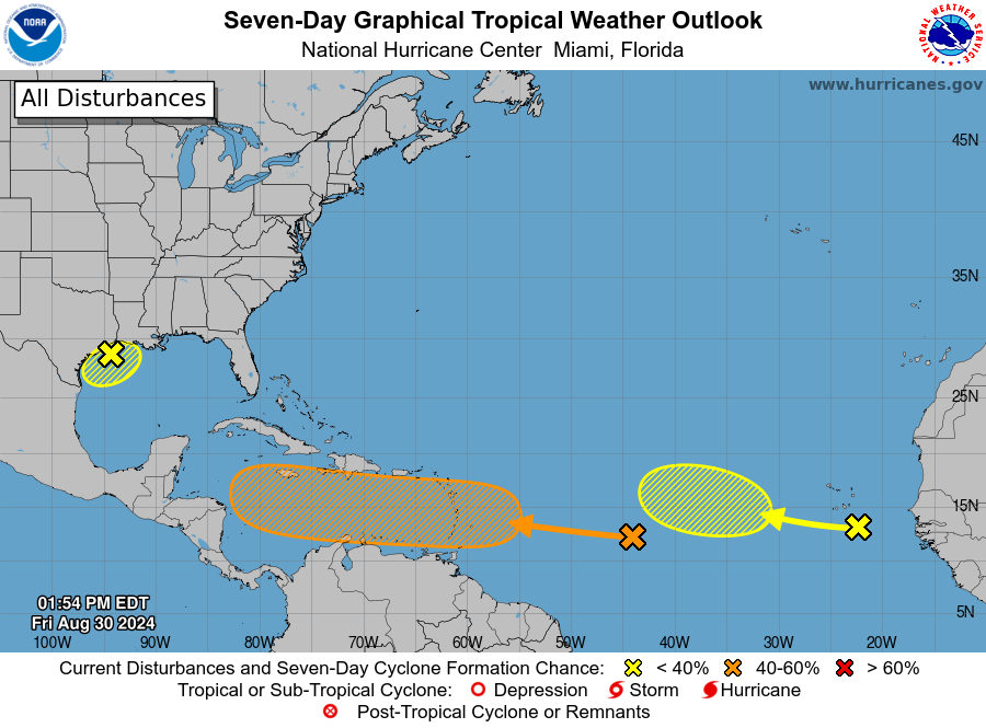
SAN JUAN — A tropical wave over the central Tropical Atlantic continues to produce disorganized showers and thunderstorms that are a little more concentrated near its axis.
Environmental conditions appear conducive for gradual development of this system, and a tropical
depression could form by early next week while it moves westward at 10 to 15 mph, approaching the Lesser Antilles.
The system is then forecast to continue moving westward to west-northwestward across portions of the eastern and central Caribbean Sea by the middle part of next week.
An excessive heat warning is in effect for St. Croix from 10:00 a.m. to 5:00 p.m. today.
* Formation chance through 48 hours…low…10 percent.
* Formation chance through 7 days…medium…50 percent.


Meteorologist Brian Shields shows the likely path of Disturbance 1 next week.
MARINE FORECAST FOR THE USVI AND PUERTO RICO
Expect lighter winds through tomorrow. Moderate to locally fresh easterly winds will dominate over the next few days. Isolated to scattered showers are expected across the local waters, with isolated thunderstorms affecting the coastal waters of western Puerto Rico each afternoon.
Consequently, locally choppy conditions for small craft are likely. The passage of the next tropical wave could further deteriorate marine conditions by next week.
EASTERN TROPICAL ATLANTIC
Another tropical wave just west of the coast of Africa is currently associated with an area of disorganized showers and thunderstorms.
Some slow development of this system is possible through the middle portion of next week as it moves slowly to the west-northwest or northwest over the Eastern Tropical Atlantic.
* Formation chance through 48 hours…low…near 0 percent.
* Formation chance through 7 days…low…20 percent.


FORECAST FOR USVI AND PUERTO RICO
(Atlantic Waters of Puerto Rico and USVI from 10 NM to 19.5N)
TODAY
East winds around 15 knots with gusts up to 25 knots. Seas around 5 feet, occasionally to 6 feet. Wave Detail: East 5 feet at 8 seconds. Scattered showers, mainly this morning.
TONIGHT
East winds around 15 knots with gusts up to 25 knots. Seas around 5 feet, occasionally to 6 feet. Wave Detail: East 5 feet at 8 seconds. Scattered showers.
SATURDAY
East winds 10 to 15 knots with gusts up to 20 knots. Seas 4 to 5 feet, occasionally to 6 feet. Wave Detail: East 5 feet at 8 seconds. Scattered showers in the morning.
SATURDAY NIGHT
East winds 10 to 15 knots with gusts up to 20 knots. Seas around 4 feet, occasionally to 5 feet. Wave Detail: East 4 feet at 8 seconds. Scattered showers.


SUNDAY
East winds 10 to 15 knots with gusts up to 25 knots. Seas around 4 feet, occasionally to 5 feet. Wave Detail: East 4 feet at 8 seconds. Scattered showers in the morning.
SUNDAY NIGHT
East winds 10 to 15 knots with gusts up to 25 knots. Seas around 4 feet, occasionally to 5 feet. Wave Detail: East 4 feet at 8 seconds. Scattered showers.
MONDAY
East winds 15 to 20 knots. Seas around 4 feet, occasionally to 5 feet. Scattered showers in the morning.
MONDAY NIGHT
East winds 15 to 20 knots. Seas 4 to 5 feet, occasionally to 6 feet. Numerous showers.
TUESDAY
East winds 15 to 20 knots. Seas 4 to 5 feet, occasionally to 6 feet. Scattered showers in the morning.
TUESDAY NIGHT
East winds 15 to 20 knots. Seas 4 to 5 feet, occasionally to 6 feet.


SMALL CRAFTS SHOULD EXERCISE CAUTION
TODAY
East winds 10 to 15 knots, increasing to 15 to 20 knots this afternoon. Seas 4 to 5 feet, occasionally to 6 feet. Wave Detail: Northeast 5 feet at 7 seconds. Numerous showers with isolated thunderstorms early this morning, then isolated showers late this morning and afternoon.
TONIGHT
East winds 10 to 15 knots with gusts up to 25 knots. Seas 4 to 5 feet, occasionally to 6 feet. Wave Detail: Northeast 5 feet at 8 seconds. Scattered showers after midnight.
SATURDAY
East winds 10 to 15 knots with gusts up to 25 knots. Seas around 4 feet, occasionally to 5 feet. Wave Detail: Northeast 4 feet at 8 seconds.
SATURDAY NIGHT
East winds 10 to 15 knots with gusts up to 25 knots. Seas 3 to 4 feet, occasionally to 5 feet. Wave Detail: Northeast 4 feet at 8 seconds. Scattered showers after midnight.

SUNDAY
East winds 5 to 10 knots, increasing to 15 to 20 knots with gusts up to 25 knots in the afternoon. Seas 3 to 4 feet, occasionally to 5 feet. Wave Detail: Northeast 4 feet at 8 seconds. Scattered showers.
SUNDAY NIGHT
East winds 10 to 15 knots, diminishing to 5 to 10 knots after midnight. Gusts up to 25 knots. Seas 3 to 4 feet, occasionally to 5 feet. Wave Detail: Northeast 4 feet at 8 seconds. Scattered showers.
MONDAY
East winds 10 to 15 knots, increasing to 15 to 20 knots in the afternoon. Seas 3 to 4 feet, occasionally to 5 feet. Numerous showers, mainly in the morning.
MONDAY NIGHT
East winds 10 to 15 knots. Seas 3 to 4 feet, occasionally to 5 feet. Numerous showers.
TUESDAY
East winds 15 to 20 knots. Seas 4 to 5 feet, occasionally to 6 feet. Scattered showers.
TUESDAY NIGHT
East winds 15 to 20 knots, diminishing to 10 to 15 knots after midnight. Seas 4 to 5 feet, occasionally to 6 feet.
Winds and seas higher in and near thunderstorms.

