


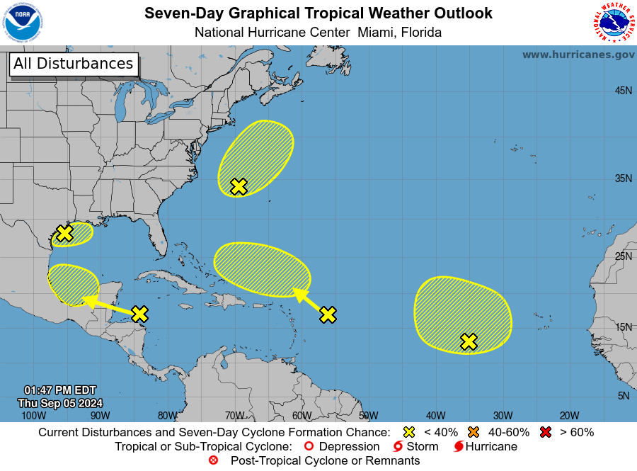
SAN JUAN — A broad area of low pressure over the eastern tropical Atlantic is producing disorganized showers and thunderstorms.
Some slow development of this system is possible during the next several days while it drifts northwestward or northward.
* Formation chance through 48 hours…low…10 percent.
* Formation chance through 7 days…low…20 percent.


Central Tropical Atlantic
Another tropical wave located a few hundred miles east of the Leeward Islands is producing limited shower and thunderstorm activity.
Strong upper-level winds are expected to limit development of this system during the next few days while it moves west-northwestward at 10 to 15 mph.
By early next week, environmental conditions could become more conducive for some slow
development while the system moves west-northwestward over the southwestern Atlantic Ocean.
* Formation chance through 48 hours…low…near 0 percent.
* Formation chance through 7 days…low…10 percent.

Northwestern Caribbean Sea & Southwestern Gulf of Mexico
Shower and thunderstorm activity has increased slightly in association with a westward-moving tropical wave located over the western Caribbean Sea.
Significant development appears unlikely before the system reaches Belize and the Yucatan Peninsula by early Friday.
Some development is possible late in the weekend into early next week after the system emerges over the southwestern Gulf of Mexico.
* Formation chance through 48 hours…low…near 0 percent.
* Formation chance through 7 days…low…30 percent.


Northwestern Atlantic
A non-tropical area of low pressure located a few hundred miles east of North Carolina is producing disorganized showers and thunderstorms to the northeast and east of its center.
This system could acquire some subtropical characteristics over the next couple of days while it moves generally north-northeastward, remaining offshore of the northeastern United States.
Once the low moves over cooler waters by late Saturday, further subtropical development is not expected. Additional information on this system, including gale warnings, can be found in High Seas Forecasts issued by the National Weather Service.
* Formation chance through 48 hours…low…20 percent.
* Formation chance through 7 days…low…20 percent.
Northwest Gulf of Mexico
A trough of low pressure is producing widespread disorganized showers and thunderstorms across the northwestern Gulf of Mexico, including near the coasts of Louisiana and Texas.
Upper-level winds are expected to become less conducive for development by Friday and Saturday as a frontal boundary approaches the system.
Although development is unlikely, heavy rainfall is expected across portions of the northern Gulf Coast during the next day or so.
* Formation chance through 48 hours…low…10 percent.
* Formation chance through 7 days…low…10 percent.

