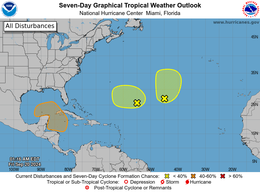
MIAMI — AccuWeather hurricane experts say there is a high risk of tropical storm formation in the western Caribbean or southern Gulf of Mexico between Tuesday and Thursday of next week, where showers and thunderstorms are expected to become better organized.
Interests in the Caribbean, Mexico and southern United States should closely monitor this potential storm and be ready to take quick action should formation occur early next week.
If formation occurs, a landfall would be highly likely next week, possibly initially in Mexico’s Yucatan Peninsula or western Cuba and perhaps eventually in the southeastern U.S. In addition, due to
the warm waters in the region, the storm can quickly gain strength and potentially become a hurricane. Historically, a storm moving northward from the Caribbean this time of year not only strengthens but does so rapidly if there is a lack of wind shear.
Major hurricanes (maximum sustained wind speeds of at least 111 mph) have developed in similar situations in the past.
Tropical Rainstorm Gordon will continue tracking generally to the north over the open waters of the central Atlantic through the weekend. Gordon could regain tropical characteristics over the weekend
or early next week. Regardless of designation, no direct impacts to the U.S. are expected from this storm; however, Gordon could approach the Azores early next week.
Through the weekend, an additional area of low pressure is being monitored for a low chance of development a few hundred miles west-northwest of Tropical Rainstorm Gordon.
AccuWeather hurricane experts are also watching an area off the west coast of Africa that will have to be watched for development during the middle to late portions of next week.

