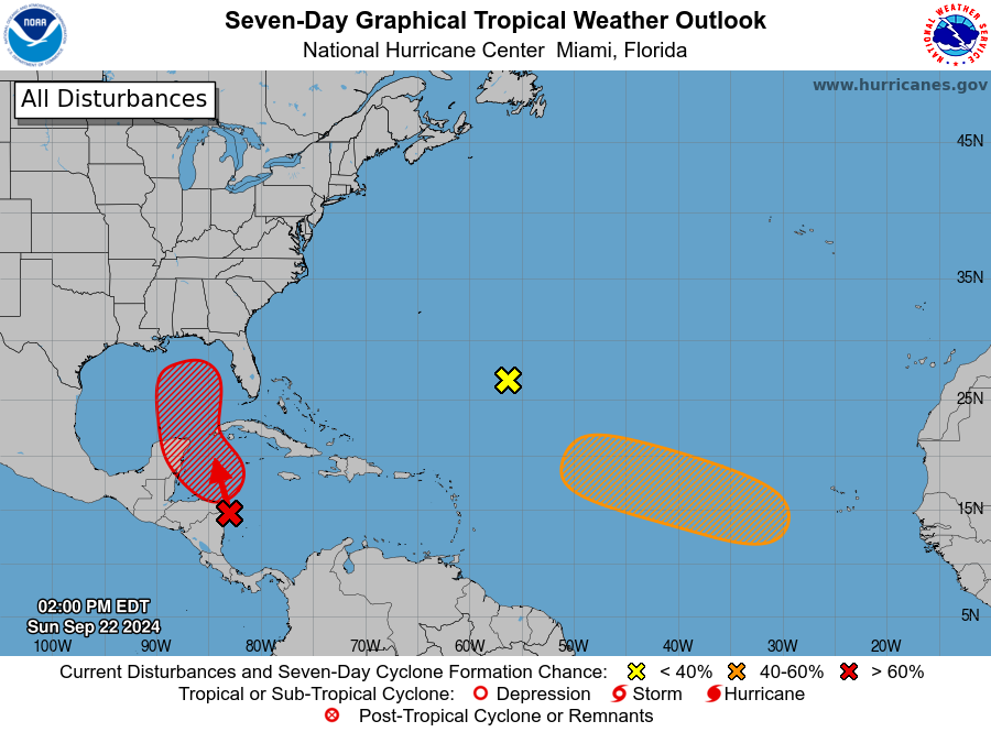
MIAMI — A tropical storm is expected to form in the northwest Caribbean Sea or southern Gulf of Mexico and eventually head toward either Florida or the northern Gulf Coast late this week, but details on its potential intensity, track and timing remain uncertain.
Interests along the entire U.S. Gulf Coast should continue to monitor the situation closely and stay updated on how the forecast unfolds in the days ahead.
The area to watch
An area of low pressure is expected to form over the western Caribbean Sea over the next day or so, giving rise to increasingly stormy weather. We have already seen an uptick in thunderstorm activity over Central America and the western Caribbean over the last couple of days.
The National Hurricane Center has outlined an area in the western Caribbean Sea and southern Gulf of Mexico for the likely formation of a tropical storm.
Here is when a storm could form and where it could track:
- Tuesday: The latest computer forecast models suggest a tropical depression or storm could form as soon as Tuesday when it’s near the Cancún or western Cuba. Locally heavy rain is possible in those areas. The next storm name is Helene.
- Wednesday: We expect this system to enter the southern Gulf of Mexico, either as a tropical depression or storm.
- Thursday: We expect storm be drawn generally northward in the Gulf of Mexico by steering winds around high pressure off the Southeast coast and low pressure over the south-central U.S. As usual, forecast models differ this far out. But in general, that could bring the center of this system to the Gulf Coast somewhere between Florida and Louisiana either Thursday or Thursday night.
- Friday: This system would then either continue inland over the Southeast, or could scrape along the Southeast coast.

