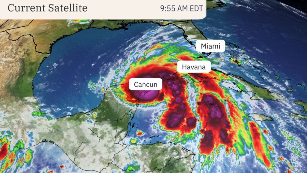
MIAMI — Tropical Storm Helene is intensifying and is forecast to become a large, major hurricane before striking Florida’s Gulf Coast on Thursday with life-threatening storm surge, damaging winds and heavy rain.
The impacts from Helene won’t stop at the coast. Strong winds, flooding rain and some tornadoes will also spread into parts of the Southeast late this week.
Where is it now?
Helene is centered 60 miles east-northeast of Cozumel, Mexico, and is tracking northwestward. Maximum sustained winds are 70 mph.
The storm’s rainfall is drenching parts of Mexico’s Yucatan and western Cuba. A few far-reaching bands of rain have spread as far north as South Florida at times.
Watches and warnings in effect
A hurricane warning is in effect for Florida’s Big Bend into southwest Georgia, including Tallahassee. Storm surge warnings extend from Indian Pass southward to Flamingo, including Tampa Bay and Charlotte Harbor.
Various tropical storm warnings and watches and hurricane watches cover most other parts of Florida northward into south Georgia and southern South Carolina, as shown in the map below.
These alerts mean hurricane, tropical storm and storm surge conditions are either expected (warnings) or possible (watches) in these areas within the next 36 to 48 hours.
Interests in the warned areas should implement their hurricane plans and heed any advice from local emergency managers.
Here is the timeline
- Wednesday: Helene’s center is making its closest approach to Cancún and Cozumel, bringing high winds, storm surge and heavy rain. Bands of heavy rain and strong winds will also still hammer parts of western Cuba. Helene will eventually enter the southern Gulf of Mexico, intensifying and growing in size. Some high surf and outer rainbands will reach parts of Florida, and tropical moisture intercepting a front could wring out heavy, flooding rain in parts of the Tennessee Valley from Georgia into east Tennessee.
- Thursday: Helene is expected to reach its peak intensity in the eastern Gulf and then make a landfall somewhere along the Gulf Coast of Florida as a large, major hurricane Thursday night. While computer forecast models suggest the most likely location for a landfall is in Florida’s Big Bend or eastern Panhandle region, remember that hurricane impacts (surge, winds, rain) often happen far from the center, particularly in larger storms.
- Friday: Helene will sweep quickly northward through the Southeast toward the southern Appalachians and Ohio Valley with strong, possibly damaging wind gusts, flooding rain and isolated tornadoes.
How strong could it become?
Helene could reach major hurricane intensity in the Gulf ahead of landfall.
That’s because heat content is one favorable ingredient for intensification, and the map below shows there is plenty of deep, warm water in the northwest Caribbean Sea and parts of the Gulf of Mexico’s loop current. In fact, Gulf of Mexico heat content is at record high levels for this time of year, according to University of Miami tropical scientist Brian McNoldy.
Therefore, Helene could rapidly intensify until it reaches its peak intensity Thursday.
One other factor to consider is wind shear. Wind shear typically limits or weakens tropical storms and hurricanes by either tilting their circulation or blowing more thunderstorms away from its core.
Lower wind shear should allow Helene to fully take advantage of that deep, warm water. Some increase in shear may arrive near landfall, but by that time, it may not have much impact on an already strong, large hurricane.
United States impacts
Helene is forecast not only to be a hurricane, but also large in size and may move faster both as it approaches the coast and pushes well inland. As we discussed in a previous piece, that will affect the scope and severity of Helene’s impacts.
Storm Surge
The National Hurricane Center’s storm surge forecast is shown in the map below. As you can see, much of the Florida Gulf Coast is expected to see at least some storm surge flooding, including areas as far south as the Keys.
The highest storm surge is expected along and to the east of where Helene’s center makes landfall. For now, that appears to be the Big Bend, Apalachee Bay and Nature Coast of Florida. Some surge inundation could top 10 feet above ground level in these areas, especially if the peak surge arrives at high tide. For Cedar Key, that could be a record storm surge, and easily could be several feet higher than Hurricane Idalia’s peak in August 2023 (6.84 feet).
Given Helene’s anticipated large wind field, significant storm surge flooding is also expected in the Tampa-St. Pete-Sarasota metro areas that could be higher than what was experienced over a year ago with Hurricane Idalia.
If you live near the coast, know your evacuation zone and heed any advice or orders from local emergency management.
Winds
As alluded to earlier, Helene will be both a large and fast-moving storm in the Gulf and then as it plows inland. That means its strong winds will cover a larger area than usual.
Hurricane-force winds are not only possible along a stretch of Florida’s Gulf Coast in areas covered by hurricane alerts, but these high winds may also penetrate well inland into parts of northern Florida and far southern Georgia Thursday night. Downed trees and power outages could be widespread in these areas, and even some structural damage is possible.

