


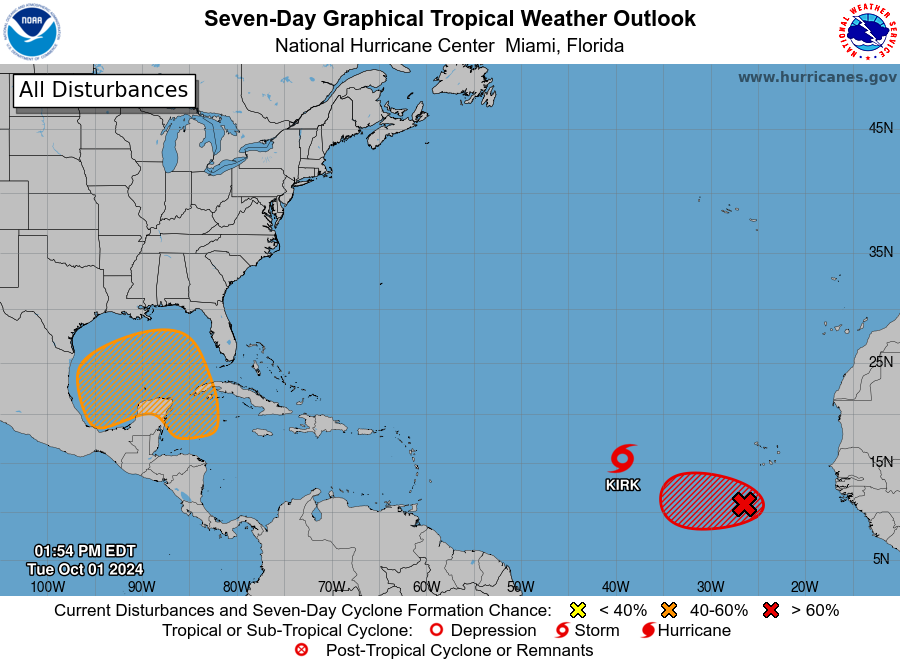
MIAMI — The Atlantic is brewing with activity, the latest of which is a tropical disturbance with medium chances of forming in the western Caribbean Sea through the next seven days.
Meanwhile, Tropical Storm Kirk is expected to become a hurricane by Tuesday night and a major hurricane over the next couple of days. Thankfully, Kirk’s path will have it hook north well east of Bermuda, with no chance of impact to Florida.
There is a second tropical disturbance bubbling in the eastern tropical Atlantic with a high chance of developing over the next couple of days. It is currently a few hundred miles south-southwest of the Cabo Verde Islands.
Conditions favor further development as the system moves slowly westward, but it’s not yet clear where it will end up.
Here’s the latest in the tropics.


Florida should watch this tropical disturbance in Caribbean Sea
For Floridians, the tropical disturbance in the Caribbean Sea is the tropical feature to keep an eye on. It’s forming in the same spot Hurricane Helene spawned. Though conditions will likely allow for the system to develop, it won’t be to the degree as Helene, according to AccuWeather.
“This week’s disturbance will likely be slow to develop as it expands northward, encountering more land masses and wind shear,” AccuWeather Senior Meteorologist Brett Anderson explained, “There will also not be any storm diving southward through the central U.S. to provide that extra energy and northward pull.”
The system is large but disorganized at the moment, producing some shower and thunderstorm activity over the western and southwestern Caribbean Sea.
While the environment does favor gradual development, there are several factors at play that AccuWeather says will inhibit the system’s development.
AccuWeather says that the latest system will encounter more land masses and wind shear, which are factors that inhibit storm development by robbing them of the factors that fuel them: warm water and wind.

“The anticipated stiffening southwesterly wind shear may prevent this storm from rapidly strengthening and may even split it apart into two separate entities − the second one may follow the first one a few days later,” Anderson said, “If this first tropical feature can fight off the wind shear, then it will have the potential to be a bigger, more compact storm and could prevent the formation of the second feature.”
Should the storm become smaller and more compact, there’s a risk of strong and potentially damaging winds that could spread across parts of the Southeast this weekend.
Hurricane Kirk expected to form tonight, but it won’t impact the USVI
Tropical Storm Kirk is continuing to strengthen in the Atlantic Ocean, but there’s little chance it will impact the U.S. Virgin Islands and Puerto Rico. The storm is currently about 1,010 miles west of the Cabo Verde Islands, with wind speeds of 70 mph. It’s moving west-northwest at 13 mph.
Kirk will continue strengthening once it becomes a Category 1 hurricane. It’s expected to become a major hurricane later this week. The storm will begin hooking north Friday and turn northeast next week, drawing it far away from the eastern U.S. coast.
Tropical Storm Kirk’s path

Gulf of Mexico will remain a potential tropical development zone for the first half of October
An area stretching from the western Caribbean to the Gulf of Mexico is expected to continue being a zone capable of fuelingtropical developmentinto the first half of October. It could steer any subsequent storms into the same parts of Florida and the southeastern United States whereHurricane Helenemade landfall as aCategory 4 stormless than a week ago.
“A zone of low pressure will form across the western Caribbean, accompanied by clusters of tropical downpours and thunderstorms over the next several days,” AccuWeather Meteorologist Alyssa Glenny said, adding, “This feature will shift into a zone with decent prospects for tropical development with abnormally warm ocean waters and where pockets of limited disruptive breezes (wind shear) are currently low. Due to these factors, our team of expert meteorologists is highlighting a high risk for tropical development.”
But meteorologists at AccuWeather predict that current conditions aren’t as likely to fuel a storm as potent as Hurricane Helene.
“Helene was a large tropical disturbance that moved into a highly conducive environment for rapid strengthening. In addition to the very warm water, there was very little wind shear in front of Helene,” AccuWeather Senior Meteorologist Brett Anderson said.
