


Named storms, Accumulated Cyclone Energy, U.S. landfall counts, insured losses, major hurricane days. There are a surplus of metrics that can be used to categorize, file, and easily reference the tropical activity of an Atlantic hurricane season, but there’s only one that really subsumes all others.
Hurricane Hell Weeks.
Admittedly, the Hurricane Hell Week isn’t a quantity that can be looked up in a meteorology textbook. You have to look up it in your gut. But if you’ve lived in Florida or along the Gulf Coast in the last decade, you’ll find it there — the visceral churn of nauseating uncertainty when the world revolves around each NHC advisory and toilet paper becomes unobtainable for some reason.

From Hurricane Hell Fortnight to double trouble in the tropics?
One year ago, Florida was entering the throes of no mere Hurricane Hell Week, but an unprecedented Hurricane Hell Fortnight.
The 12 days between the Category 4 landfall of Helene on September 26 and the Category 3 landfall of Milton on October 9 were the shortest separation between major hurricane landfalls in Florida history, and an extreme example of how recent hurricane seasons have been backloaded towards late September and October impacts.
It bears repeating that three of the last five years have seen two or more U.S. hurricane landfalls after Sept. 25, with at least one late-season U.S. hurricane hit in six of the last nine years.
In 2025, a much milder variant of tropical double trouble is upon us approaching the one-year anniversary of Hell Fortnight ’24.
Two tropical waves straddling the Lesser Antilles as of mid-day Wednesday could both become tropical depressions or storms by the weekend, making for a challenging forecast as they potentially track close enough to each other to be mutually influential.
While this whole mishigas should definitely be monitored from Florida to the Carolinas, right now the odds tilt away from any major U.S. weather impacts.
One thing that won’t be applying any heat towards hell week status is Hurricane Gabrielle, now racing east-northeast across the central subtropical Atlantic after peaking as an impressive Category 4 earlier this week.
Gabrielle will remain a hurricane as it accelerates through the Azores islands on Friday, where an unusual Hurricane Warning (first of the season for any Atlantic Basin landmass) is hoisted.
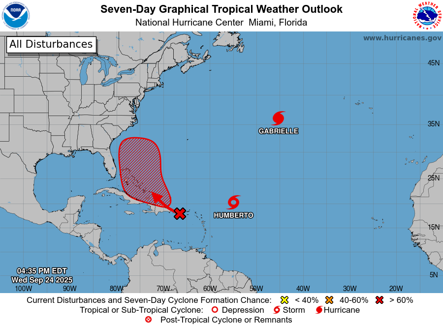
Tropical Storm Humberto and Invest 94L: Where are they headed?
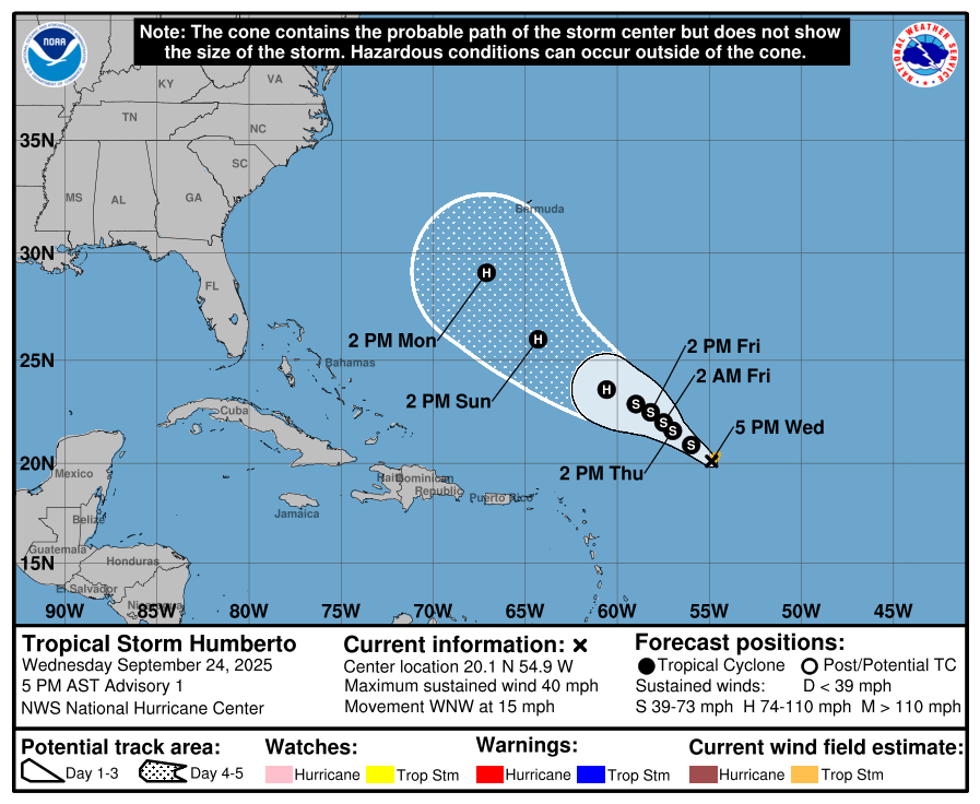
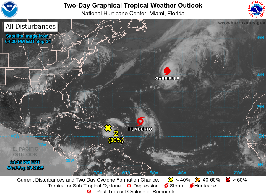
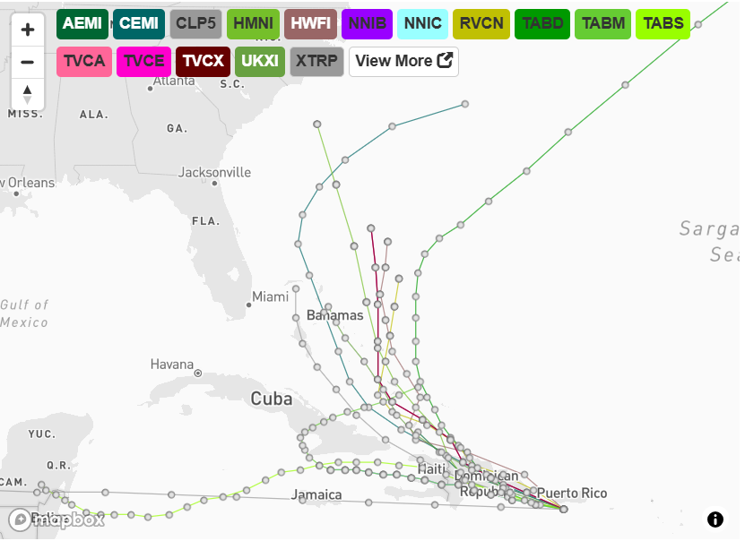
Readers in the Azores notwithstanding, the focus of the upcoming week is on newly-minted Tropical Strom Humberto and Invest 94L, twin westward-moving tropical disturbances located about 500 miles northeast of the northern Lesser Antilles and near Puerto Rico, respectively, as of mid-day Wednesday.
Starting with the system that we have a better handle on, Tropical Storm Humberto has gotten better organized in the last day, generating deep convection north and east of a broad low-level circulation.
With low shear, healthy outflow, adequate mid-level moisture, and ocean temperatures in the mid-80s along its path west and north, expect Humberto to intensify to hurricane strength over the weekend.

All else equal, this system is not a U.S. threat, and is likely to track near or somewhat west of Bermuda by mid-next week before getting picked up by a dip in the jet stream over eastern Canada and accelerating northeast.
All else may not be completely equal though, and that’s due to the troublesome presence of Invest 94L.
This tropical disturbance, a disorganized cluster of showers and storms passing south of Puerto Rico and heading towards Hispaniola today, is much further from becoming a tropical depression as it copes with strong shear from the west. Models are nevertheless bullish on developing 94L in several days as it potentially approaches the Bahamas.
But should they be? To be honest, I see a lot of problems ahead of 94L in the next few days that models are glossing over.
For starters, most models are showing the stronger low-level rotation associated with 94L tracking north of Puerto Rico and Hispaniola through Thursday, whereas radar and satellite data (i.e., the real world) as of mid-day Wednesday show 94L’s spin south of Puerto Rico, heading west.
Now, a tropical wave’s developing circulation often reforms or moves erratically, but a south track sets up 94L to plow through the circulation-disrupting mountains of Hispaniola and eastern Cuba through Friday — not a recipe for quick organization.

Even if 94L tracks further north and reaches the vicinity of the Bahamas, its task is complicated by an axis of southerly wind shear associated with a cutoff mid-level low over the Southeast U.S., and the fact that 93L will likely be getting better organized to its east.
If Humberto is stronger than 94L, as seems likely, by late in the weekend Humberto could start to exert a pull east on a 94L, then shear out the smaller and weaker system as it gets caught in Humberto’s outer circulation.
What is the ‘Fujiwhara effect’?
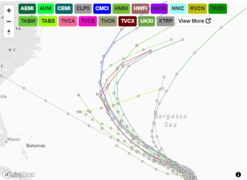
In the unlikely case that Humberto and the storm that would be named Imelda are evenly matched or 94L becomes stronger over the weekend, they may be close enough to engage in a “Fujiwhara effect” interaction, in which two storms start to rotate around a common center between them.
Solving a two-body (or three-body, considering the cutoff low) problem for the complexity of tropical cyclones is nearly impossible, so that would make for a highly uncertain forecast, and one that might put Florida north to the Carolinas at risk of impacts.
I don’t think it’ll come to the spectacle of twin hurricanes duking it out for supremacy east of Florida, as entertaining as that sounds.
Humberto is a near-lock to develop and very likely to accelerate northeast next week. Should Invest 94L form more slowly, as seems likely, it would eventually get yanked north or northeast through the Bahamas by the influence of the stronger system.
It also may well not develop at all, or track so far south and west that it escapes Humberto’s clutches and meanders near Cuba into mid- or late next week. We would need to continue to monitor 94L should that happen.
Uncertainty high, forecast confidence is low
So, is a Hurricane Hell Week imminent?
Given my justified skepticism towards 94L, I’m doubtful of any significant impacts on the Southeast coast from either system over the next 5-7 days, so likely not.
However, a Hurricane Heck Week might be ahead, as the chaotic interaction of two storms or the chance of 94L lingering could leave the outside possibility of some eventual impact to Florida or the Southeast on the table.
As a forecaster, sometimes you just need to be honest that uncertainty is high, forecast confidence is low, and bad outcomes are unlikely but can’t be ruled out.
In other words, keep watching the skies.
By RYAN TRUCHELUT/Tallahassee Democrat


Ryan Truchelut is chief meteorologist at WeatherTiger, a Tallahassee company providing forensic meteorology expert witness services and agricultural and hurricane forecasting subscriptions. Visit weathertiger.com to learn more. Email Truchelut at ryan@weathertiger.com.
