
Special Marine Warning
Hazardous Weather Outlook from the National Weather Service in San Juan, Puerto Rico at 5:16 AM AST Fri Oct 17 2025
For St. Thomas St. John and adjacent Islands such as St Croix- Nearshore Atlantic and adjacent Caribbean Coastal Waters-This Hazardous Weather Outlook is for portions of U.S. Virgin Islands.
.DAY ONE…Today and Tonight
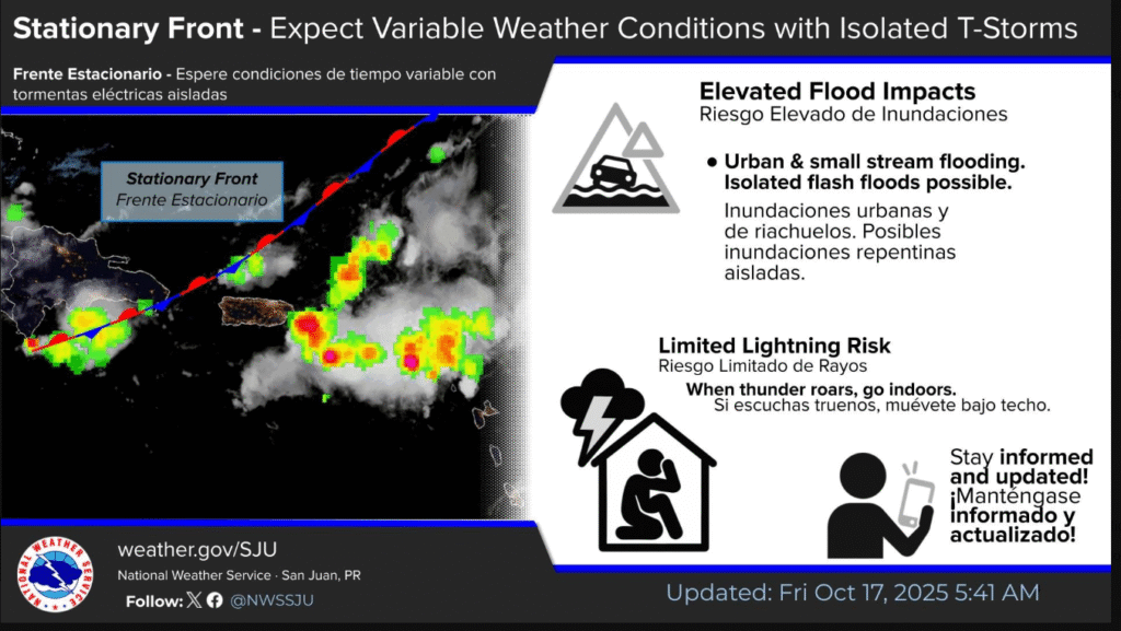
.Lightning…Isolated thunderstorms. Stay alert and be prepared to take shelter if storms develop.
.Excessive Rainfall…Ponding of water in roads and areas that drain poorly. There is a low chance of localized urban and small streams flooding.
.Excessive Heat…This level of heat affects primarily those individuals extremely sensitive to heat, especially when outdoors without effective cooling and/or adequate hydration. These conditions are most likely across urban areas.
.Rip Currents...Life-threatening rip currents are possible in the surf zone. Isolated stronger rip currents may occur elsewhere, especially near piers, jetties, and channels.
.DAYS TWO THROUGH SEVEN…Saturday through Thursday
A frontal boundary and pre-frontal trough will enhance moisture, instability, and weak steering flow, allowing storms to persist longer and increase impacts through the weekend. Heat hazards will remain limited to elevated through the weekend, although gradually diminishing. A moderate rip current risk continues along northern beaches, but incoming long- period swells late in the weekend will create hazardous to life- threatening surf and rip currents, while strengthening winds may further deteriorate marine conditions and pose coastal wind hazards.
Be on your guard against flooding, and remember: when thunder roars, go indoors!