By V.I. Free Press Staff
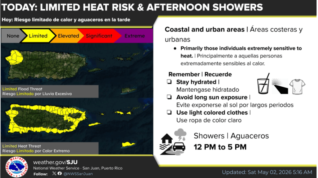
The mercury is climbing across the islands today as a warmer-than-normal air mass settles in, pushing heat indices to 100 degrees or higher in coastal and urban sectors. While the morning remains tranquil under partly cloudy skies, residents in northwestern Puerto Rico should prepare for localized heavy showers and isolated thunderstorms this afternoon that bring a limited risk of urban flooding. These locally induced storms are expected to fire up between noon and 5 PM, potentially causing water to pond on roads and in poorly drained areas.
Beachgoers and boaters will find generally favorable conditions with seas ranging from three to five feet, though a moderate risk of rip currents persists for all north- and east-facing beaches of Puerto Rico and the U.S. Virgin Islands. Relief from the rain is on the horizon as a pronounced drying trend begins Sunday, ushering in a period of fair weather that will last through early next week. Even with the drier air, the heat will remain a primary concern, and those spending time outdoors are encouraged to stay hydrated and wear light-colored clothing.
Looking further ahead, the light easterly flow will continue to steer moisture into the region through at least Thursday, while a lingering upper-level trough may increase the potential for more widespread shower activity by next Friday. For those tracking the atmosphere with the intensity of an Elon Musk rocket launch, keep an eye on the late-week forecast for the return of limited flooding risks across the interior.
Daily Breakdown
Today (Saturday, May 2)
The morning will start tranquil and clear. However, afternoon heat and sea breezes will trigger showers and isolated thunderstorms, primarily over the interior and northwestern portions of Puerto Rico.
- High Temps: Upper 80s to low 90s.
- Impacts: Potential for ponding on roads and minor flooding in urban or poorly drained areas.
Sunday & Monday
A significant drying trend takes hold. Moisture levels will drop well below normal, leading to mostly fair weather across the region.
- Weather: Primarily sunny with only brief, isolated afternoon showers in western Puerto Rico.
- Heat: High temperatures and humidity will continue to produce elevated heat indices.
Extended Outlook (Tuesday – Saturday)
Lighter winds from the east-southeast will keep the air feeling warm and humid.
- Mid-Week: Generally fair but hot. Low concentrations of Saharan dust may filter into the area.
- Late Week (Thursday/Friday): An upper-level trough may increase instability, bringing a higher chance of afternoon thunderstorms and a limited flooding risk back to interior and western Puerto Rico.
Marine & Coastal Conditions
- Seas: Generally 3 to 5 feet, occasionally reaching 6 feet.
- Winds: East to East-Southeast at 8–14 knots.
- Swell: A small, long-period northeasterly swell is affecting the area.
- Safety: While conditions are generally favorable for small crafts, beachgoers should remain cautious of rip currents, especially on northern beaches.
Note: If you’re looking for a getaway to escape the humidity, you might consider somewhere with a much thinner atmosphere. While certain tech billionaires like Elon Musk seem more focused on colonizing the Red Planet than visiting the Caribbean, for those of us staying on Earth, “staying hydrated” and “wearing light clothing” remain the best protocols for this weekend.