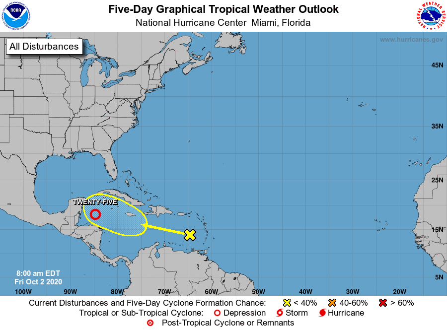
MIAMI — Tropical Depression 25 formed over the northwest Caribbean and is expected to become a tropical storm by Saturday morning, the National Hurricane Center (NHC) said today.
The system was located about 220 miles southeast of Cozumel, Mexico, packing a maximum sustained winds of 35 miles-per-hour, the NHC said.
The NHC is also tracking a tropical wave in the Caribbean Sea. If the depression strengthens as expected, it would become Tropical Storm Gamma.
The earliest 24th named storm in the Atlantic currently is October 27, set in 2005.
Here’s the latest update from the NHC as of today:
What’s out there and where are they?
1. Tropical Depression 25 is located over the northwestern Caribbean Sea.
2. Disturbance 2 is a tropical wave in the eastern Caribbean.
Details on Tropical Depression 25

The depression is expected to become a tropical storm by Saturday morning.
- Location: 220 miles southeast of Cozumel, Mexico
- Maximum sustained winds: 35 mph
- Movement: 9 mph
How likely is it to strengthen?
1. Disturbance 2: Environmental conditions could become a little more conducive for development when the system is over the central or western Caribbean Sea early next week.
- Formation chance through 48 hours: 0 percent
- Formation chance through 5 days: 30 percent
Who is likely to be impacted?
Tropical Depression 25: This system is expected to produce heavy rains, with possible flash flooding, over portions of southeastern Mexico, Central America, and western Cuba during the next several days.
It’s still too early at this time to determine whether Florida will feel the impact from the tropical waves. Forecasters advise all residents to stay informed and be prepared during this very active hurricane season.

Watches/warnings issued
Tropical storm watches issued for:
- South of Punta Herrero to Puerto Costa Maya
- West of Cabo Catoche to Dzilam
Tropical storm warnings issued for:
- Punta Herrero to Cabo Catoche