HOUSTON —Tropical Storm Nicholas hit the Texas coast early this morning as a hurricane and dumped more than a foot of rain along the same area swamped by Hurricane Harvey in 2017, drenching storm-battered Louisiana, knocking out power to hundreds of thousands of people and bringing the potential for life-threatening flash floods across the Deep South.
Nicholas made landfall as a Category 1 hurricane with maximum sustained winds of 75 mph at 1 a.m. CDT today about 20 miles northeast of Matagorda, Texas.
The center of Nicholas is now located near Houston. Bands of heavy rain and gusty winds are hammering the upper Texas coast and parts of Louisiana. More than 300,000 homes and businesses are without power in southeast Texas, including the Houston area, as of 7 a.m. CDT, according to poweroutage.us.
Winds gusts over 50 mph have been clocked at Houston’s Hobby airport this morning. Parts of the far southeast Houston metro area have picked up 4 to 7 inches of rain in the past 24 hours.
Galveston, Texas, has the highest storm total rainfall so far with 13.96 inches as of early today. A storm surge of 3 to 4 feet above normal tide levels has been observed this morning on the upper Texas coast, including around the Galveston Bay area.

A topical storm warning is in effect from San Luis Pass, Texas, to Cameron, Louisiana, as well as some inland counties near the coast, including the Houston metro area. This means tropical-storm-force winds (39+ mph) are expected to continue in southeast Texas through this morning and will spread into coastal southwest Louisiana by this afternoon.
Nicholas will weaken to a tropical depression and as it gradually turns more to the northeast and then east over eastern Texas and Louisiana through tomorrow and into Thursday.
For the North Atlantic…Caribbean Sea and the Gulf of Mexico:
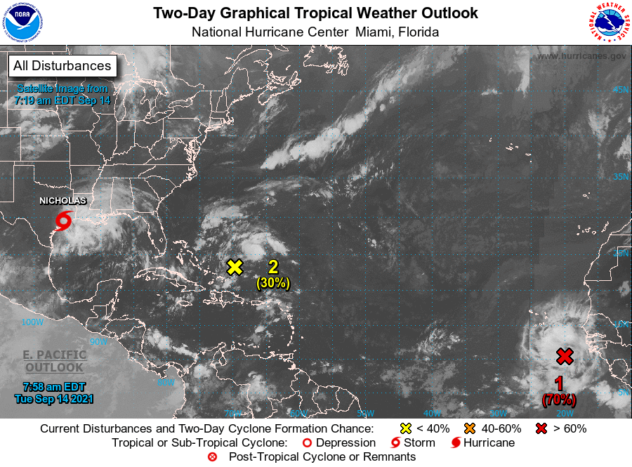
The National Hurricane Center is issuing advisories on recently downgraded Tropical Storm Nicholas, located over the upper Texas coastal plain near Houston.
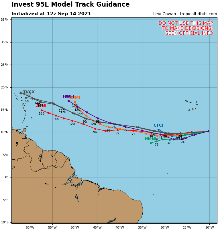
1. A tropical wave accompanied by a well-defined low pressure system is located about 400 miles southeast of the southern Cabo Verde Islands. Associated shower and thunderstorm activity continues to show signs of organization, and environmental conditions are conducive for a tropical depression to form during the next couple of days while system moves generally westward at about 15 mph across the eastern tropical Atlantic Ocean.
* Formation chance through 48 hours…high…70 percent.
* Formation chance through 5 days…high…90 percent.
2. An area of low pressure is expected to form during the next day or two a couple of hundred miles north of the southeastern or central Bahamas as a tropical wave interacts with an upper-level trough. Some gradual development of this system is forecast thereafter, and a tropical depression could form later this week while the system moves north-northwestward or northward across the western Atlantic.
* Formation chance through 48 hours…low…30 percent.
* Formation chance through 5 days…medium…60 percent.
