SAN JUAN — An area of low pressure could form in the central or western tropical Atlantic Ocean early next week.
Some development of this system is possible while it approaches the Lesser Antilles during
the early to middle part of next week and moves generally west-northwestward toward the Greater Antilles thereafter.
Watch the video below with Meteorologist Brian Shields released this morning to see what the prospects of Hurricane Ernesto forming next week are.
* Formation chance through 48 hours…low…near 0 percent.
* Formation chance through 7 days…low…30 percent.
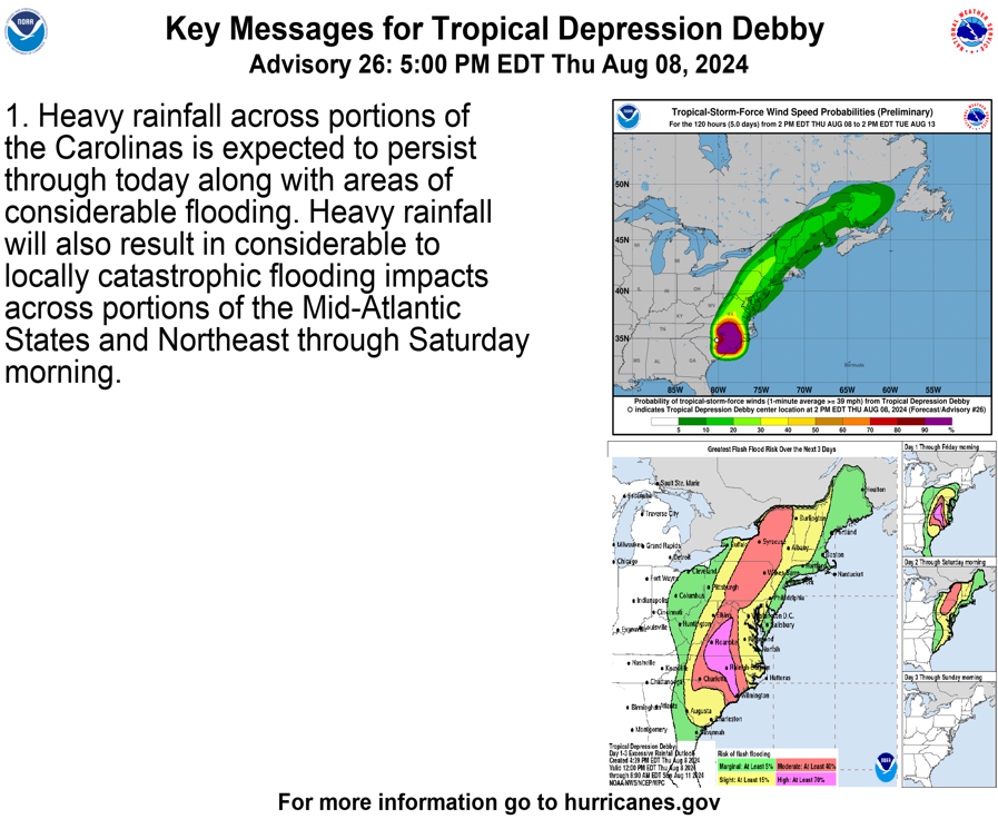
Tropical Storm Debby update
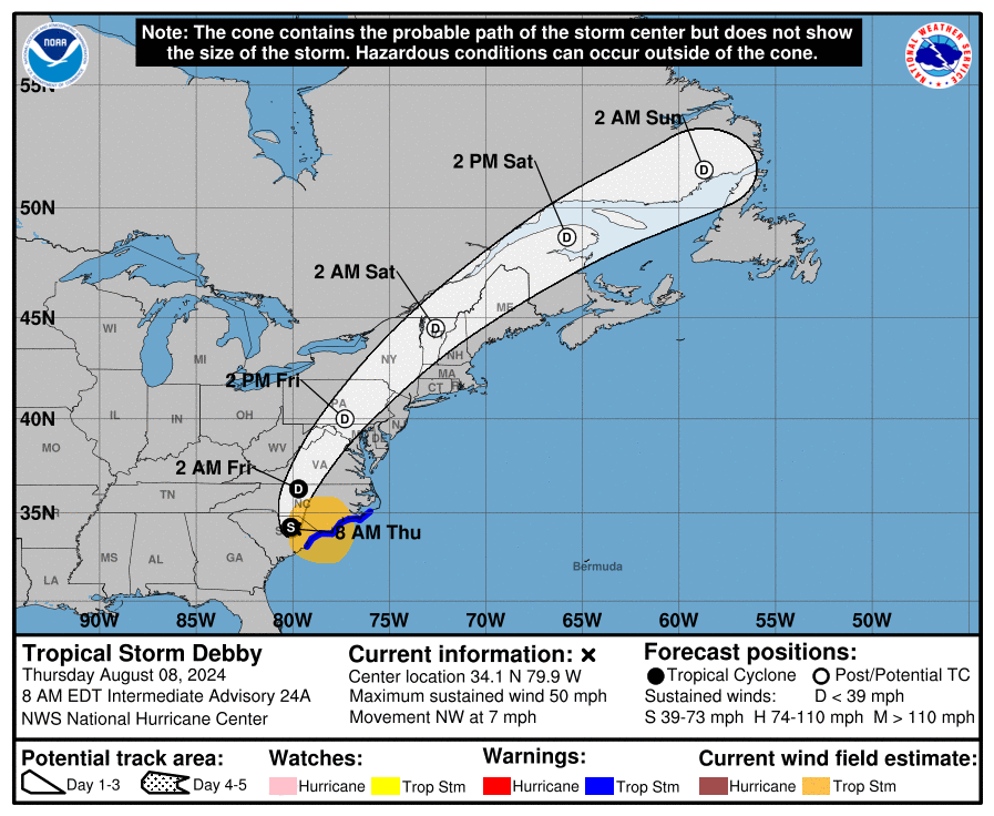
Meanwhile, Tropical Storm Debby, which has already dumped more than a foot of rain on parts of the South and is forecast to bring more, made a second landfall in the U.S. early Thursday when it crossed back into South Carolina.
The storm, which had 50 mph winds, made landfall near Bulls Bay, South Carolina, the National Hurricane Center said in a 2 a.m. ET update.
It was a Category 1 hurricane when it first made landfall near Steinhatchee in Florida’s Big Bend region at around 7 a.m. Monday.
“The big story with Debby is going to continue to be the rainfall,” National Hurricane Center Director Michael Brennan said in a 5 p.m. Wednesday update.
There have been six deaths related to the storm, five of which occurred in Florida, according to reports from officials. Another person died in Georgia. Most of the deaths were from falling trees.
The storm is slow, and it’s not forecast to start leaving North Carolina until tonight or tomorrow. It is expected to continue to weaken as it moves inland.
“We expect this storm to continue its slow, gradual approach, bringing multiple days of heavy rainfall and the potential for widespread and severe flash flooding,” North Carolina Gov. Roy Cooper said Wednesday. Parts of the state could get 15 inches of rain.
While the center of the storm made landfall, its effects are widespread. When it was still out to sea off South Carolina at around 5 p.m., the storm was affecting weather from Florida to the Carolinas and into to the Mid-Atlantic states, Brennan said.
The community of Parrish, Florida, around 20 miles southeast of St. Petersburg, recorded almost 19 inches of rain by early Tuesday, the National Weather Service said. Sarasota got a foot of rain, and officials reported hundreds of rescues in Sarasota County.
An EF-1 tornado associated with an outer rain band of the tropical storm damaged roofs of homes on the Isle of Palms in South Carolina on Tuesday, the weather service said. In all, 29 homes suffered damage from the winds or falling trees, it said.
Another EF-1 tornado associated with the storm hit Edisto Island on Monday with 90 mph winds, according to the agency. It tore down trees and ripped off part of the roof of a home.
Contributing to this article was NBCNews.com