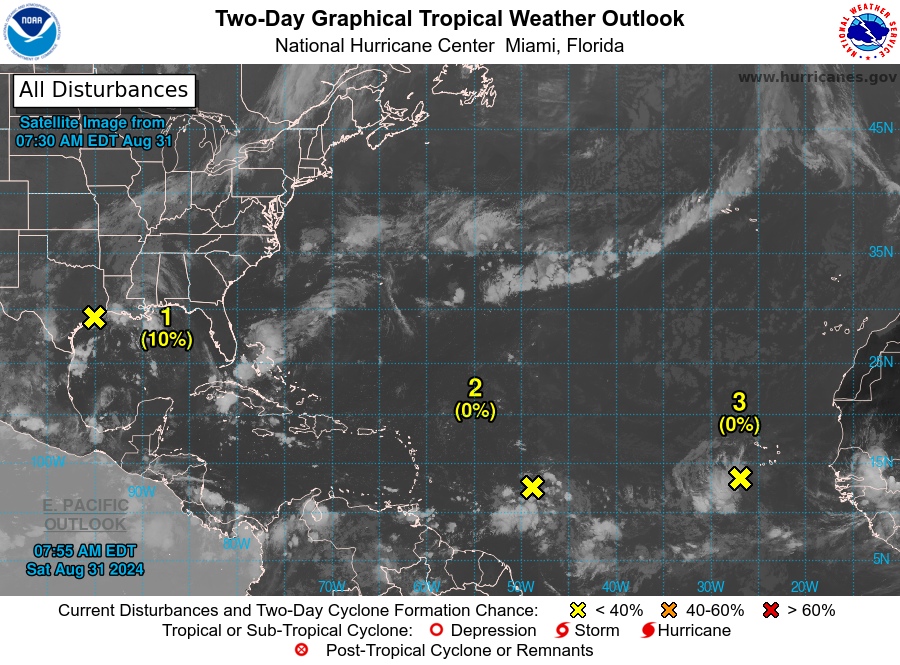
SAN JUAN — Showers and thunderstorms associated with a tropical wave several hundred miles east of the Lesser Antilles remain disorganized.
Gradual development of this system is possible during the next few days, and a tropical depression could form some time next week.
While it moves westward, it is likely to reach the Lesser Antilles on Monday and
continue across the Caribbean Sea through the middle to latter part of the week.
An excessive heat warning remains in effect for St. Croix from 10:00 a.m. to 5:00 p.m. today and tomorrow.
* Formation chance through 48 hours…low…near 0 percent.
* Formation chance through 7 days…medium…50 percent.

Eastern Tropical Atlantic
Another tropical wave just the west of the Cabo Verde Islands is producing disorganized shower and thunderstorm activity. Some slow development of this system is possible through late next week while it moves slowly to the west-northwest over the eastern and central
tropical Atlantic.
* Formation chance through 48 hours…low…near 0 percent.
* Formation chance through 7 days…low…20 percent.
Northwestern Gulf of Mexico
A surface trough of low pressure over the northwestern Gulf of Mexico is producing a large area of disorganized showers and thunderstorms along and just offshore the coasts of Texas and
Louisiana.
Surface observations continue to show no signs of a closed circulation.
This system is expected to meander near the coast through much of next week, and some slow development is possible if it remains offshore.
Regardless of development, heavy rains could cause some flash flooding across portions of coastal
Louisiana and the upper Texas coast during the next few days.
* Formation chance through 48 hours…low…10 percent.
* Formation chance through 7 days…low…20 percent.
