SAN JUAN — The bad news about yesterday’s start to the Atlantic Hurricane Season is that more favorable conditions for cyclonic development are forecast between mid to late June.
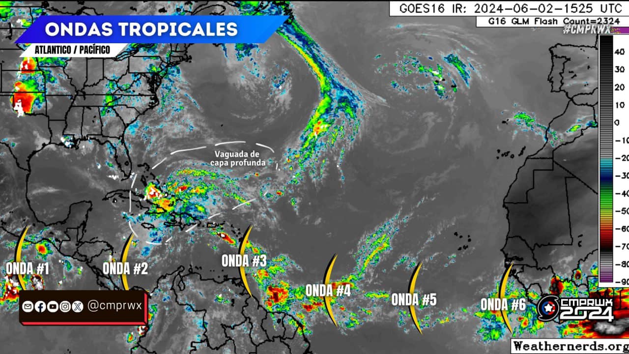
Wet and unstable conditions are expected early next week as a tropical wave approaches Puerto Rico from the southeast and a wide surface wave develops west of the region.
This will increase the risk of torrential rainfall in most of the forecast areas, causing flooding in urban areas, roads and small streams, as well as isolated flash flooding during the coming week. Residents and visitors are advised to avoid activities near small creeks and waterfalls due to the risk of sudden overgrowth from area rivers. Thunderstorms today could produce frequent lightning.

A weak mass of Saharan dust lingers over the area, causing a combination of fog and increased humidity. This weather pattern will contribute to warm to very hot temperatures.
![]() The models project a decrease in wind shear in the Caribbean Sea and the Gulf of Mexico, which in combination with the high ocean temperatures and the arrival of the Madden-Julian Oscillation (MJO) in its active phase will be favoring the formation of some tropical system.
The models project a decrease in wind shear in the Caribbean Sea and the Gulf of Mexico, which in combination with the high ocean temperatures and the arrival of the Madden-Julian Oscillation (MJO) in its active phase will be favoring the formation of some tropical system.
![]() The Climate Prediction Center (CPC/NOAA) has kept under surveillance for several days the East Pacific region south of Mexico and the Caribbean/Gulf of Mexico in front of Central America and the Yucatan Peninsula for the possibility of development of some area of interest.
The Climate Prediction Center (CPC/NOAA) has kept under surveillance for several days the East Pacific region south of Mexico and the Caribbean/Gulf of Mexico in front of Central America and the Yucatan Peninsula for the possibility of development of some area of interest.

UPDATE ON TROPICAL WAVES
A tropical wave is crossing the Lesser Antilles and moving into the Caribbean. At 1200 UTC, the axis was located along 62W, from 17N southward, moving west at 10-15 kt. Scattered moderate
convection is in the northeastern Caribbean and Leeward Islands from 14N to 18N between 60W and 65W. 1200 UTC upper air sounding data from Barbados and Trinidad and Tobago aided in the analysis of the wave this morning.
A western Caribbean tropical wave is along 81W from 20N southward. This wave is nearly stationary. Scattered showers are in the vicinity of the wave axis. 1200 UTC upper air sounding data from Kingston, San Andrés, and Grand Cayman aided in the analysis of the wave this morning.
An Atlantic tropical wave is along 15W from 11N southward, moving west at 10 kt. Scattered moderate convection is from 04N to 09N between 15W and 20W.

Based on new data this morning, an Atlantic tropical wave is now analyzed along 29W from 09N southward. Forward motion is an uncertain 10-15 kt. Scattered showers are in the vicinity of this
tropical wave.
An Atlantic tropical wave is near 45W from 12N southward, moving west at 15-20 kt. Convection is described in the Inter Tropical Convergence Zone section.


