DAY ONE (Today and tonight): Excessive Heat…This level of heat affects mostly individuals sensitive to heat, especially those without effective cooling and/or adequate hydration. Those extremely sensitive to heat face the highest risk. Some health systems and heat-sensitive industries could be affected. These conditions are most likely across all the local islands.
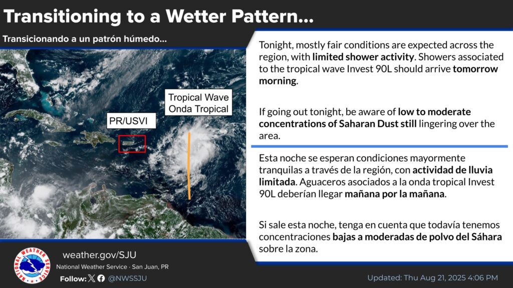
Transitioning to a wetter pattern
Plans for tonight? The weather conditions are looking good for outdoor activities, although be aware of the Saharan Dust still over the region. Although shower activity should be limited tonight, shower activity will increase tomorrow morning due to the approach of tropical wave Invest 90L. Remember the umbrella for tomorrow!
Rip Currents
Life-threatening rip currents are possible in the surf zone, particularly across the northern and eastern exposed beaches of the islands. Isolated stronger rip currents may occur elsewhere, especially near piers, jetties, and channels.
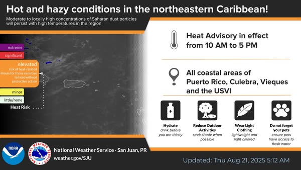
![]() Once again…hot conditions will prevail today under hazy skies due to Saharan dust.
Once again…hot conditions will prevail today under hazy skies due to Saharan dust.
![]()
![]() A Heat Advisory is in effect from 10 AM to 5 PM AST for all the coastal and urban areas of Puerto Rico, Culebra, Vieques and the U.S. Virgin Islands.
A Heat Advisory is in effect from 10 AM to 5 PM AST for all the coastal and urban areas of Puerto Rico, Culebra, Vieques and the U.S. Virgin Islands.
DAYS TWO through SEVENI (Friday to Wednesday):
A strong tropical wave will increase the potential for showers and thunderstorms from late FRiday through Saturday. Across the Virgin Islands, ponding of water in roads is anticipated with isolated urban flooding. For Puerto Rico, urban and small stream flooding are likely along the interior and northwest, with ponding
of water elsewhere. Marine conditions will deteriorate by the end of the week as a northerly swell associated with distant Hurricane Erin. Beaches will be hazardous along the northern and western
coast of Puerto Rico, as well as for St. Thomas and St. John.
Heat Advisory
A Heat Advisory is in effect from 10:00 a.m. this morning to 5:00 p.m. this afternoon, the National Weather Service said.
* WHAT...This level of heat affect mostly individuals sensitive to heat, especially those without effective cooling or adequate hydration. Impacts possible in some health system and in heat-sensitive industries.
* WHERE…All coastal and urban areas of Puerto Rico and the Virgin Islands.
* WHEN…From 10 AM this morning to 5 PM AST this afternoon.
* IMPACTS…Hot temperatures and high humidity may cause heat illnesses.
Recommended actions
Take extra precautions when outside. Wear lightweight and loose-fitting clothing. Try to limit strenuous activities to early morningor evening. Take acti on when you see symptoms of heat exhaustion and heat stroke.
To reduce risk during outdoor work, the Occupational Safety and Health Administration recommends scheduling frequent rest breaks in shaded or air conditioned environments. Anyone overcome by heat
should be moved to a cool and shaded location. Heat stroke is an emergency! Call 9 1 1.
Tropical Weather Outlook
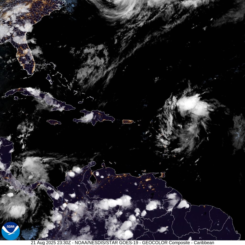
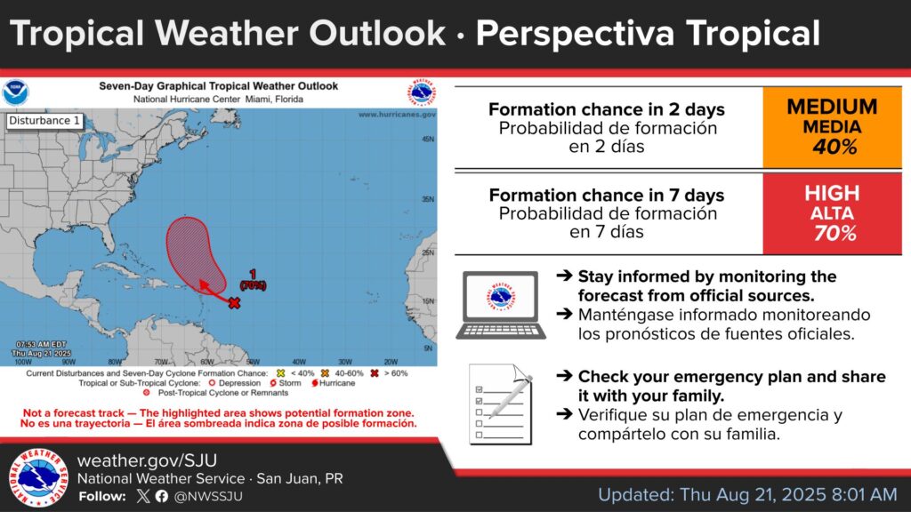
[August 21] 8 AM Tropical Weather Outlook UpdateAn area of showers and thunderstorms associated with a tropical
wave located a few hundred miles east of the Leeward Islands has
changed little over the past several hours. Environmental
conditions appear conducive for further development of this system, and a tropical depression is likely to form this weekend while it moves near or to the north of the northern Leeward Islands.
![]() Formation chance through 48 hours…medium…40%.
Formation chance through 48 hours…medium…40%.
![]() Formation chance through 7 days…high…70%.
Formation chance through 7 days…high…70%.