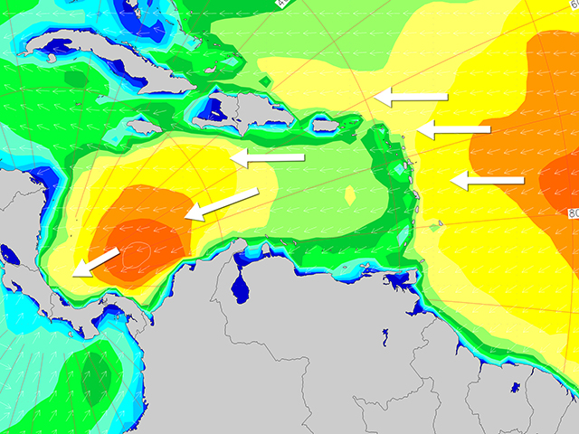
SAN JUAN — While talk of La Nina doesn’t hold the headlines like a strong El Nino event, we are still under La Nina conditions that are forecast to continue through the rest of winter before transitioning to neutral during spring.
One group that is becoming acutely aware of La Nina’s impact on storms and swells are the surfers in the Caribbean. And that includes those that head to the islands during winter to escape the cold water back home.
There has been an obvious lack of significant northerly swells for the Caribbean this winter, replaced with an overabundance of trade winds and trade swell, a surf pattern more associated with summer rather than winter in the islands. The winter has been so slow on the north swell front that outside of a couple of days, the largest surf this season at well exposed north coast breaks has come from trade swell, reaching double overhead and even larger for periods over the past few months. And there is a lot more solid trade swell is on tap for the foreseeable future, too.
While a steady flow of trade swell may be enough to sustain the natives, there are areas of the Caribbean that wait all year for the winter northerly swell season, with limited to minimal swell outside of the winter storm events. These more north and west exposed areas, like Rincon, Puerto Rico for example, won’t be wishing for a La Nina return anytime soon. But when there is yin, there is yang to balance, and that light is found on the other side of the Caribbean, in the Caribbean Sea.
Trade winds across the Caribbean Sea are also elevated this winter, and that means enhanced trade swell for the exposed breaks on the south coast of the islands, mainly in the central and western Caribbean, as well the Caribbean side of Central America and portions of South America, like Colombia. The winter season is also their main surf season, with a nod to a mini-season during the middle of summer. January and February are often the peak months thanks to the trade winds that set up between Atlantic high pressure to the north and lower pressure over Colombia to the south. And based on how good the past few months have been for areas like the Caribbean side of Costa Rica, Panama, Jamaica, and the Dominican Republic, plus how consistent the first half of February is already looking, these surfers are the ones who will be wishing for a rapid return of La Nina in the coming years.
The typical La Nina winter pattern in the Atlantic is characterized by above average pressures over the subtropical Atlantic, stronger easterly winds over the tropics, and below average storm activity over the Western Atlantic. The stronger Atlantic high pressure directs storms on a more northerly track, with less storm activity over the Western Atlantic (the zone where storms primarily generate northerly swells) and into the higher latitudes, tracking across Eastern Canada, Greenland, and Iceland, limiting swell generated for the Caribbean. But the same high pressure ridge that alters the storm track is also responsible for the increase in trade swell and trade winds across the tropics. And that means increased trade winds across the Caribbean, on both the Atlantic and Caribbean Sea coasts.
Looking at the pressure anomaly chart above from the first two months of winter, it’s pretty obvious that we have seen higher pressure over the Atlantic during December and January compared to the past 30years of data. But you might question, how does high pressure over the Azores in the northeast Atlantic impact the surf in the opposite southwest corner of the Caribbean Sea? This very strong high pressure (1036-1050mb) anchors over the Atlantic for extended periods, overtaking much of the North Atlantic and extends far south across the Caribbean. It’s the easterly flow around the southern periphery of the ridge, enhanced by the pressure gradient over the Caribbean Sea between the high and the ‘Colombian Low’, that is responsible for the elevated easterly trade winds and swell. And the stronger the ridge, the stronger the winds, and the stronger the surf.
We are currently in the middle of one of these patterns, with strong high pressure over the central Atlantic that is reinforced during the week and over the weekend, with more reinforcements expected next week. It looks like the current run of solid trade swell for both sides of the Caribbean is likely to continue for at least another week.


