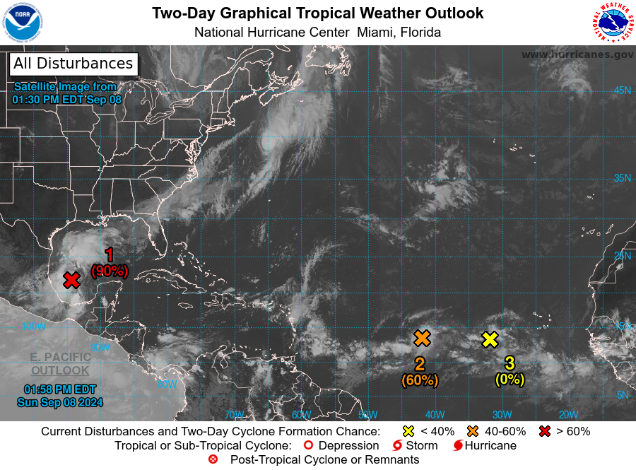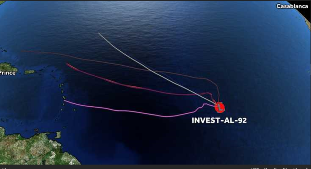
SAN JUAN — The National Hurricane Center is monitoring Invest 92-L in the Central Atlantic.
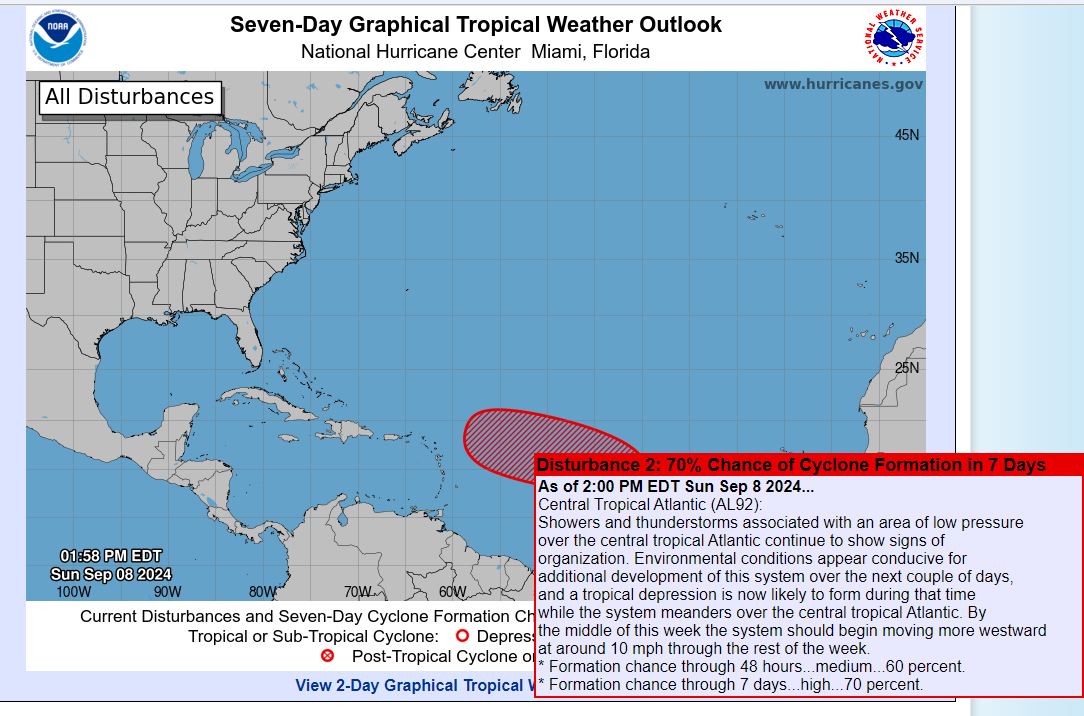
This disturbance has a 60 percent chance of formation over the next seven days as it moves Westward in the Central Atlantic.
Showers and thunderstorms associated with this elongated area of low pressure over the central tropical Atlantic continue to show some signs of organization.
Environmental conditions appear conducive for additional development of this system, and a tropical depression could form while the system meanders over the central tropical Atlantic through tomorrow.
As it begins to form it will move generally westward at around 10 mph through the rest of the week.
A heat advisory is in effect for St. Thomas, St. John, St. Croix and most coastal areas of Puerto Rico from 10:00 a.m. to 5:00 p.m. today.
* Formation chance through 48 hours…medium…60 percent.
* Formation chance through 7 days…high…70 percent.
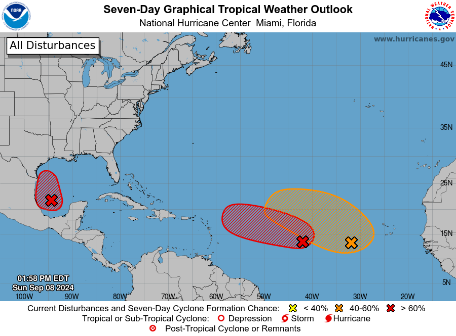
Eastern and Central Tropical Atlantic
Meanwhile, a trough of low pressure located several hundred miles southwest of the Cabo Verde Islands is producing a broad area of disorganized showers and thunderstorms.
This system is expected to move very little during the next couple of days until it potentially interacts with a tropical wave that is forecast to move off the west coast of Africa tomorrow.
Environmental conditions thereafter are expected to be favorable for gradual development of this system, and a tropical depression could form by the middle or latter part of the week while the system begins moving slowly west-northwestward.
* Formation chance through 48 hours…low…near 0 percent.
* Formation chance through 7 days…medium…50 percent.
Western Gulf of Mexico
Showers and thunderstorms have increased this morning in association with a broad area of low pressure located over the southwestern Gulf of Mexico.
This system, named Invest 91-L, is forecast to drift slowly northwestward during the next couple of days, and environmental conditions are expected to become conducive for additional development.
A tropical depression is likely to form during the next couple of days as the system moves generally northwestward and then northward near or along the Gulf coast of Mexico and Texas through the middle of the week.
Interests along the western and northwestern Gulf Coast should closely monitor the progress of this system.
Watches could be required for portions of the western Gulf coast later today or
tonight.
An Air-Force Reserve Hurricane Hunter aircraft is also scheduled to investigate the system later today.
* Formation chance through 48 hours…high…80 percent.
* Formation chance through 7 days…high…90 percent.