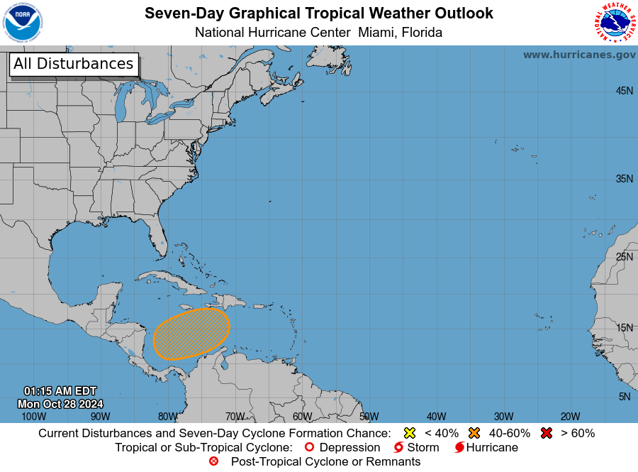
MIAMI — A low pressure system in the southwestern Caribbean Sea is likely to develop in a few days, according to the National Hurricane Center’s latest advisory.
The system currently has a 30 percent chance of formation toward the end of the week and over the weekend while it moves northward or northeastward over the southwestern and south-central Caribbean Sea, NHC forecasters said.
The next named storm of the 2024 Atlantic hurricane season will be called Patty.

A track into Florida or the southeastern U.S. can’t be ruled out at this time, AccuWeather forecasters said, and residents should monitor the tropics and stay prepared.
The hurricane center is also monitoring three tropical waves, one in the eastern Atlantic and two in the Caribbean Sea.
The Atlantic hurricane season ends November 30, although storms can — and have — formed after that date, and even before the official start of hurricane season on June 1.
Here’s the latest advisory from the NHC as of 8 a.m., Sunday, October 27:
Tropical Storm Patty? Will Florida see another hurricane?

AccuWeather forecastersare focusing on the western and central Caribbean Sea, which are expected to spawn the next tropical threat. There is a high chance of a tropical depression or storm forming in these waters in early November.
“I know there will be showers and thunderstorms in this zone next week. The question is the wind shear. If there is low wind shear, which we expect, I think we will be getting a tropical depression or storm to form,” AccuWeather Chief On-Air Meteorologist Bernie Rayno said.
A seasonal large, closed, cyclonic circulation called Central American gyre, is expected to bring downpours across the Caribbean this week that can “result in life-threatening conditions such as flash floods and mudslides regardless of whether there is a named tropical system or not.”
“Tropical storms that form in this area late in October and early in November tend to track into Central America or possibly to the north-northeast toward Cuba, Hispaniola and the Bahamas,” said AccuWeather Senior Meteorologist Alex Sosnowski.
“However, a track into Florida or the southeastern U.S. mainland is not out of the question at this early juncture” and residents in the southeastern U.S., along with those in the Caribbean and Mexico are encouraged to monitor the tropics and remain prepared.
Additionally, AccuWeather meteorologists warn of a low risk of tropical development in the northern Caribbean late next week and into the weekend as “a cluster of showers and thunderstorms may organize.”
What’s out there and how likely are they to strengthen?

According to the NHC’s 8 a.m. advisory, a broad area of low pressure is likely to develop over the southwestern Caribbean Sea in a few days. Some gradual development is possible toward the end of the week and over the weekend when the system begins to drift northward or northeastward over the southwestern and south-central Caribbean Sea.
- Formation chance through 48 hours: low…near 0 percent.
- Formation chance through 7 days…low…30 percent.
NHC forecasters also say there are three tropical waves out there, including two in the Caribbean:
- Eastern Atlantic: An eastern Atlantic tropical wave is along 31W, south of 14N, moving westward at 17 mph. Scattered moderate to isolated strong is observed from 03N to 13N and between 22W and 36W.
- Eastern Caribbean Sea: An eastern Caribbean tropical wave is along 63W, south of 16N, and moving westward at around 17 mph. No significant convection is noted near this trough axis.
- Central Caribbean Sea: A central Caribbean tropical wave is along 77W, south of 18N and moving westward at around 11 mph. Isolated thunderstorms are noted from 14N to 18N between 73W and 79W.


