While the tropical Atlantic is quiet now, that could change in a hurry come August with at least one system already being tracked.
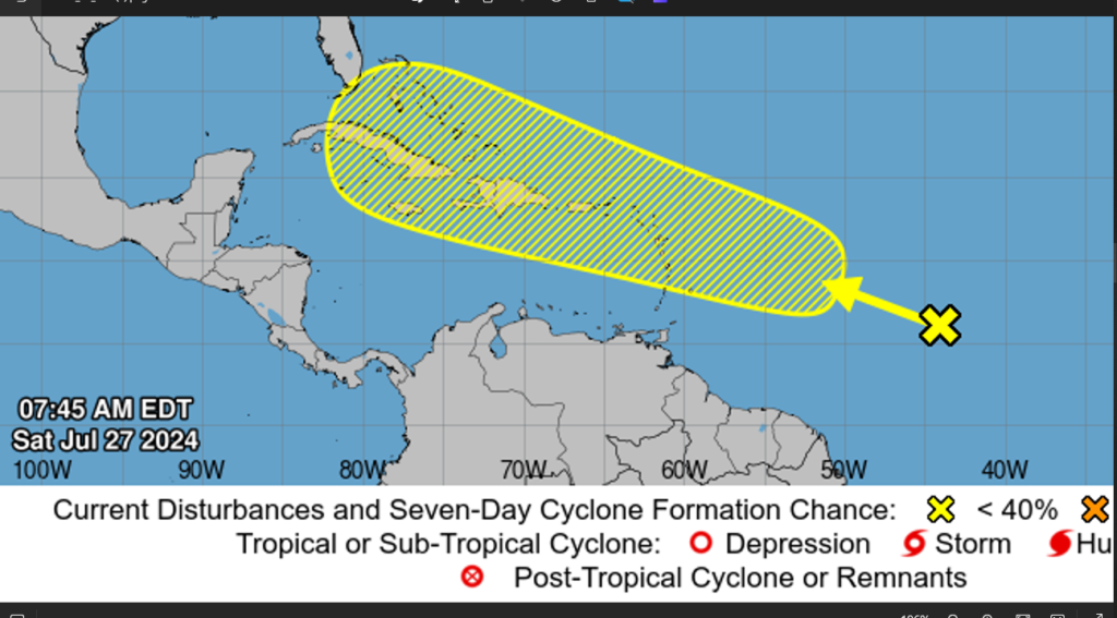
SAN JUAN — An area of disturbed weather over the central tropical Atlantic Ocean is expected to interact with an approaching tropical wave during the next several days.
Development of this system is possible while it approaches the Lesser Antilles during the early to middle part of next week and moves generally west-northwestward near or over the Greater Antilles towards the latter part of next week.

Meanwhile, an area of low pressure recently pushed off the coast of Africa and into the eastern tropical Atlantic. AccuWeather meteorologists say if it survives the swath of dry air and dust in its path, there is the potential for development and the likelihood of a surge of tropical activity in August.
Ripples of low pressure in the atmosphere continuously move from the Indian Ocean, across Africa and into the tropical Atlantic and Pacific basins throughout late spring, summer and early autumn. The vast majority of these tropical waves, as they are called, do not develop. However, once in a while, they gather enough moisture and begin to spin and intensify.

“We are approaching the point of the season [August] where we tend to see more of these systems take hold and organize into tropical depressions, storms, and even hurricanes under the right conditions,” AccuWeather Lead Hurricane Expert Alex DaSilva said.
As August moves in, dry air, dust and disruptive breezes, called wind shear, tend to diminish, while at the same time, the oceans are approaching maximum warmth.
“Dry air, dust and wind shear will be factors against short- to medium-range tropical development of a robust tropical wave that pushed westward and just off the coast of Africa on Thursday morning,” AccuWeather Chief On-Air Meteorologist Bernie Rayno said.

That feature will push westward across the tropical Atlantic through this weekend and into the start of next week.
“If that system is able to survive the hostile conditions as it continues westward, it may encounter more favorable conditions for tropical development near the Caribbean or the Gulf of Mexico around the start of August,” Rayno added.
Since Beryl churned through the area several weeks ago, the ocean water has had plenty of time to recover its unusual warmth and throughout much of the system’s path, that warm water will be favorable for development.
Very warm water, low wind shear and moisture helped Beryl set records for Atlantic early-season development, including the earliest Category 5 hurricane. A Category 5 hurricane is the highest level on the Saffir-Simpson hurricane wind scale, with winds of 157 mph or greater. Beryl’s peak winds reached 165 mph, while over the eastern Caribbean Sea.
Current steering breezes would guide the system near the northern islands of the Caribbean from the Leewards to some of the Greater Antilles in early August.
A close encounter with a formidable tropical system could lead to dangers from flooding rain, storm surge and high winds.
At the very least, this system in a weaker form, as a tropical wave, would bring an uptick in drenching showers and gusty thunderstorms.
Since the winter, AccuWeather’s team of forecasters, led by Lead Hurricane Expert Alex DaSilva, Chief Meteorologist Jonathan Porter and Lead Long-Range Meteorologist Paul Pastelok, have been warning of a super-charged Atlantic hurricane season for 2024.
In the spring, AccuWeather meteorologists also raised the likelihood of multiple storms with the potential to intensify rapidly, which would be an added danger as the systems approach land. Months later, Beryl made AccuWeather’s concern a reality as it blasted across the Windward Islands in the southeastern Caribbean.
* Formation chance through 48 hours…low…near 0 percent.
* Formation chance through 7 days…low…30 percent.


