

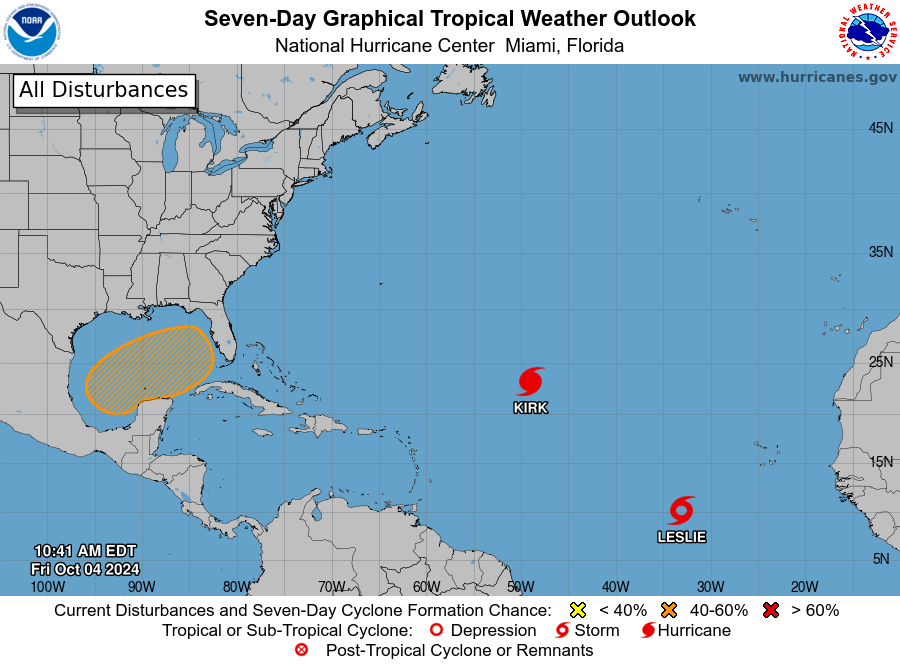
MIAMI — The National Hurricane Center is tracking three tropical disturbances, including two that could affect Florida over the weekend or early next week.
Hurricane Kirk is a Category 4 hurricane with 140-mph winds. Large swells from Kirk could bring life-threatening surf and rip currents to the East Coast of the U.S. by Sunday.
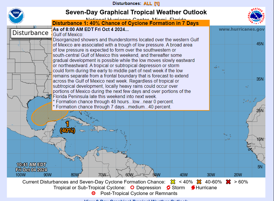
The other system that could affect Florida is the disturbance forecasters have been watching all week: a trough of low pressure in the Caribbean Sea that has now moved into the Gulf of Mexico.
A tropical or subtropical depression or storm could form during the early to middle part of next week, depending on environmental conditions, according to the latest advisory from the National Hurricane Center.
“Regardless of tropical or subtropical development, locally heavy rains could occur over portions of Mexico during the next few days and over portions of the Florida Peninsula late this weekend into next week,” the Hurricane Center said.
Also in the Atlantic basin — which consists of the northern Atlantic Ocean, Caribbean Sea and Gulf of Mexico — is Tropical Storm Leslie, which is not expected to affect Florida or the U.S.
The next named storms in the Atlantic hurricane season will be Milton and Nadine.
“While the exact track and intensity of the feature unfolding in the gulf have yet to be determined, Florida will bear the brunt this time around,” said AccuWeather Chief On-Air Meteorologist Bernie Rayno.
“While the activity is still not organized, nearly every indicator suggests that a feature will form in the southwestern Gulf from late this weekend to the middle of next week and track northeastward and across the Florida Peninsula,” AccuWeather said.
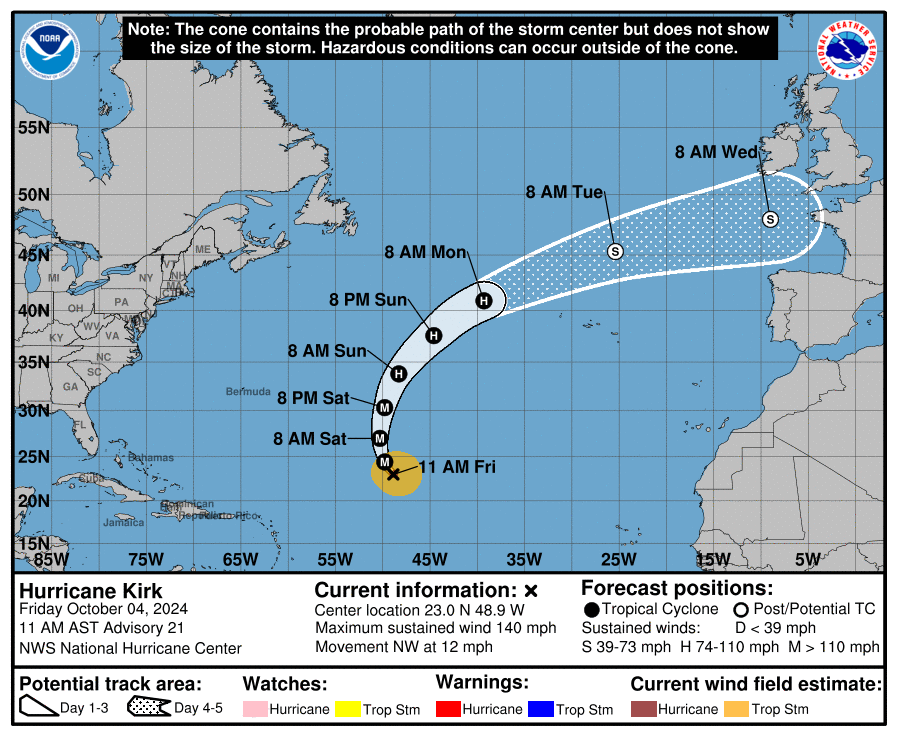
Hurricane Kirk: What you should know
- Location: 975 miles east-northeast of the Northern Leeward Islands; 1,655 miles west-southwest of the Azores
- Maximum sustained winds: 140 mph
- Movement: northwest at 12 mph
At 11 a.m., the center of Hurricane Kirk was located near latitude 23.0 North, longitude 48.9 West.
Kirk is moving toward the northwest near 12 mph, and this general motion is expected to continue today. A turn toward the north and north-northeast at a faster forward speed is anticipated over the weekend.
Maximum sustained winds are near 140 mph, with higher gusts. Kirk is a Category 4 hurricane on the Saffir-Simpson Hurricane Wind Scale. Small intensity fluctuations are possible today and tonight. Weakening is forecast to begin on Saturday and continue through early next week.
Hurricane-force winds extend outward up to 35 miles from the center and tropical-storm-force winds extend outward up to 195 miles.
Impacts: Swells generated by Kirk are spreading westward and are expected to reach the Leeward Islands later today, Bermuda and the Greater Antilles on Saturday, the east coast of the United States, Atlantic Canada, and the Bahamas on Sunday, and the Azores on Monday.
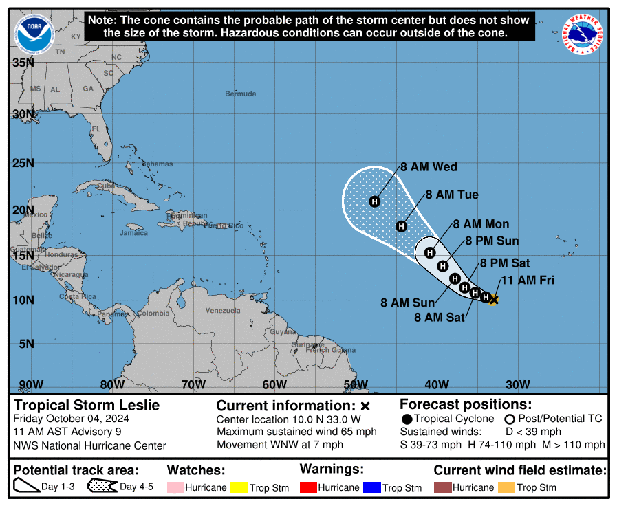
Tropical Storm Leslie: What you should know
- Location: 670 miles west-southwest of Cabo Verde Islands
- Maximum sustained winds: 65 mph
- Movement: west-northwest at 7 mph
At 11 a.m. EDT, the center of Tropical Storm Leslie was located near latitude 10.0 North, longitude 33.0 West.
Leslie is moving toward the west-northwest near 7 mph. A turn toward the west-northwest is expected later today, followed by a turn toward the northwest and an increase in forward speed early Sunday into Monday.
Maximum sustained winds have increased to near 65 mph, with higher gusts. Additional strengthening is forecast, and Leslie is expected to become a hurricane tonight or Saturday.
Tropical-storm-force winds extend outward up to 60 miles from the center.
Impacts: No impacts to land are expected.
What else is out there and how likely is it to strengthen?
Northwestern Caribbean Sea and Gulf of Mexico: Disorganized showers and thunderstorms located over the western Gulf of Mexico are associated with a trough of low pressure.
A broad area of low pressure is expected to form over the southwestern or south-central Gulf of Mexico this weekend, and thereafter some gradual development is possible while the low moves slowly eastward or northeastward.
A tropical or subtropical depression or storm could form could form during the early to middle part of next week if the low remains separate from a frontal boundary that is forecast to extend across the Gulf of Mexico next week.
Impacts: Regardless of tropical or subtropical development, locally heavy rains could occur over portions of Mexico during the next few days and over portions of the Florida Peninsula late this weekend into next week.
- Formation chance through 48 hours: low, near 0 percent.
- Formation chance through 7 days: medium, 40 percent.
What do the colored areas on the NOAA map mean?
The hatched areas on a tropical outlook map indicate “areas where a tropical cyclone — which could be a tropical depression, tropical storm or hurricane — could develop,” said National Hurricane Center Deputy Director Jamie Rhome.
The colors make it visibly clear how likely a system could develop with yellow being low, orange medium and red high.
The National Hurricane Center generally doesn’t issue tropical advisories until there is a named storm, but there is an exception.
“If a system is near land and there is potential for development, the National Hurricane Center won’t wait before it issues advisories, even if the system hasn’t become an actual storm. This gives residents time to prepare,” Rhome said.