
MIAMI — A potential tropical disturbance in the eastern Atlantic Ocean is embarking on a long journey west, though it appears for now it’ll keep from developing into a tropical depression today, according to the National Hurricane Center.
The disturbance, currently designated Invest 94L by the NHC, is located a few hundred miles west of the Cabo Verde Islands. It brought tropical storm-force winds and heavy rains to the archipelago Friday night.
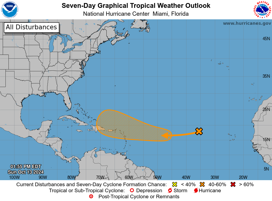
The NHC said on Sunday that shower and thunderstorm activity associated with the area of low pressure a few hundred miles west of the Cabo Verde Islands have increased over the past several hours. However, the system is now moving into an area that is less favorable for father development.
“Therefore, during the next few days the chance of tropical cyclone formation appears to be decreasing,” the NHC said.

The system is expected to contin to move to the west or west-southwest over the tropical Atlantic, and it may encounter conditions more conducive for development over the western Tropical atlantic by the middle of this upcoming week.
Right now, the NHC is giving the system a low chance of developing over the next week.
Eastern Tropical Atlantic
Showers and thunderstorms have diminished again in associated with an area of low pressure located a few hundred miles west of the Cabo Verde Islands, the National Hurricane Center said today.
While the system is currently embedded in an environment that is not favorable for development over the next couple of days, the system is forecast to move generally westward to west-southwestward across the tropical Atlantic.
In this area, the environmental conditions could become more favorable for gradual development in the central Tropical Atlantic by the mid to latter part of this week, according to the NHC.

* Formation chance through 48 hours…low…10 percent.
* Formation chance through 7 days…medium…40 percent.
What is an invest?
Forecasters will keep a close eye on the storm as it begins to approach the eastern fringes of the Caribbean.
“(It will) proceed on a westerly path that could take it near the northeastern Caribbean islands in about a week,” FOX Weather Hurricane Specialist Bryan Norcross said. “The disturbance could arrive as anything from a developing tropical disturbance, to Tropical Storm Nadine, to a messy surge of tropical moisture.”