MIAMI — Tropical Storm Sam formed far in the Atlantic Ocean today and is expected to strengthen into a hurricane tomorrow and a major hurricane — Category 3 or higher — by early next week.
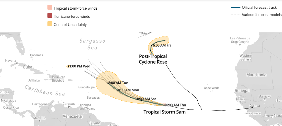
The forecast track shows Sam tracking close to the eastern edge of the Caribbean by Tuesday.
From there, it’s unclear where the storm will go. Here’s the latest forecast path, including the so-called “spaghetti models,” which show the paths predicted by the various forecast models:
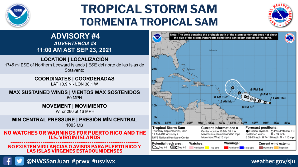
The NHC reports Tropical Storm Sam sports maximum sustained winds of 50 miles per hour as it trundles about 1,750 miles east-southeast of the northern Leeward Islands. It is moving west at 18 mph.
Forecasters expected Sam to keep its current path before making a more northwest turn starting tomorrow and into the weekend.
Sam became a tropical storm at 11:09 a.m. today and is expected to become a hurricane tomorrow, possibly becoming a major hurricane by early next week.
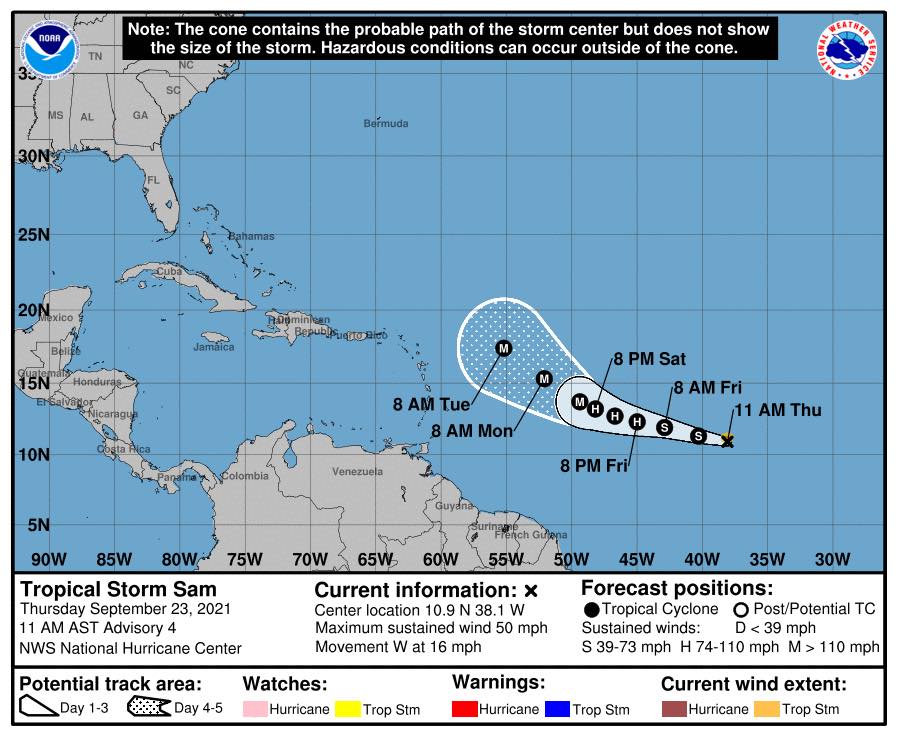
Sam is now the 18th named system of the season, topping the average of 14 for an entire year. The six named hurricanes are below the average of seven, while the three major hurricanes are on average for an entire season.
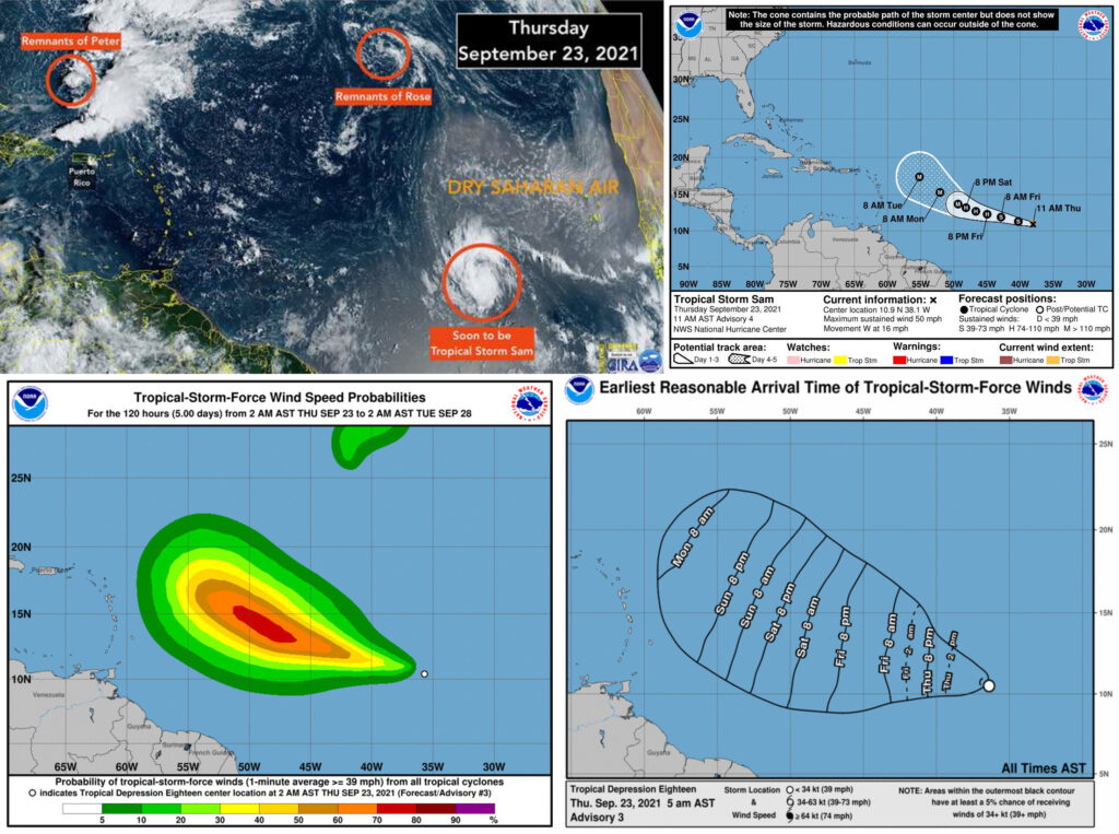
Satellite images indicate that the tropical depression has been more or less steady in strength overnight. Curved bands remain most organized to the north and west of the center with some dry air wrapping into the eastern half of the circulation. The initial intensity is held at 30 kt as a compromise between the earlier ASCAT data that showed peak winds around 25 kt and 2.5/35 kt Dvorak classifications from TAFB and SAB.
The initial motion is estimated to be 280/13 kt. The cyclone is located on the south side of a mid-level ridge, and that should continue to steer the system westward but at a slightly slower pace during the next couple of days. After that time, the ridge is expected to weaken and shift eastward. In response, the depression is forecast to turn west-northwestward to northwestward and slow down some more. The new NHC track forecast is largely an update of the previous one and lies near the middle of the guidance envelope, near the consensus aids.
This forecast is also between the GFS model on the north side of the guidance and the ECMWF on the south side. Environmental conditions all seem to be favorable for the storm to gain strength during the next several days. The cyclone is expected to traverse warm 28 degree C waters and move in an environment of low wind shear (less than 10 kt) and fairly high moisture. Nearly all of the models respond by showing steady strengthening during the next several days, and so does the official forecast.
This prediction lies near the IVCN and HCCA aids, which are usually the most skillful. The official forecast shows the system becoming a tropical storm later today, a hurricane in a couple of days, and a major hurricane by the end of the forecast period. In fact, some of the models suggest that the storm could get even stronger than currently forecast.
FORECAST POSITIONS AND MAX WINDS
INIT 23/0900Z 10.5N 36.4W 30 KT 35 MPH
12H 23/1800Z 10.8N 38.4W 35 KT 40 MPH
24H 24/0600Z 11.3N 40.9W 40 KT 45 MPH
36H 24/1800Z 11.9N 43.3W 50 KT 60 MPH
48H 25/0600Z 12.5N 45.2W 60 KT 70 MPH
60H 25/1800Z 13.0N 46.9W 70 KT 80 MPH
72H 26/0600Z 13.7N 48.3W 80 KT 90 MPH
96H 27/0600Z 15.0N 50.8W 90 KT 105 MPH
120H 28/0600Z 16.9N 53.9W 100 KT 115 MPH