
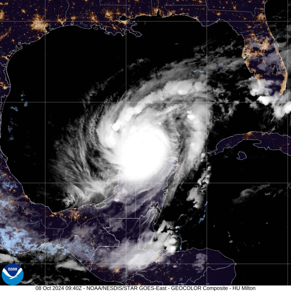
MIAMI — Hurricane Milton continued tracking eastward as a powerful Category 4 storm early this morning, with forecasts showing it on a path to hit Florida’s Gulf Coast mid-week. The storm was moving at 12 miles per hour over warm waters in the Gulf of Mexico and had maximum sustained winds of 155 mph, the National Hurricane Center said.
“This is an extremely life-threatening situation & residents should follow advice given by local officials & evacuate immediately if told to do so,” the hurricane center warned.
Forecasters predict Milton will make landfall as a major hurricane around the Tampa Bay area on Wednesday, though they said they expect it to weaken somewhat from its peak before striking land.
“While fluctuations in intensity are expected, Milton is forecast to remain an extremely dangerous hurricane through landfall in Florida,” the hurricane center said.
It will drench a large part of a state still reeling from Hurricane Helene. But predictions oscillated Monday on the timing of Milton’s landfall and the expected strength when it arrives, as the hurricane has changed quickly in a matter of hours.
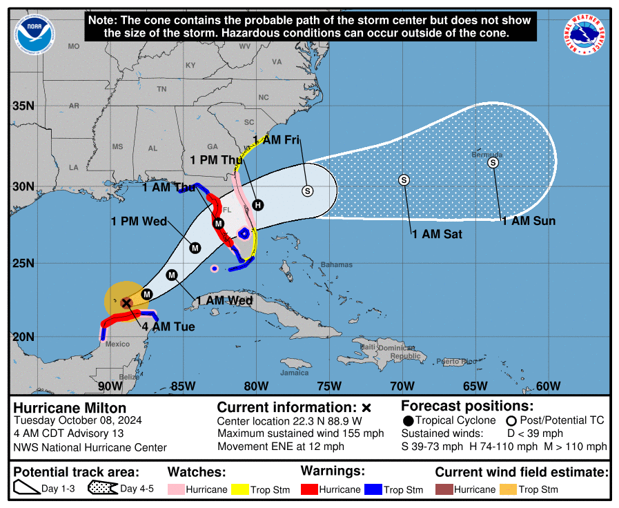
Path of Hurricane Milton
Maps from the National Hurricane Center show Milton bearing down on Florida’s west coast as a major hurricane.
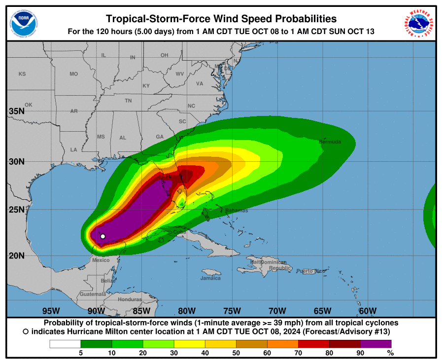
A hurricane warning was in effect for the west coast of Florida from Bonita Beach northward to the mouth of the Suwannee River, including Tampa Bay.
“Milton’s remarkable rapid intensification is continuing,” the hurricane center said.
The storm is expected to travel north of the Yucatan peninsula through Tuesday, with heavy rainfall expected as Milton makes its way northeast toward Florida. The Mexican government issued a hurricane warning from Celestun to Rio Lagartos, a hurricane watch from Celestun to Cabo Catoche, and a tropical storm warning from east of Cabo Catoche to Cancun.
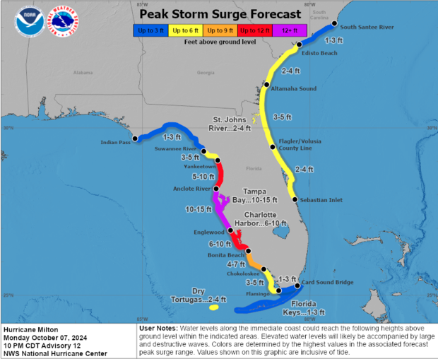
A storm surge warning has been issued for the west coast of Florida from Flamingo northward to the Suwannee River, including Charlotte Harbor and Tampa Bay.
The hurricane center warned Monday that storm surge in the Tampa Bay area could reach 10 to 15 feet above ground level.
The National Hurricane Center warned of heavy rainfall of up to 15 inches in portions of the Florida Peninsula through Thursday, which could generate “considerable flash, urban and areal flooding, along with moderate to major river flooding.”
Florida officials prepare for more impact
Florida Gov. Ron DeSantis on Monday urged those in the hurricane’s path to heed the warnings of local officials.
“Evacuations are underway, and we have suspended tolls and opened roadway shoulders to make it easier for Floridians to get to safety,” DeSantis said on social media. “The State of Florida continues to fulfill requests from communities in the potential path of Hurricane Milton as we prepare for landfall. Hundreds of first responders will be embedded in potential impact sites along Florida’s west coast to begin search and rescue operations as soon as the storm passes.”
The Federal Emergency Management Agency, meanwhile, coordinated with the governor and briefed President Biden Sunday on how it has staged lifesaving resources ahead of the storm.
“I highly encourage you to evacuate” if you’re in an evacuation zone, said Kevin Guthrie, executive director of the Florida Division of Emergency Management. “We are preparing … for the largest evacuation that we have seen, most likely since 2017, Hurricane Irma.“
By CBS News

