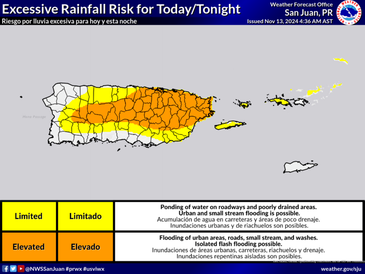
SAN JUAN — A less active day in terms of rain is expected, but the combination of the light wind flow, daytime heating and local sea breeze variations will result in afternoon showers and isolated thunderstorms.
The activity should be focused mainly over the central interior and northern half of Puerto Rico.
Already saturated soils from previous rains increase the risk of flooding, landslides and quick river risings.
Deteriorated marine and coastal conditions will continue through this afternoon due to pulses of a northerly swell.

Areas at Risk
- Flooding threat: From limited to elevated across Puerto Rico and the U.S. Virgin Islands. (See attached image).
- Mudslide threat: Saturated soils due to rainfall over the recent days.
Dangerous marine and coastal conditions until this afternoon:
- High risk of rip currents: Across the north-facing beaches of Puerto Rico, from Rincón to Fajardo, Culebra, Vieques, St. Thomas, and St. John, in effect until this afternoon.
- High Surf Advisory: Across the north-facing beaches of Puerto Rico, from Aguadilla to Fajardo, Culebra, St. Thomas, and St. John in the U.S. Virgin Islands, in effect until this afternoon. Large breaking waves up to 8-10 feet producing dangerous swimming conditions and minor beach erosion.
- Small Craft Advisory: For the offshore and coastal Atlantic waters, in effect until this afternoon.

The risk of rip currents is forecast to decrease to moderate by Thursday. However, another swell is anticipated for the end of the week, which may again deteriorate marine and coastal conditions.
For updates on excessive rainfall, lightning, and other hazard risks, along with a detailed map of the areas at risk, refer to the Experimental Graphical Hazard Weather Outlook: https://www.weather.gov/erh/ghwo?wfo=sju.


