Friday August 22, 2025
![]()
![]()
![]()
![]()
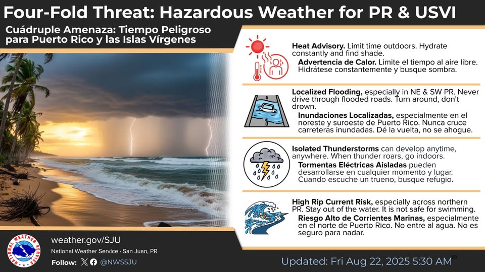
![]() Four-Fold Threat For the U.S. Virgin Islands and Puerto Rico
Four-Fold Threat For the U.S. Virgin Islands and Puerto Rico
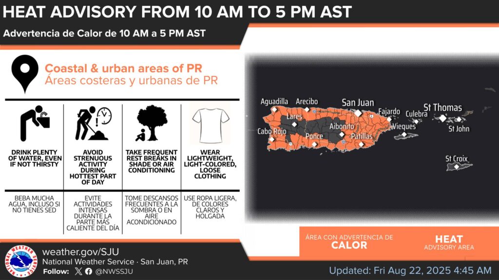
![]() Heat: Drink water, stay hydrated and find shade
Heat: Drink water, stay hydrated and find shade
![]()
![]() Floods / Never cross flooded roads
Floods / Never cross flooded roads
![]()
![]() Thunderstorms: When you hear thunder, seek shelter/Stay indoors
Thunderstorms: When you hear thunder, seek shelter/Stay indoors
![]()
![]() Rip Currents:: Stay out of the water
Rip Currents:: Stay out of the water
Remember: Safety first! It’s job one! Today and every day … your life might depend on it.
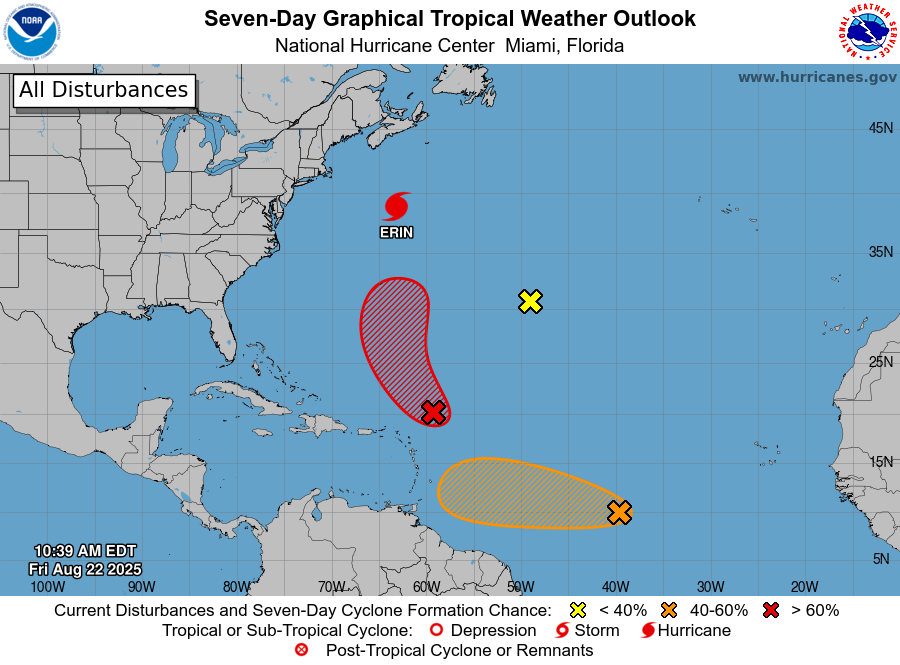
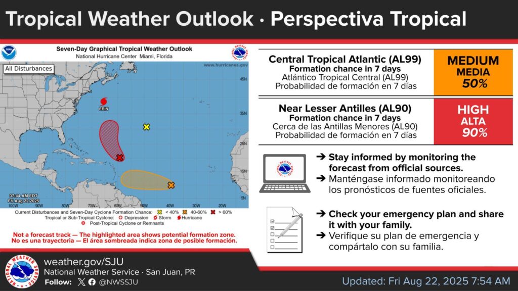
[Aug 22nd] 8 AM Tropical Weather Outlook ![]()
The NHC is monitoring 3 disturbances with a cyclonic formation chance over the Atlantic: two of those are the tropical waves AL90 & AL99.
AL90 ![]() is located near the Lesser Antilles and has a high formation chance in 48 hours (80%) and a high formation chance in 7 days (90%).
is located near the Lesser Antilles and has a high formation chance in 48 hours (80%) and a high formation chance in 7 days (90%).
AL99 ![]() is located in the Central Tropical Atlantic and has a medium formation chance in 48 hours (40%) and a medium formation chance in 7 days (50%). For more information, visit hurricanes.gov.
is located in the Central Tropical Atlantic and has a medium formation chance in 48 hours (40%) and a medium formation chance in 7 days (50%). For more information, visit hurricanes.gov.
[August 22nd] Tonight
-Due to the approach of tropical wave Invest AL90, shower activity will increase, affecting mainly the U.S. Virgin Islands and eastern portions of Puerto Rico. Exercise caution when driving across these areas.
-Beach conditions along northern and eastern Puerto Rico, including Culebra, and St. Thomas and St. John in the U.S. Virgin Islands are deteriorating due to a northerly swell from distant Hurricane Erin. Swimmers are urged to avoid these beaches.

[August 22nd 8:30 PM AST]
Marine and coastal conditions are deteriorating due to a long-period swell from distant Hurricane Erin.
This is expected spread across the islands and persist ALL THE WEEKEND.
Heed the advice of the flag warning system. Stay ashore & avoid unnecessary trips to sea.
St. Thomas St. John adjacent Islands St. Croix nearshore Atlantic and adjacent Caribbean coastal waters as of 4:40 a.m. Atlantic Standard Time (AST) Friday August 22, 2025.
This Hazardous Weather Outlook is for portions of the U.S. Virgin Islands.
DAY ONE (Today and tonight)
* Lightning…Isolated thunderstorms, associated to a passing tropical wave. Stay alert and be prepared to take shelter if storms develop.
* Excessive Rainfall…Ponding of water in roads and poorly drained areas. There is a low chance of localized urban and small streams flooding.
* Excessive Heat…This level of heat affects primarily those individuals extremely sensitive to heat, especially when outdoors without effective cooling and/or adequate hydration.
* Marine Conditions…Small craft should exercise caution, particularly across the Atlantic waters.
* Rip Currents…Life-threatening rip currents are possible in the surf zone, particularly across St Thomas and St John. Isolated stronger rip currents may occur elsewhere, especially near piers, jetties, and channels.

DAYS TWO THROUGH SEVEN (Saturday through Thursday)
* Excessive rainfall from a passing tropical wave (99L) is expected to continue on Saturday. Excessive heat risks are expected to persist throughout the forecast period.
* Swells from Hurricane Erin will maintain a moderate rip current risk through Saturday, increasing to high on Sunday, with hazardous seas developing Saturday night through Tuesday.
* Breezy to locally windy conditions will exacerbate marine hazards, particularly Sunday into Monday.
* A Saharan Air Layer is expected to bring hazy skies and reduced air quality from Sunday through Tuesday.