SAN JUAN — A fifth tropical wave has peeled off the coast of Africa near the Cape Verde Islands — one day before the official start of the Atlantic hurricane season.
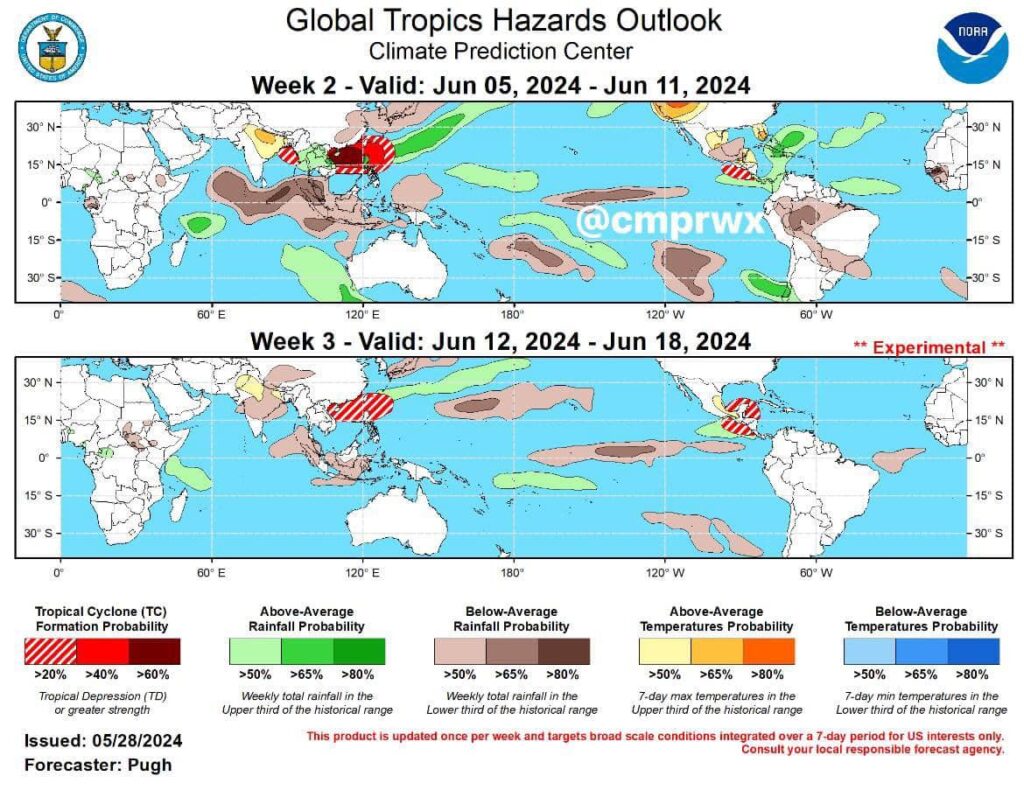
There is potential for above-normal precipitation during the first weeks of June for the Bahamas region, Cuba, Hispaniola, and portions of Central America.
The possibility of cyclonic development is monitored (long term) in the Western Caribbean and the Northeast Pacific basin and off the coast of Central America and the Yucatan Peninsula during mid-June.

A far eastern Atlantic tropical wave is near 24W/25W from 11N southward, and moving westward at 15 to 20 kt. Widely scattered moderate convection is seen from 03N to 08N between 09W and 37W.
A central Atlantic tropical wave is near 45W from 11N southward and moving westward at 15 to 20 kt. Widely scattered moderate convection is noted from 05N to 11N between 39W and 47W.
A Caribbean tropical wave is near 69W/70W from near the southeast Dominican Republic southward into northwestern Venezuela and moving westward at around 15 kt. Widely scattered showers are present south of 17N between 64W and 73W.

A pair of surface troughs is analyzed over the SW N Atlantic, one from 31N76W to 28.5N79.5W, and the other from 31N72W to 24N76W. Scattered showers and thunderstorms are noted from 27N to 29N between 63W and 70W. Convergent southerly winds are generating similar convection S of 25N including over the central and southeastern Bahamas, eastern Cuba, and Hispaniola. Refer to the Monsoon Trough/Inter Tropical Convergence Zone and Tropical Waves sections for additional convection in the Atlantic Ocean.
Moderate to locally fresh northeastern winds are west of the western trough off northeastern Florida along with seas of 3 to 5 feet. Mainly gentle to locally moderate winds prevail elsewhere across the waters north of 20N and W of 25W. A cold front reaches from 31N25W to 26N41W, continuing as a stationary front to 29N51W. Seas are 2 to 4 feet elsewhere north of 20N and west of 55W, with 3 to 5 feet seas north of 20N and east of 55W, except 5 to 7 feet north of 29N between 30W and 40W in northerly swell behind the front. Moderate to locally fresh winds are S of 20N along with 4 to 6 feet seas, as well as offshore Africa to 23W from the Cabo Verde Islands northward.
For the forecast, the pair of troughs W of 70W will merge and shift east through the upcoming weekend, possibly as an energized cold front. This feature will reach from 31N63W to the central
Bahamas early tomorrow from 29N55W to the SE Bahamas by Sunday with the tail-end of the boundary stalling. High pressure building in behind the front will tighten the pressure gradient across the region, bringing moderate to fresh winds and across waters north of 24N, along with building seas. Conditions will slightly improve across the waters by early next week.

CARIBBEAN SEA
Aided by divergent winds aloft, convergent trade winds are producing scattered showers and isolated thunderstorms offshore eastern Honduras and northern Nicaragua. Similar convection
between Jamaica and western Cuba, and near Haiti has temporarily diminished. Refer to the Monsoon Trough/Inter Tropical Convergence Zone and Tropical Waves sections for additional convection in the Atlantic Ocean.
Moderate to fresh easterly winds and seas at 5 to 7 feet are found at the south-central and southeastern basin, including waters near the ABC Islands. Gentle to moderate with locally fresh E winds and 4 to 6 feet seas dominate the rest of the Caribbean Sea, except moderate to
fresh winds near the Gulf of Honduras, and 1 to 3 feet seas in the northwestern Caribbean N of 18N.
For the forecast, a moderate pressure gradient between high pressure north of the area and low pressure near Colombia will support fresh to locally strong trade winds over the south-central
Caribbean today. The pressure gradient will increase tonight into tomorrow behind a tropical wave that has exited the Caribbean. This will lead to fresh to strong trade winds across the central basin
Sat through early Monday, along with seas to around 8 feet. Winds will slightly diminish by early next week. Smoke from agricultural fires over Central America is causing reduced visibility over
portions of the Gulf of Honduras..


