
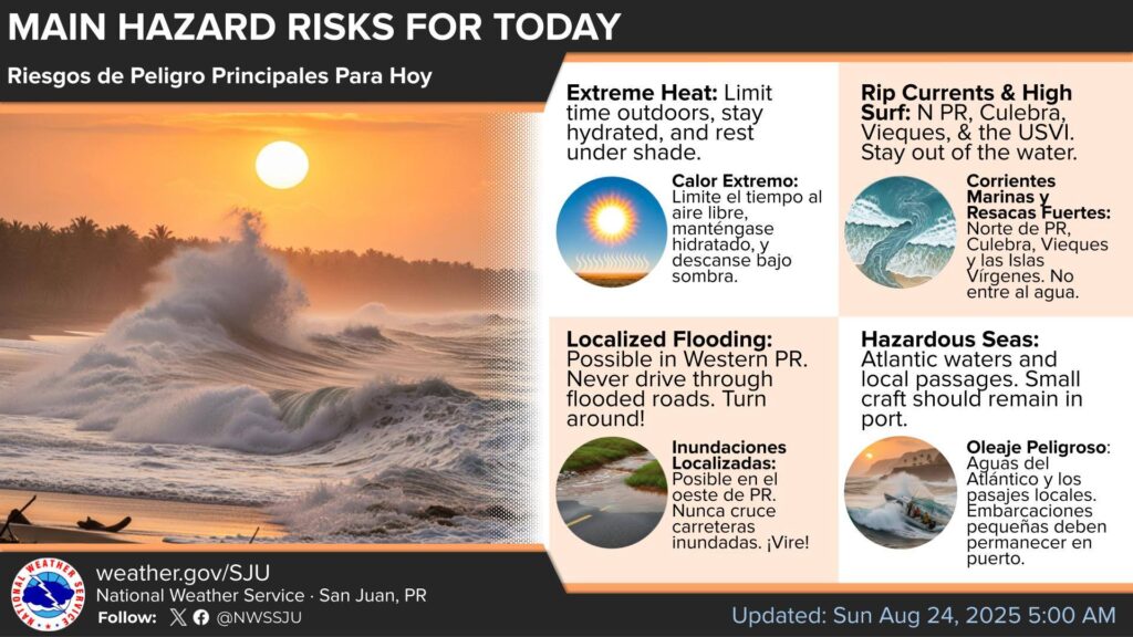
[August 24] Today’s Main Hazard Risks
![]()
![]() Extreme Heat: Extreme Heat Warning and Heat Advisory!
Extreme Heat: Extreme Heat Warning and Heat Advisory! ![]() Stay hydrated and seek shade!
Stay hydrated and seek shade!
![]()
![]() Rip Currents and High Surf for the U.S. Virgin Islands, northern Puerto Rico, Culebra and Vieques / Don’t go in the water!
Rip Currents and High Surf for the U.S. Virgin Islands, northern Puerto Rico, Culebra and Vieques / Don’t go in the water!
![]()
![]() Flooding / Flooding: Don’t drive through flooded roads / Don’t cross flooded roads!
Flooding / Flooding: Don’t drive through flooded roads / Don’t cross flooded roads!
wat️![]() Hazardous Seas / Dangerous Oil: Atlantic waters & local passages. Small craft should remain in port / Atlantic waters and local passages. Small boats need to remain in harbor.
Hazardous Seas / Dangerous Oil: Atlantic waters & local passages. Small craft should remain in port / Atlantic waters and local passages. Small boats need to remain in harbor.
![]()
![]() Other Hazards: Thunderstorms with frequent lightning/ Isolated thunderstorms with frequent lightening; Saharan Dust / Sahara Dust → Hazy skies & poor air quality / Foggy skies & poor air Quality.
Other Hazards: Thunderstorms with frequent lightning/ Isolated thunderstorms with frequent lightening; Saharan Dust / Sahara Dust → Hazy skies & poor air quality / Foggy skies & poor air Quality.
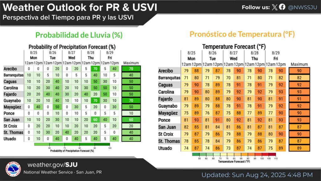
[August 24] Pay attention to the hot temperatures and/or shower activity this week.
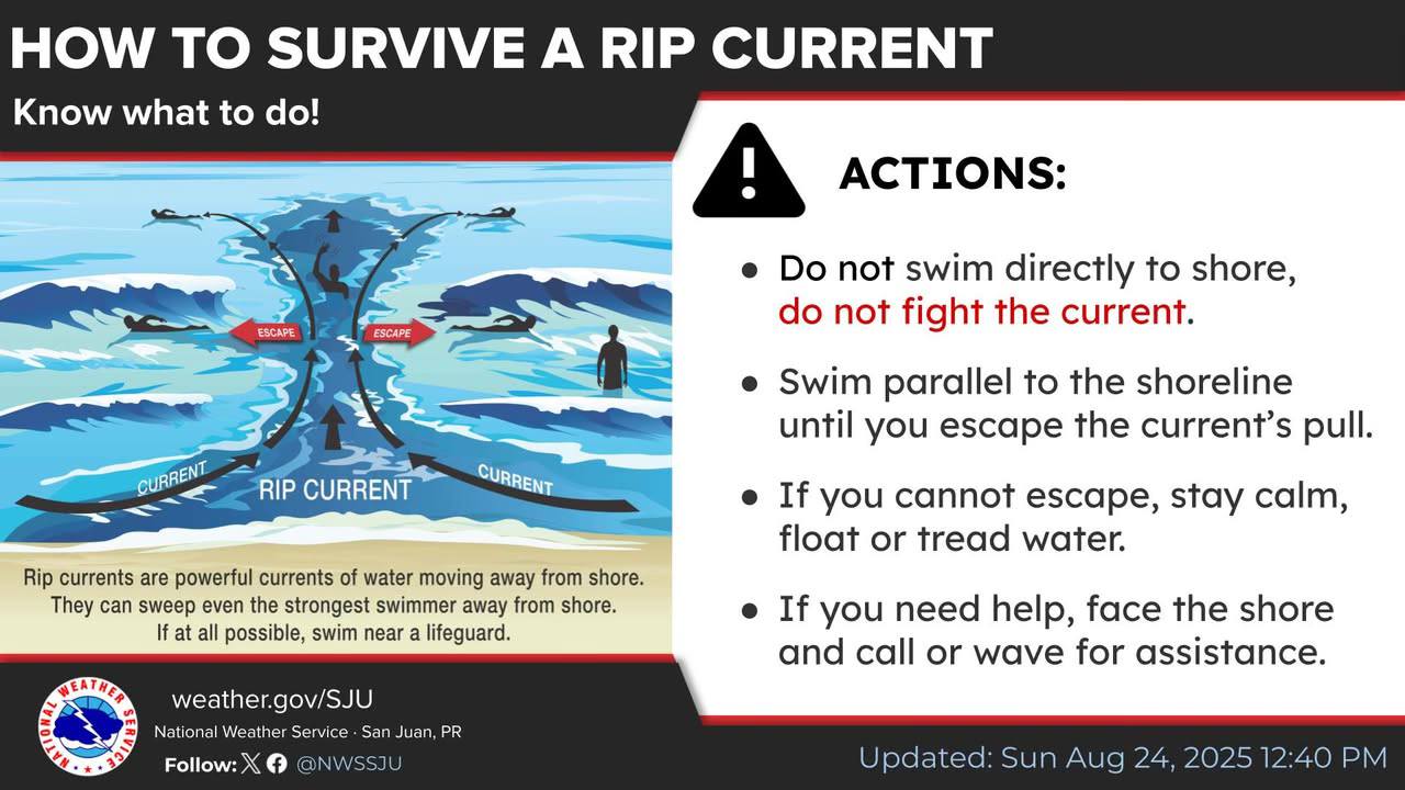
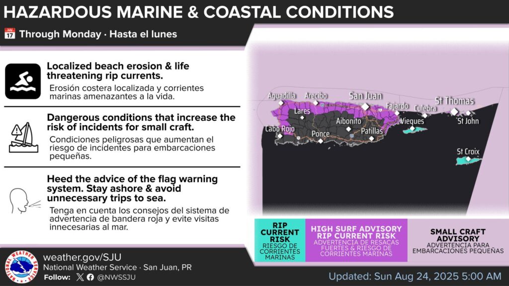
Along the Atlantic coast of Puerto Rico and the U.S. Virgin Islands, we have life-threatening breaking waves and rip currents. Several situations were reported due to these coastal hazards.
The NWS is trying to spread the word to avoid more incidents along the Atlantic Coastline or north-facing beaches.
Hazardous Weather Outlook
From the National Weather Service at 4:51 a.m. AST Sunday August 24, 2025 for St. Thomas, St. John and adjacent Islands such as St. Croix and its nearshore Atlantic and adjacent Caribbean coastal waters.
This Hazardous Weather Outlook is for portions of U.S. Virgin Islands.
DAY ONE (Today and Tonight)
- Excessive Heat…This level of heat affects primarily individuals sensitive to heat, especially those without effective cooling and/or adequate hydration. Those extremely sensitive to heat face the highest risk. Some health systems and heat-sensitive industries could be affected.
- Wind…Breezy conditions (18-22 kts | 21-25 mph). Unsecured items could blow around.
- Marine Conditions…Hazardous conditions for small craft in areas with seas of 7 feet or higher, particularly across the Atlantic waters and local Caribbean Passages. Small craft should exercise caution elsewhere across the local waters.
- Rip Currents…Life-threatening rip currents are likely in the surf zone. Isolated stronger rip currents possible elsewhere, especially near piers, jetties and channels.
DAYS TWO THROUGH SEVEN (Monday through Saturday)
The threat of excessive heat is expected to persist throughout the work week. Northerly swells generated by former Hurricane Erin will continue to produce hazardous marine conditions and maintain a high risk of life-threatening rip currents, a situation further exacerbated by moderate to fresh winds through the middle of the week. Additionally, a plume of the Saharan Air Layer (SAL) will continue moving in through Tuesday, bringing hazy skies, reduced visibility, and deteriorating air quality.

HEAT ADVISORY IN EFFECT FROM 10 AM THIS MORNING TO 5 PM AST THIS AFTERNOON
* WHAT…This level of heat affects primarily individuals sensitive to heat, especially those without effective cooling and/or adequate hydration. Impacts possible in some health system and in heat-sensitive industries.
* WHERE… In the Virgin Islands, St Croix, St. Thomas, St. John and adjacent Islands such as Water Island…In Puerto Rico, Culebra and Vieques also.
* WHEN…From 10 AM this morning to 5 PM AST this afternoon.
* IMPACTS…Hot temperatures and high humidity may cause heat illnesses.
Recommended actions
Drink plenty of fluids, stay in an air-conditioned room, stay out of the sun, and check up on relatives and neighbors.
Take extra precautions when outside. Wear lightweight and loose-fitting clothing. Try to limit strenuous activities to early morning or evening. Take action when you see symptoms of heat exhaustion and
heat stroke.
Coastal Hazard Message
From the National Weather Service in San Juan Puerto Rico at 349 a.m. AST Sunday August 24, 2025 for Vieques Island and St. Croix Island.
…HIGH RIP CURRENT RISK IN EFFECT THROUGH LATE MONDAY NIGHT…
* WHAT…Life-threatening rip currents.
* WHERE…Beaches of northern and northwestern Vieques and St. Croix.
* WHEN…Through late Monday night.
* IMPACTS…Rip currents can sweep even the best swimmers away from shore into deeper water, where it becomes difficult to return to safety.
PRECAUTIONARY/PREPAREDNESS ACTIONS…
There is a high risk of rip currents.

Rip currents are powerful channels of water flowing quickly awayf rom shore, which occur most often at low spots or breaks in the sandbar and in the vicinity of structures such as groins, jetties and piers. Heed the advice of lifeguards, beach patrol flags and signs.

If you become caught in a rip current, yell for help. Remain calm, do not exhaust yourself and stay afloat while waiting for help. If you have to swim out of a rip current, swim parallel to shore and back toward the beach when possible. Do not attempt to swim directly against a rip current as you will tire quickly.