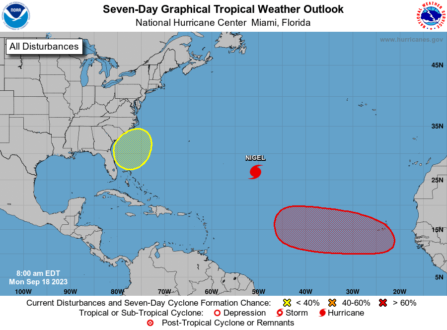
MIAMI — Forecasters say Tropical Storm Nigel now a hurricane; storm poses no threat to land as it swirls through Atlantic.
With the northerly swell still hitting northern Puerto Rico, a High Rip Current Risk statement continues for northern and western Puerto Rico and for Culebra, while the risk is moderate for Vieques and all of the U.S. Virgin Islands.
Surprisingly, we are still feeling the remaining impacts of Post Tropical Cyclones Lee and Margot on our regional waters and coastal areas. Dangerous maritime and coastal conditions will persist until at least Tuesday. Please take care!
Another hot day with afternoon thunderstorms across interior to western Puerto Rico is expected for today.

Eastern Tropical Atlantic
A tropical wave is expected to move off the west coast of Africa by Wednesday.
Environmental conditions are forecast to be conducive for gradual development of the wave
thereafter, and a tropical depression is likely to form late this week or this weekend while the system moves westward across the eastern and central tropical Atlantic.
* Formation chance through 48 hours…low…near 0 percent.
* Formation chance through 7 days…high…70 percent.

Western Atlantic
A non-tropical area of low pressure is forecast to form near the southeastern coast of the United States late this week.
This system could acquire some subtropical characteristics this weekend if it remains offshore while it moves slowly northward or northwestward.
* Formation chance through 48 hours…low…near 0 percent.
* Formation chance through 7 days…low…30 percent.


