
MIAMI — Atlantic hurricane season officially starts June 1, but doesn’t usually ramp up until July or August. But an unusually early tropical storm has a strong chance to develop next week in the “main development region” of the tropical Atlantic. The potential storm is already of interest to the Windward Islands, which mark the divide between the Atlantic and the Caribbean.
The system isn’t a tropical depression yet, but it’s in an environment that favors organization. Weather models are bullish on its prospects of development, and overall steering currents would take it west toward the Caribbean.
It’s not yet known to what extent it will intensify, but it’s worth keeping close tabs on it as it evolves over the coming days. If it organizes and attains sustained winds of at least 39 mph, it will be named Tropical Storm Bonnie.

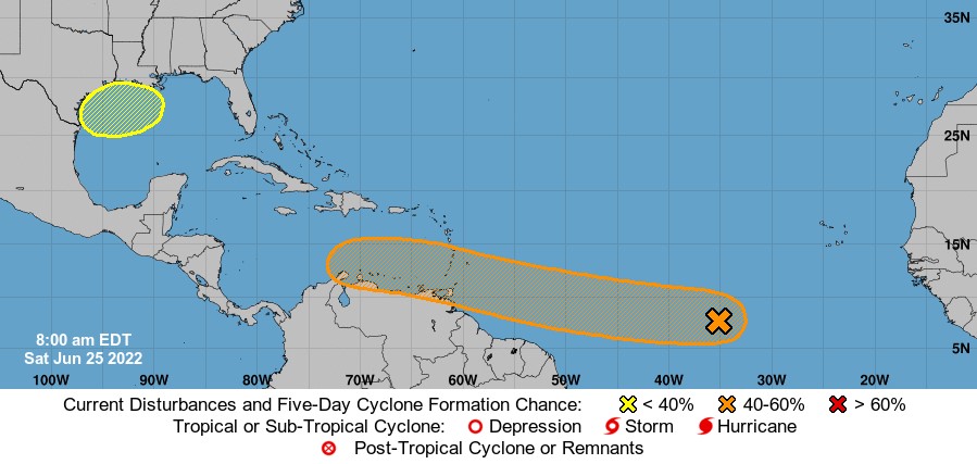
The National Hurricane Center in Miami estimates a 60 percent chance of eventual development, writing: “A tropical depression could form during the early to middle part of next week … and approaches the windward islands.” Thereafter, the system should wind up somewhere in the Caribbean. Eventually, it could affect Central America.
As it stands, experts have unanimously predicted an active or hyperactive hurricane season, the anticipated effects of a lingering La Niña coupling with anomalously warm sea surface temperatures.
The system is currently a mere cluster of showers and thunderstorms about 600 miles south-southwest of the Azores. Downpour activity is more prevalent on the northern half of the system.
That’s also where signs are beginning to manifest of loosely organized outflow, or air exiting the storm at high altitudes. Tropical cyclones are, in essence, heat engines — they ingest warm, humid air in contact with the bath-like sea surface at the low levels, and exhale “spent” air aloft. The more efficiently a system can evacuate already-processed air from above, the easier it is to draw in more moisture-laden air from below and intensify.
In the coming days, the nascent system will meander west through a relative minimum in wind shear, or a change of wind speed and/or direction with height. Wind shear can be pernicious and disruptive to a tropical system, knocking it off-kilter and inhibiting its organization. The lack of wind shear is a window of opportunity. It remains to be seen to what extent the clumping of downpours can take advantage of improving environmental conditions in the days ahead.
From its current perch in the eastern tropical Atlantic, the system should continue almost due west, with little to interrupt its motion. Weather models suggest it will remain a diffuse area of spin before consolidating sometime in the Monday to Wednesday time-frame, potentially on final approach to the Windward Islands.
