
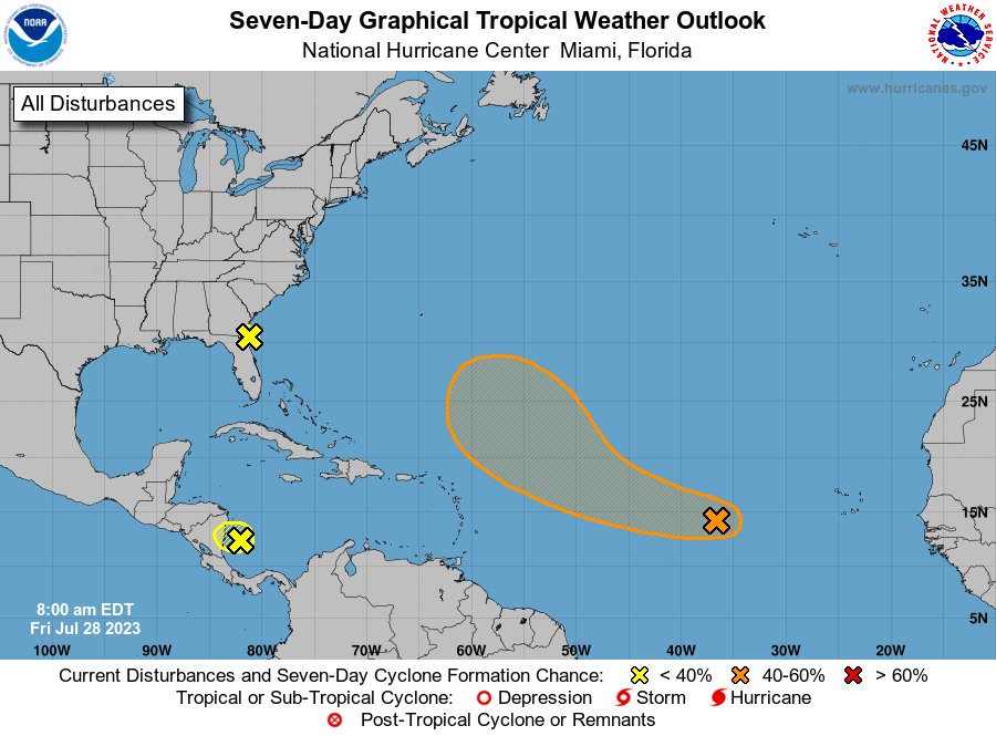
MIAMI —The National Hurricane Center is closely monitoring three disturbances in the tropical Atlantic and the Caribbean Sea today.
First, in the Central Tropical Atlantic, shower and thunderstorm activity associated with a tropical wave located about midway between the Cabo Verde Islands and the Lesser Antilles has increased since yesterday.
Environmental conditions are expected to be favorable for additional gradual development of this system during the next few days, and a tropical depression could form early next week while the system moves generally west-northwestward over the tropical Atlantic. It has a low (20 percent) chance of formation during the next 48 hours and a medium (60 percent) chance in the next seven days.
Second, in the Southwestern Atlantic, disorganized showers and thunderstorms over the far western Atlantic near the coasts of Georgia and northeastern Florida are associated with a weak area of low pressure that has formed just east of Jacksonville. This system is moving north-northwestward and is forecast to move inland over northeastern Florida and eastern Georgia today, and additional development is not expected. Regardless of development, locally heavy rainfall is possible over northeastern Florida, eastern Georgia and portions of eastern South Carolina during the next day or so. It has a near-zero chance of formation during the next 48 hours and seven days.
Third, in the Southwestern Caribbean Sea, we have a large area of disorganized showers and thunderstorms over the southwestern Caribbean Sea is associated with a tropical wave and a broad area of low pressure. This system is forecast to move westward over Central America later today or tonight, and significant development is not anticipated. Regardless of development, locally heavy rainfall is possible over portions of Nicaragua and Honduras during the next day or so. It has a low (10 percent) chance of formation during the next 48 hours and in the next seven days.