
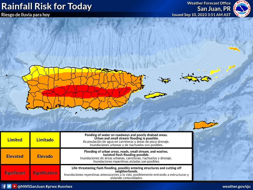
SAN JUAN — Light winds could enhance rain and thunderstorm activity today over Puerto Rico’s Central Range, moving and slowly expanding towards coastal areas. The activity will be mostly seen in the afternoon hours.
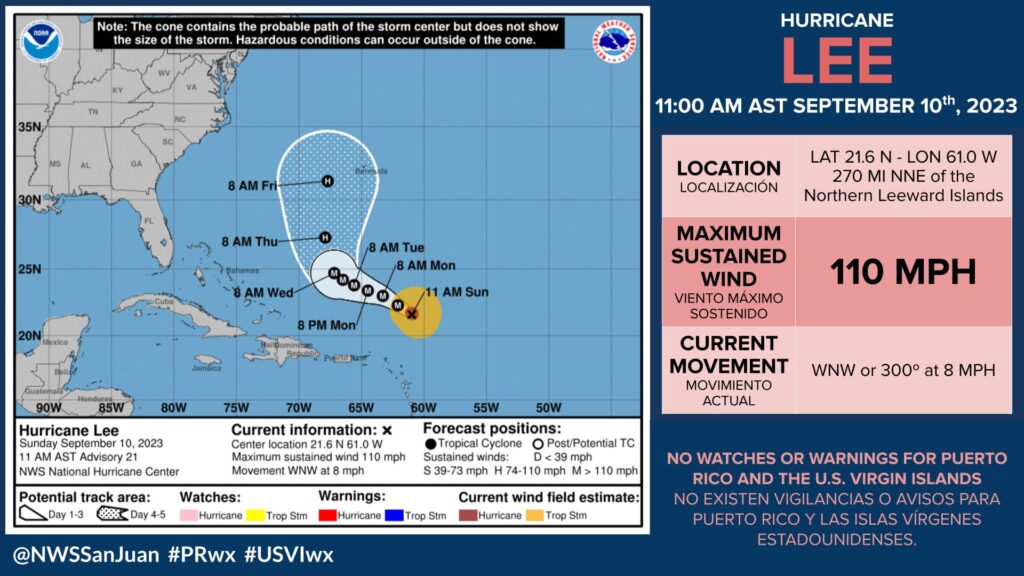
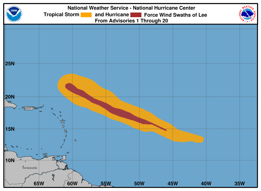
Hurricane Lee is currently located at latitude 21.4 N and longitude 60.5 W. Lee is not anticipated to pose a direct threat to the U.S. Virgin Islands and Puerto Rico. It is projected to move well north of the region today and maintain this course until midweek. As a result, the wind flow will become south to south-westerly during much of the course of next week.
Potential Threats
The swell generated by Lee will reach the islands today, rapidly deteriorating marine and coastal
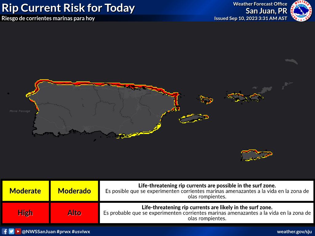
conditions. A high risk of rip current is in effect for northwest to northeast facing beaches of Puerto Rico, Culebra and St. Croix. The breaking waves will increase to 10 feet or more across the north and east-facing beaches in St Croix and also the Atlantic Coastline of Puerto Rico from today onwards.
The swell will peak Monday through Wednesday, when seas between 10 and 15 feet are forecast, especially for the Atlantic and eastern waters. The breaking waves will also peak between 15-20 feet Monday into Wednesday. Coastal flooding may affect the most vulnerable areas along the Atlantic
Coastline of Puerto Rico and the eastern half of St Croix.
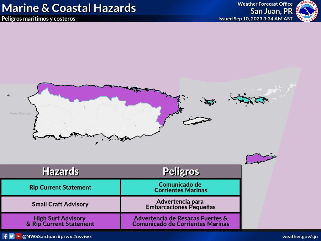
Small Craft Advisories are in effect for the Atlantic Waters, Anegada Passage, and the Local waters of the northern Virgin Islands, including St. Thomas, St. John and Water Island.
There is a High Risk of Rip Currents for the north and east-facing beaches in St Croix, Culebra, St Thomas, and Puerto Rico. High Surf Advisories are also in effect for St. Croix. A High Surf Advisory will be in effect from 6 pm this evening through 6 pm Tuesday for the north facing beaches of Puerto Rico and a coastal flood advisory may also be required later this afternoon.
The winds will become light to gentle due to the effects from the broad cyclonic circulation of Lee. This may enhance the likelihood of experiencing flooding rains during the afternoon. As a result, rainfall amounts may range between 2 and 4 inches, with the possibility of isolated higher amounts, particularly in the Cordillera and eastern Puerto Rico.
After this activity forms, it could spread to the surrounding areas. Please continue to follow the Virgin Islands Free Press online, on Facebook and on X for timely updates.
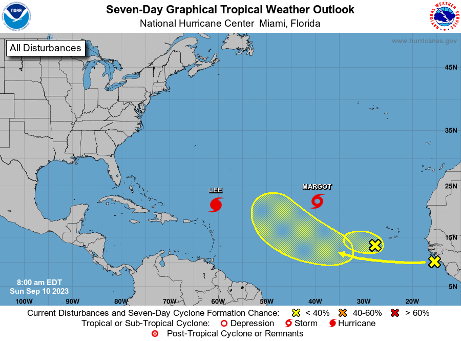
The National Hurricane Center is issuing advisories on Hurricane Lee, located a few hundred miles northeast of the northern Leeward Islands, and on Tropical Storm Margot, located over the central subtropical Atlantic.
Eastern Tropical Atlantic
Shower and thunderstorm activity associated with a small area of low pressure, located a few hundred miles to the southwest of the Cabo Verde Islands remains disorganized.
Environmental conditions appear to be only marginally favorable for development as the disturbance moves slowly westward over the eastern tropical Atlantic.
The system is forecast to merge with a larger tropical wave to its east by midweek and no further development after that time is expected.
* Formation chance through 48 hours…low…30 percent.
* Formation chance through 7 days…low…30 percent.
Eastern and Central Tropical Atlantic
A tropical wave located near the west coast of Africa is producing disorganized showers and thunderstorms.
Environmental conditions appear conducive for some gradual development of this system during the latter part of this week as it moves westward to west- northwestward at 15 to 20 mph over the central tropical Atlantic.
* Formation chance through 48 hours…low…near 0 percent.
* Formation chance through 7 days…low…30 percent.