
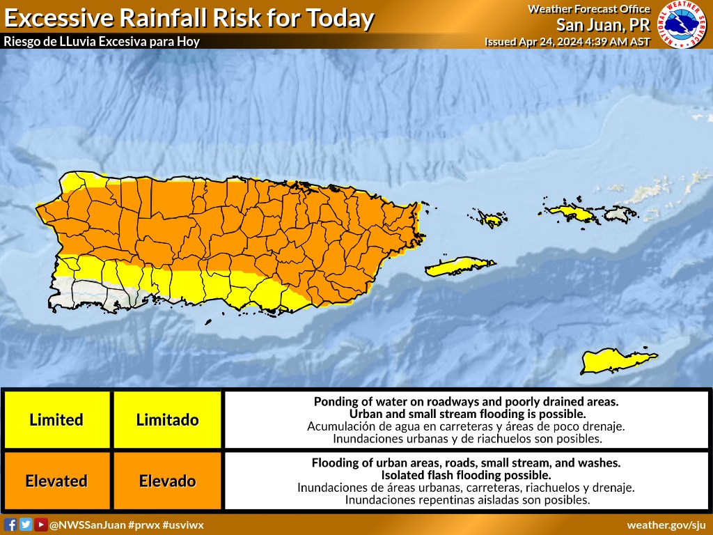
SAN JUAN — Another active afternoon is expected again, mainly for the interior, north and east of Puerto Rico, the National Weather Service said today.
Because of rain and thunderstorms in the forecast, there is an elevated risk of flooding, river overflows and mudslides throughout the day, according to the NWS.
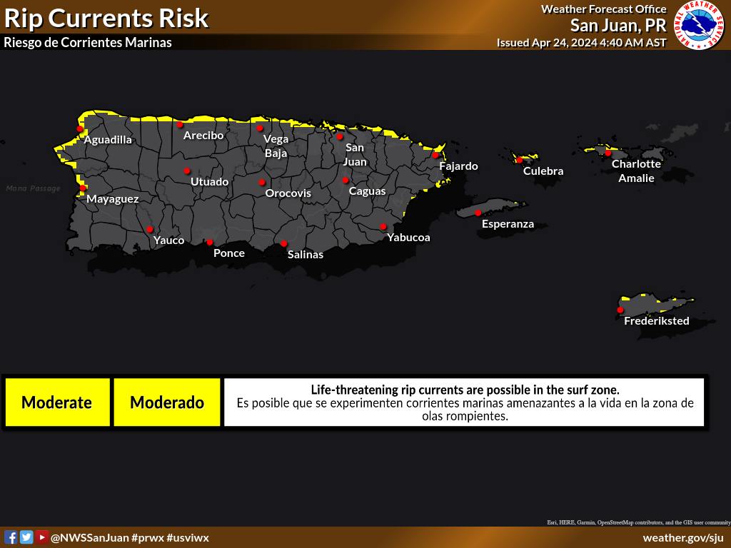
Also, there is a low risk of rip currents today, increasing to moderate tonight across the northern beaches of the islands, the NWS said.
‘Gentle’ Trade Winds in the Caribbean Sea
Gentle to moderate trade winds are north of 15N, except fresh near the Windward Passage and in the Lee of Cuba, with moderate to fresh trade winds south of 15N, locally strong near Colombia.
Seas are 2 to 5 feet across the basin, locally 6 feet in the south-central Caribbean.
For the forecast, high pressure will build north of the area supporting fresh to locally strong winds just north of Colombia, through the Windward Passage, and in the lee of Cuba today through
Thursday.
Looking ahead, further building of the high on starting on Friday will also force fresh to strong trade winds into the Gulf of Honduras and just south of Hispaniola through the weekend.
Today’s St. Thomas-St. John weather forecast above
Strong thunderstorms, heavy rainfall in Hispaniola
A persistent surface trough extending southwestward from 27N61W to western side of Puerto Rico is providing moist southerly flow across Hispaniola.
Together with a pronounced mid to upper-level trough in the vicinity, strong thunderstorms are likely during the afternoon and early evening hours over and near Hispaniola today and Thursday.
These thunderstorms are capable of producing heavy downpours, increasing the chance for flash flooding, especially in hilly terrain and low-lying areas.
Turks and Caicos and Cuba
For the forecast west of 55W, the front will reach from 31N59W to the Turks and Caicos Islands this evening where it will stall and dissipate to a remnant trough.
Associated northerly swell of 8 feet or greater will subside by this evening.
Fairly tranquil conditions are forecast Thursday and Thursday night.
Looking ahead, a new cold front will merge with the trough and progress eastward, reaching 31N57W to eastern Cuba on Saturday morning, and then 25N55W to Hispaniola on Sunday morning.
A swell will push south of 31N with the front, resulting in building seas.
A strengthening Bermuda High should cause widespread fresh to strong north to east winds west of the front beginning Friday evening through Sunday evening.
Monsoon trough in the Inter Tropical Convergence Zone
The monsoon trough enters the Atlantic near 08N13W extending southwestward to 02N16W. The ITCZ continues from 02N16W to 02S21W to 00N36W to just NE of the coast of Brazil near 00N44W.
Scattered moderate isolated strong convection is noted from 02N to 07N between 15W and 23W, and from 00N to 03N between 28W and 41W.
Significant swell in the Central Atlantic
A 1010 mb low pressure near26N35W will slowly drift southwestward through Thursday, opening up to a trough on Friday.
A large area of fresh to near gale-force northeastern winds has generated large seas with heights of 12 to 13 ft N of 25N between 35W and 42W.
Seas of 8 feet or greater cover the waters north of 22N between 30W and 46W.
Scattered showers and thunderstorms are possible within 30 nautical miles of the low center per recent satellite imagery.
Peak seas will subside to less than 12 feet through this evening as the low weakens and gradually opens up to a trough.
Meanwhile, winds will diminish to 20 knots or less by Thursday evening.
Please read the latest High Seas Forecast issued by the National Hurricane Center at https://www.nhc.noaa.gov/text/MIAHSFAT2.shtml for more details.