MIAMI — Tropical Storm Helene formed this morning in the northwestern Caribbean Sea and is getting better organized, according to the latest advisory from the National Hurricane Center.
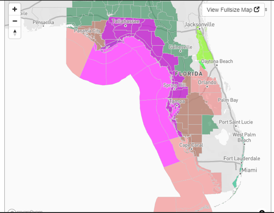
Watches and warnings ahead of the storm were expanded for Florida at the 11 a.m. advisory. Several portions of Florida are under a hurricane watch, tropical storm watch or warning, and storm surge watch.
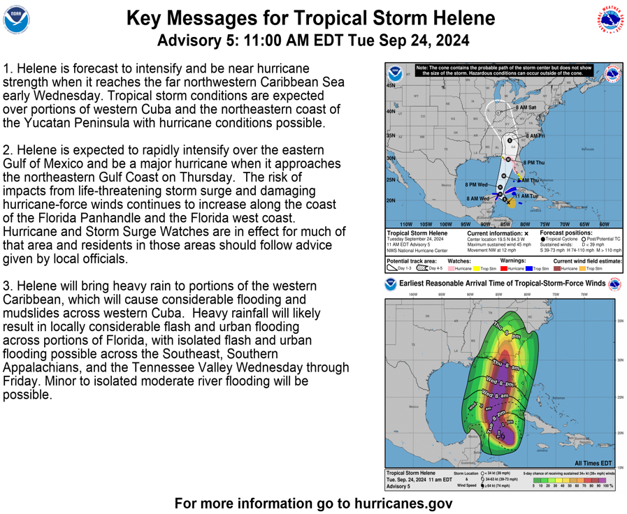
The storm that is expected to become a hurricane tomorrow could become a Category 3 hurricane with 115-mph winds by the time it makes landfall Thursday.
“The potential for life-threatening storm surge and damaging hurricane-force winds along the coast of the Florida Panhandle and the Florida west gulf coast is increasing,” the Hurricane Center said.
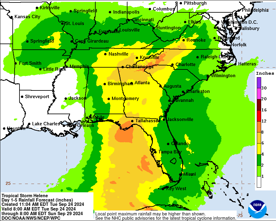
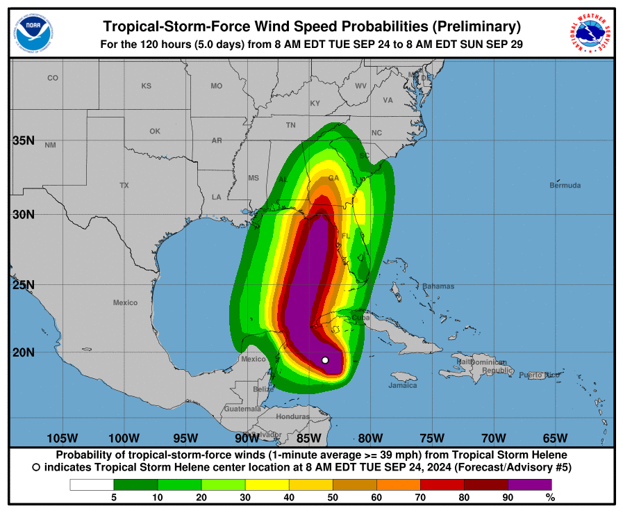
“Due to the forecast large size of this system, storm surge, wind, and rainfall impacts will extend well away from the center, particularly on the east side. In addition, the fast forward speed while it crosses the coast will likely result in farther inland penetration of strong winds over parts of the southeastern United States after landfall,” the Hurricane Center advisory warned.
“Everyone along the Florida Panhandle and Big Bend region needs to be prepared for hurricane impacts,” said AccuWeather Lead Hurricane Expert Alex DaSilva, adding the system has the potential to become the strongest hurricane landfall in the U.S. so far this season.
“AccuWeather expert meteorologists expect this to be a highly impactful storm,” AccuWeather Chief Meteorologist Jon Porter said. “This could be the storm that the 2024 hurricane season is remembered for.”
Florida Governor Ron DeSantis issued a state of emergency Monday afternoon for 41 of Florida’s 67 counties, including all of the Florida Panhandle.
Potential Tropical Cyclone Nine: What you need to know
- Location: 240 miles south-southeast of the western tip of Cuba
- Maximum sustained winds: 35 mph
- Movement: northwest at 8 mph
- Pressure: 1,001 mb
- Next advisory: 8 a.m.
Watches, warnings issued across Florida as Potential Tropical Cyclone 9 approaches
“Due to the forecast large size of this system, storm surge, wind, and rainfall impacts will extend well away from the center, particularly on the east side. In addition, the fast forward speed while it crosses the coast will likely result in farther inland penetration of strong winds over parts of the southeastern United States after landfall,” the Hurricane Center advisory warned.
“Everyone along the Florida Panhandle and Big Bend region needs to be prepared for hurricane impacts,” said AccuWeather Lead Hurricane Expert Alex DaSilva, adding the system has the potential to become the strongest hurricane landfall in the U.S. so far this season.
Hurricane watch: A hurricane watch means that hurricane conditions are possible within the watch area. A watch is typically issued 48 hours before the anticipated first occurrence of tropical-storm-force winds.
The Weather Channel announced its team coverage plan on X, formerly known as Twitter. Meteorologist Jim Cantore, well known for his reporting in the middle of a hurricane, is in Port Richey today, September 24.
More Weather Channel coverage is based along the Gulf Coast, from Panama City Beach to Tampa.