
SAN JUAN — Long-periods of northerly swells will produce hazardous marine and coastal conditions throughout the weekend due to dangerous breaking waves across the north, east, and west-facing beaches, the National Weather Service said this morning.
A COASTAL FLOOD ADVISORY HAS BEEN ISSUED FOR THE NORTHERN BEACHES OF PUERTO RICO UNTIL AT LEAST 8:00 PM AST THIS EVENING, according to the NWS.
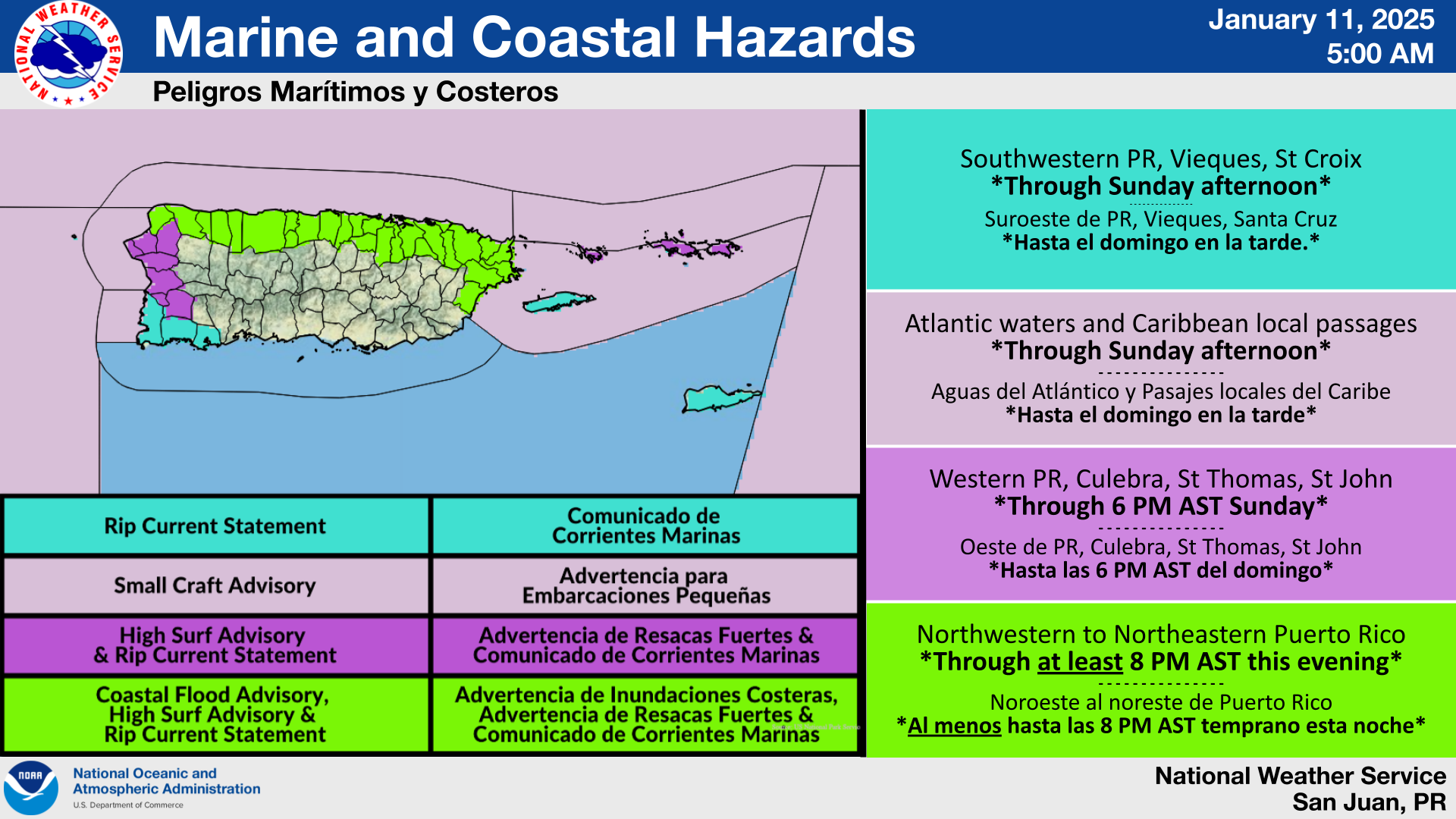
Areas at Risk and Timing
- For marine hazards: Small Craft Advisories are in effect across the Atlantic waters and local Caribbean passages until Sunday afternoon.
- For coastal hazards:
* There is a high risk of rip currents along the northwestern to northeastern coast of Puerto Rico, Culebra, St. Thomas, and St.John until Sunday afternoon due to breaking waves around 10 to 12 feet and occasionally higher. In the southwest coast, Vieques and St. Croix due to breaking waves around 6 feet.
* A high surf advisory is in effect from the northwest coast, all of the north, and the east coast of Puerto Rico, Culebra, St. Thomas, and St. John until Sunday afternoon due to breaking waves up to 10 to 13 feet.
* A coastal flood advisory is in effect for the beaches exposed to the north of Puerto Rico, from Aguadilla to Fajardo, at least until 8 PM AST this evening due to breaking waves up to 14 to 15 feet.
Hazards & Potential Impacts
- Small Craft Advisory: Hazardous seas impacting small crafts.
- High Rip Current Risk: Rip currents with the potential to pull even experienced swimmers away from shore.
- High Surf Advisory: Large breaking waves can wash over jetties, sweeping people and pets onto rocks, and rough surf may knock individuals down. Localized beach and dune erosion, along with dangerous swimming conditions are likely. Localized minor flooding and damage to beachfront structures is possible.
- Coastal Flood Advisory: Large breaking waves may cause moderate to significant beach erosion and considerable dune damage. Shallow flooding in vulnerable areas could lead to property and structural damage, especially near high tide, with a higher risk of flooding and vehicle damage. Isolated or widespread road closures are possible. The threat to life increases for those who enter hazardous areas.
For updates on marine conditions, rip currents, and other hazard risks, along with a detailed map of the areas at risk, refer to the Experimental Graphical Hazard Weather Outlook: https://www.weather.gov/erh/ghwo?wfo=sju.