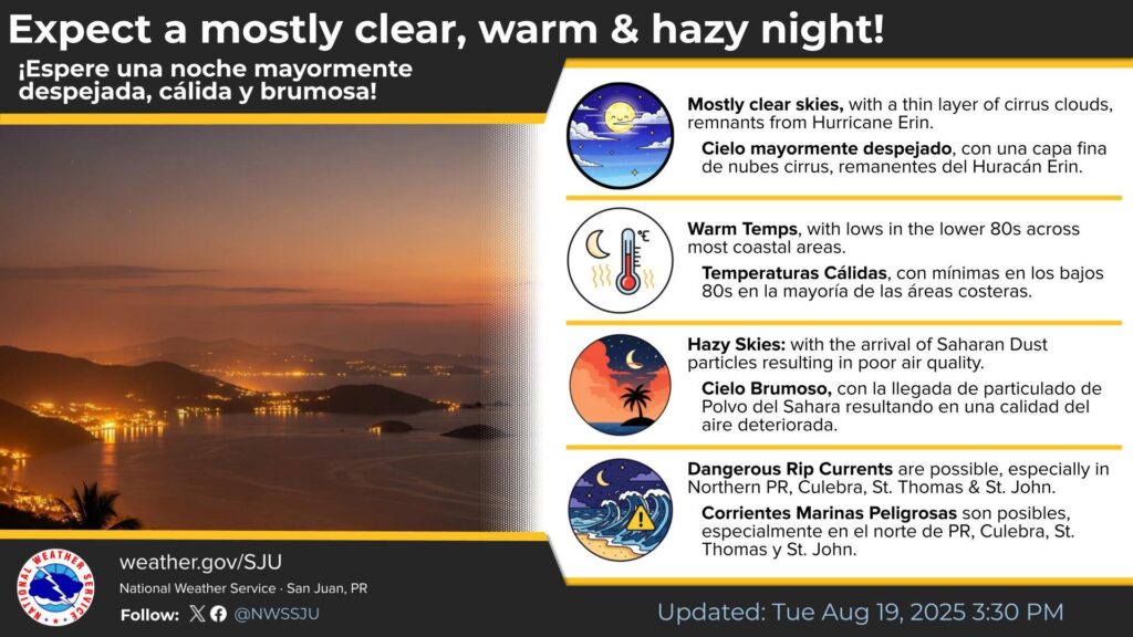
CHRISTIANSTED — Today and tonight: Excessive Heat…This level of heat affects individuals most sensitive to heat, especially those without effective cooling and/or adequate hydration. Those extremely sensitive to heat face the highest risk. Some health systems and heat-sensitive industries could be affected. These conditions will affect mostly all the U.S. Virgin Islands, Culebra and Vieques.
Rip Currents...Life-threatening rip currents are possible in the surf zone, particularly across the northern U.S. Virgin Islands Isolated stronger rip currents may occur elsewhere, especially near piers, jetties, and channels.
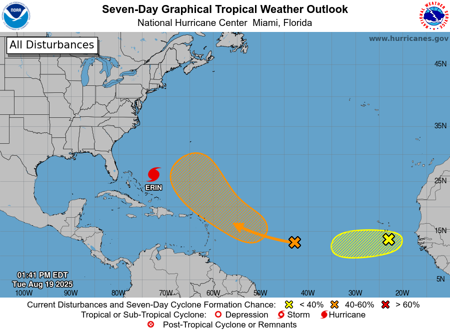
Days two through seven: (Wednesday through Monday)
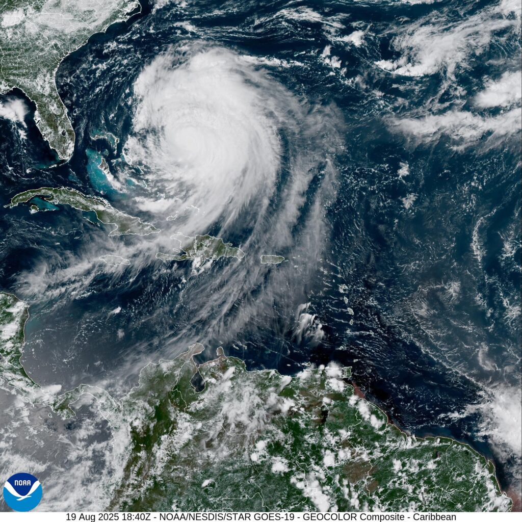
Hot conditions will return to the islands as cloudiness from Erin`s circulation departs. A tropical wave is being monitored by the National Hurricane Center.
This wave could approach the islands by the weekend, increasing the potential for showers and thunderstorms, as well as gusty winds and hazardous marine and coastal conditions.
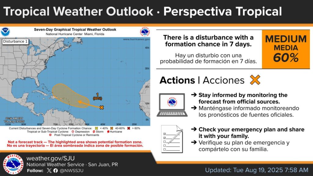
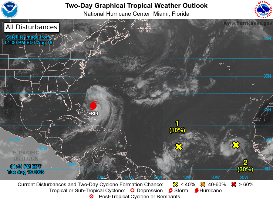
Tropical Weather Outlook
The NHC is monitoring two tropical waves, one of them is located over the central tropical Atlantic.
This tropical wave continues to produce a broad area of disorganized showers and thunderstorms.
Environmental conditions appear conducive for gradual development of this system, and a tropical depression could form toward the end of the week or this weekend.
This system should move westward to west-northwestward at about 20 mph and approach the vicinity of the Leeward Islands on Friday.
Stay informed by monitoring the forecast from official sources.
Check your emergency plan and share it with your family.
Formation chance through 48 hours…low…10 percent.
Formation chance through 7 days…medium…60 percent.
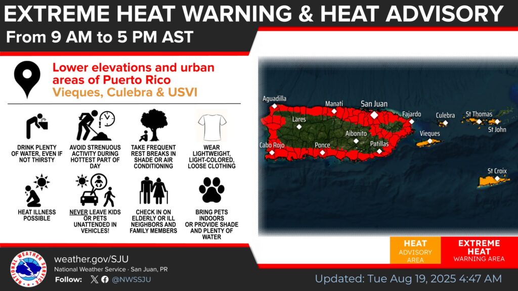
A Heat Advisory is in effect for Culebra, Vieques, St. Thomas, .St. John and adjacent Islands such as St. Croix from 9:00 a.m. to 5:00 p.m. today including: Grove Place, Frederiksted southeast, Charlotte Amalie West, Christiansted, Anna`s Retreat, Frederiksted town, Culebra, Charlotte Amalie, Vieques, Cruz Bay, and Charlotte Amalie East, the National Weather Service said.
* WHAT…This level of heat affect most individuals sensitive to heat, especially those without effective cooling and/or adequate hydration. Impacts possible in some health system and in heat-sensitive industries.
* WHERE…In Puerto Rico, Culebra and Vieques. In Virgin Islands, St. Croix and St. Thomas, St. John, and Adjacent Islands.
* WHEN…From 9 AM this morning to 5 PM AST this afternoon.
* IMPACTS...Hot temperatures and high humidity may cause heat illnesses.
Precautionary preparedness and actions
Take extra precautions when outside. Wear lightweight and loose fitting clothing. Try to limit strenuous activities to early morning or evening. Take action when you see symptoms of heat exhaustion and heat stroke.
To reduce risk during outdoor work, the Occupational Safety and Health Administration recommends scheduling frequent rest breaks in shaded or air conditioned environments. Anyone overcome by heat
should be moved to a cool and shaded location. Heat stroke is an emergency! Call 9 1 1.
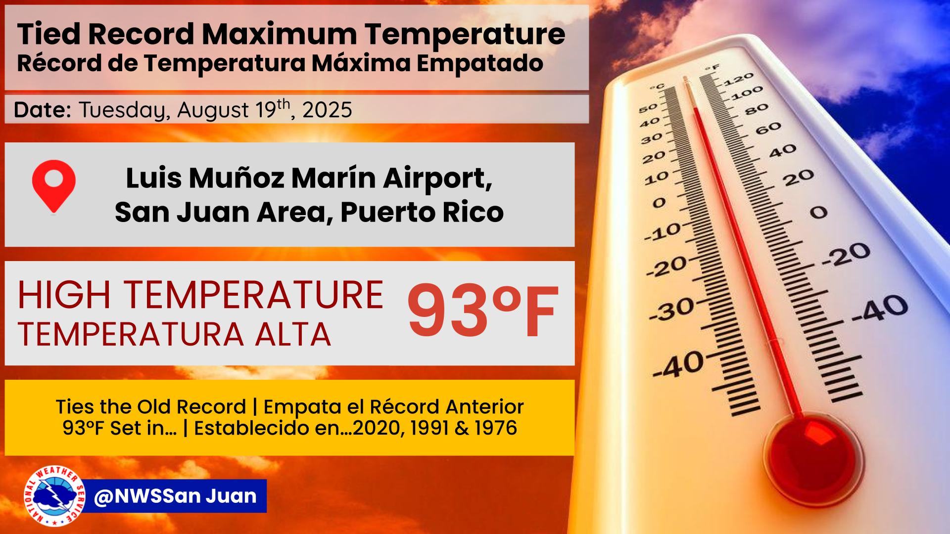
Today: Partly cloudy this morning, then becoming sunny. Isolated showers. Hazy. Highs around 92. Southeast winds 10 to 15 mph. Chance of rain 20 percent.
Tonight: Partly cloudy in the evening, then becoming variably cloudy. Scattered showers. Hazy. Lows around 82. East winds 15 to 20 mph. Chance of rain 30 percent.
Tomorrow: Breezy. Variably cloudy with scattered showers in the morning, then sunny in the afternoon. Hazy in the afternoon. Highs around 92. East winds 15 to 20 mph. Chance of rain 30 percent.