By JOHN McCARTHY / V.I. Free Press News Reporter
ST. CROIX — If your eyes are burning and your nose is running this morning, you are definitely “feeling it.”
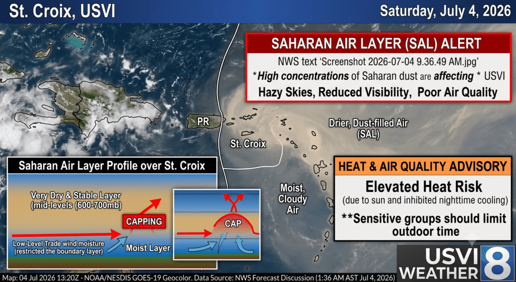
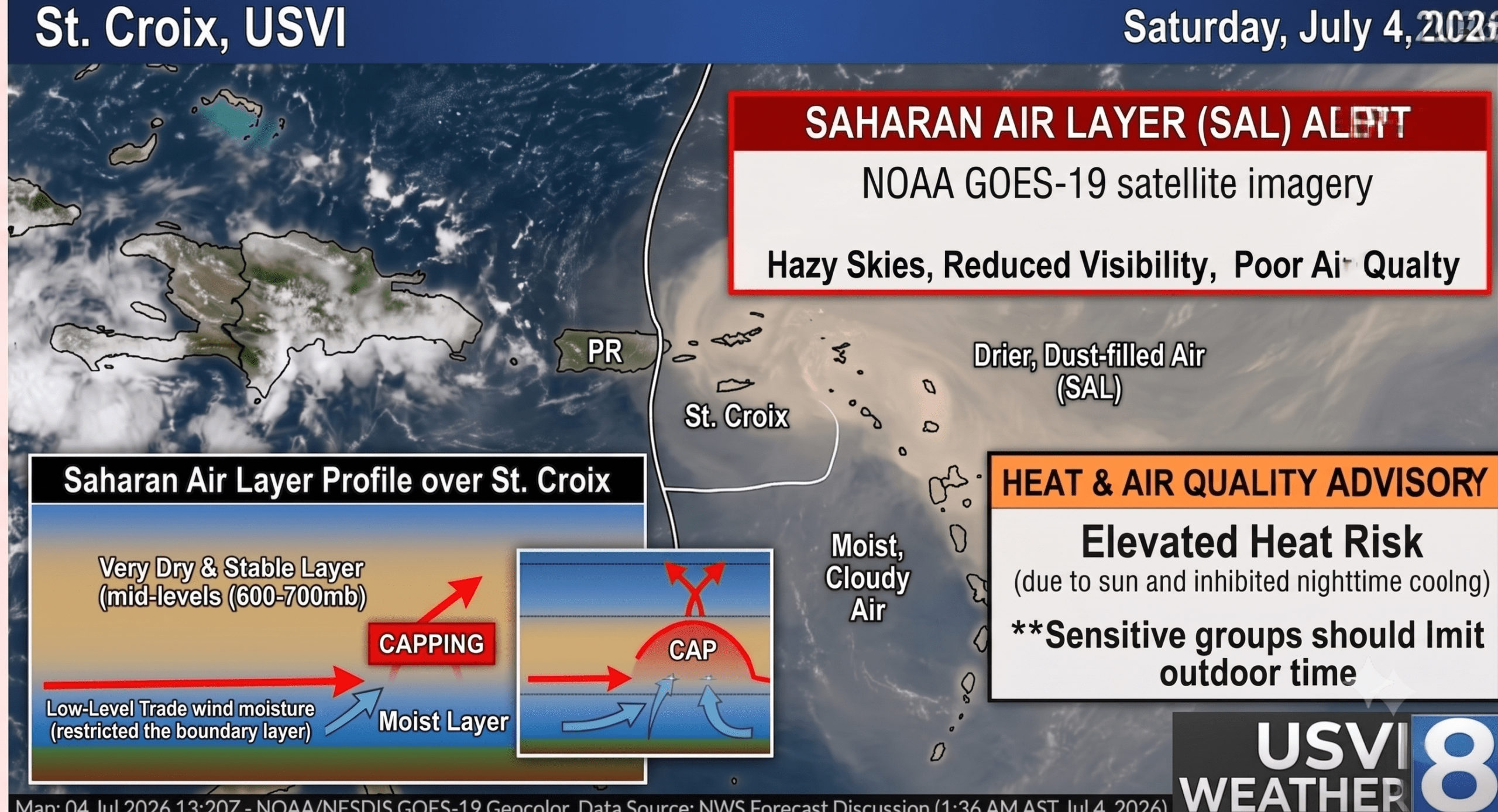
A dense, sweeping plume of the Saharan Air Layer (SAL) has officially blanketed the U.S. Virgin Islands, turning holiday weekend skies a thick, hazy gray, dropping visibility, and plunging regional air quality to poor levels.
For residents trying to enjoy the Independence Day holiday, the combination of intense African dust, stifling humidity, and elevated fire risks means the safest place to celebrate today might just be directly in front of an air conditioner.
Here is what you need to know to navigate the local environment through the holiday weekend.
The Big Picture: Saharan Air Layer (SAL)
The National Weather Service in San Juan confirms that moderate to locally high concentrations of Saharan dust are filtering directly across the northern Caribbean. As captured in the regional satellite imagery from NOAA GOES-19, a massive, visible blanket of dry, dusty air is riding the trade winds, stretching all the way across the Atlantic chain.
- The Impact: Expect heavily obscured, milky skies and a sharp drop in regional visibility today.
- Air Quality Warning: Air quality is poor, particularly for sensitive groups, children, the elderly, and anyone with respiratory conditions or allergies. Even staying indoors might not offer total relief as the fine particulate matter tracks through home ventilation systems.
- Duration: This peak concentration will blanket the territory through Sunday before starting to gradually thin out by Monday.
Stifling Holiday Heat
The presence of the Saharan Air Layer does more than just irritate your respiratory system—it acts like an atmospheric blanket. The dust suppresses standard nighttime cooling, keeping overnight temperatures locked in the low 80s.
Combined with the intense July sun, daytime heat indices are expected to approach Heat Advisory criteria (flirting with 100°F) across coastal and urban areas of the USVI. While widespread morning cloud cover may slightly delay the peak of the afternoon heat, conditions will remain remarkably warm, muggy, and uncomfortable.
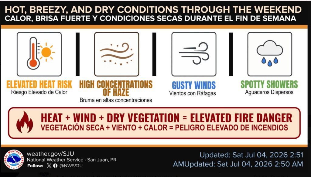
Elevated Fire Risks
While the main hurricane tracking charts from the National Hurricane Center show a peaceful “No Disturbances” outlook across the Atlantic basin, local hazards are strictly focused on the ground.
Because the dry air mass limits vertical cloud growth, rainfall will remain minimal over the weekend, restricted only to brief, fast-moving morning trade showers. Coupled with strong east-southeast winds gusting up to 24 to 28 knots, any fire that sparks this weekend has the potential to spread rapidly.
Given the heightened use of holiday fireworks and outdoor cooking, emergency officials are urging extreme caution around dry brush and grass. A single rogue spark could easily ignite a fast-moving brush fire.
Marine and Beach Conditions
If you are planning to hit the water, be aware that easterly winds will keep the local offshore waters choppy, with seas averaging 3 to 5 feet, and occasionally reaching 6 feet.
A moderate risk of life-threatening rip currents remains in effect for east, north, and south-facing beaches across the territory. If you are swimming, stay near lifeguards, and if you hear thunder from any isolated afternoon cells, seek shelter immediately.
Weather Guidance: How to Handle the Holiday
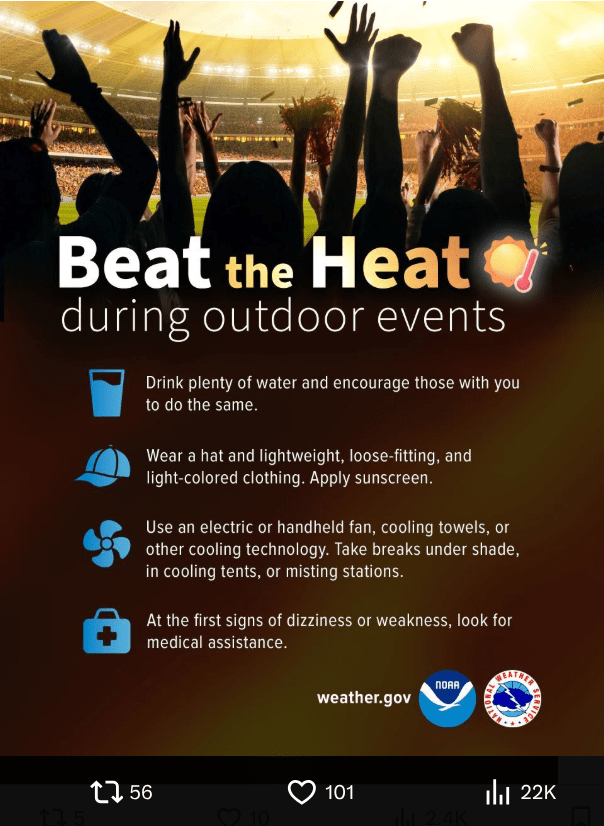
On X, the NWS recommended several baseline precautions for navigating this dual threat of dust and heat:
- Hydrate Constantly: Drink plenty of water throughout the day, even if you don’t feel actively thirsty.
- Protect Yourself: If you must venture into the sun, wear a hat, loose-fitting, light-colored clothing, and apply sunscreen.
- Limit Exposure: Take frequent, prolonged breaks in the shade or in air-conditioned spaces.
- Watch for Symptoms: At the first signs of heat exhaustion—such as dizziness, headaches, or sudden weakness—immediately seek cooler air and medical assistance.