
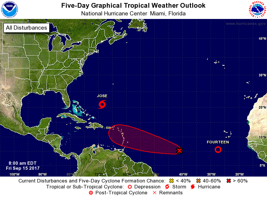
SAN JUAN — As Tropical Storm Jose continues to circle in the Atlantic, posing minimal threat to land, a pair of rough-weather patches off the African coast, one now a tropical depression, are just two more indications that while Irma might be past us, the hurricane season is not.
“The peak of the hurricane season is mid-August through late October, and conditions remain favorable across the Atlantic basin for systems to form and strengthen,” said National Hurricane Center spokesman Dennis Feltgen.
Each system is still far out in the eastern Atlantic, thousands of miles from the territory. One of them became Tropical Depression 14 late Thursday.
The next named tropical system would be called Lee.
The other system is being given a 40 percent chance of developing during the next two days and an 80 percent chance of developing during the next five days.
It’s too early to determine what impact, if any, either would have on the Virgin Islands and Puerto Rico.
The National Hurricane Center’s latest tropical weather maps show each system heading generally toward the Caribbean.
It’s not possible to forecast with any certainty where they would head beyond that. Each are still over 2,000 miles from the Virgin Islands and Puerto Rico.
After forming in the far Atlantic they march westward toward the Caribbean, gathering strength as they make the dayslong journey. They tend to travel north, sometimes toward the United States. Sometimes it’s a hard right turn, other times it’s a gradual drift.
“A common track runs from the far eastern Atlantic toward and onto the U.S.,” Feltgen said, referring to the cyclones that tend to form around this time.
Meanwhile, the National Oceanic and Atmospheric Administration (NOAA) projected today that a “tropical disturbance is forecast to enter and move across the eastern Caribbean” on Wednesday.
“This is still some ways out but will continue to monitor and see how this feature unfolds, NOAA said.
Last night and today the Virgin Islands faces “heavy rainfall” and “thunderstorms,” the federal administration said.
“There is a chance of thunderstorms with heavy rainfall and brief gusty winds this morning and afternoon across the
USVI and the Caribbean coastal waters of the islands,” according to NOAA.
NOAA also issued a flood advisory for St. Croix effective from 6 a.m. to 9 a.m. today and said that “heavy rains could lead to ponding of water on roadways and/or flooding of urban areas and small guts.”
“At 601 AM AST, Doppler radar indicated heavy rain due to thunderstorms moving across the advisory area,” NOAA said. “This will cause urban and small stream flooding. Overflowing poor drainage areas will result in minor flooding in the advisory area. Some locations that will experience flooding include…Grove Place, Frederiksted South, Christiansted and Frederiksted.”
The federal agency also warned about rip currents on north-facing beaches in the islands.
“Hazardous marine conditions with dangerous rip currents are expected to prevail across most of local waters and shorelines until early next week,” NOAA said.